Clean easing surf ahead of large stormy swells

Western Australia Surf Forecast by Craig Brokensha (issued Monday 5th September)
Best Days: Both coasts tomorrow morning, Perth Friday morning, both coasts Saturday and Sunday
Recap
Large clean surf around 6-8ft in the South West Saturday morning, and 1-2ft in Perth, building through the afternoon and peaking Sunday morning to 8-10ft and 2ft+ respectively under offshore winds.
The swell steadied for most of the day with a new reinforcing SW groundswell, ahead of a drop in size back from 8ft early this morning across the South West and 2-3ft to the north but with less than ideal S/SE winds. Protected spots are the pick.
This week (Sep 6 - 9)
Yesterday afternoon's reinforcing SW groundswell will continue to ease into tomorrow, backing off from the 6ft range across swell magnets in the South West tomorrow and 1-2ft in Perth.
Conditions should be clean with a light variable tending offshore wind across most locations ahead of a strengthening N/NW'ly into the afternoon.
This will be linked to a vigorous frontal progression firing up in the Heard Island region last night, projecting a broad fetch of W/SW gales right up and into us today and tomorrow.
The front will move through Wednesday with a large W/SW swell filling in not far behind. Another strong front will race in on top of the active sea state generated by the first system, pushing through Thursday. This will create an even larger W/SW groundswell for Thursday.
Size wise we should see the South West kick to 8-10ft through the day, larger on dark with the stronger front, with 3ft sets in Perth, larger late.
A peak is due Thursday with stormy 12-15ft surf across the South West and 3-4ft sets in Perth, easing back later in the day and further from 8-10ft and 2ft+ respectively Friday.
 Conditions will be poor though with fresh to strong W/NW winds Wednesday, weakening SW tending W'ly winds. Friday doesn't look any better in the South West with a fresh W/NW'ly, but Perth should see a light offshore through the morning.
This weekend onwards (Sep 10 onwards)
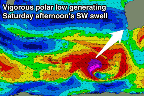
During Saturday a strong new long-period SW groundswell is due across the state, generated by a vigorous polar low firing up to our south-west later this week. A fetch of severe-gale to storm-force W/SW winds will be generated, with the swell due to fill in Saturday, peaking into the afternoon.
Margs should see large 8-10ft sets with 2ft+ waves in Perth and S/SE winds will favour protected spots. Sunday looks the pick with better SE-E/SE winds as the swell eases. More on this Wednesday.