Plenty of swell but no let up in the wind

Western Australia Surf Forecast by Craig Brokensha (issued Wednesday 10th August)
Best Days: Perth every morning over the coming period besides Thursday when the swell's small, Margs Saturday and Sunday mornings for keen surfers
Recap
Large onshore messy waves easing across the state, becoming cleaner into this morning around Perth and Mandurah as the swell dropped back to 2ft on the sets. Moderate onshore winds persisted down South though with 6ft sets.
This week and weekend (Aug 11 - 14)
Through tomorrow we'll see strengthening pre-frontal NW winds ahead of a mid-late afternoon SW change and building short-range W'ly swell. Perth may see N/NE winds early but the swell is likely to be tiny and only around 1-1.5ft.
A better increase in SW groundswell is due Friday afternoon though, generated by a small intense mid-latitude forming south-west of us today. The strength and logevity of this low has been downgraded a touch.
We're due to see Margs building to 6-8ft through the afternoon, with 2ft sets around Perth.
While this groundswell has been downgraded a touch, reinforcing levels of SW energy for the weekend have been upgraded a little.
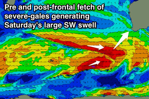 These will be generated by a strong mid-latitude front firing up on the back of the low, aiming a fetch of severe-gale pre-frontal W/NW and then post-frontal W/SW fetch through our south-western swell window.
While not ideally aligned, we'll see good energy spreading radially up towards us, with two pulses Saturday coming in around the 8ft range in the South West and 2ft+ in Perth.
A slow easing trend is then due Sunday, ahead of another smaller reinforcing W/SW pulse Monday to 6ft or so in the South West and 2ft max in Perth.
Now, conditions are looking a bit better than they were on Monday but still not ideal.
Friday will see moderate to fresh W/SW winds across the South West, more variable to the north, and then Saturday lighter W'ly breezes (increasing through the day), variable again to the north. There's a chance for an early N/NE wind Sunday (E/NE to the north), while Monday will see a return to fresh onshore NW winds ahead of a SW change.
Into early next week large levels of mid-period W/SW swell are due from another flurry of mid-latitude frontal activity and onshore winds continue to persist in the South West.
As touched on this pattern isn't due to change until hopefully next weekend, but lets check this again Friday.