Great Tuesday ahead of a large onshore period

Western Australia Surf Forecast by Craig Brokensha (issued Monday 11th July)
Best Days: Tuesday, early Wednesday protected spots in the South West
Recap
Large onshore waves Saturday with a mix of swells, building from the S/SW into the afternoon before easing Sunday.
The S/SW swell eased rapidly as expected with nothing of significance really left over today and along with a persistent onshore SW wind in the South West as the mid-latitude low over the Bight stalled a little longer than expected on Friday. Perth and Mandurah were cleaner with leftover 2ft sets.
This week (Jul 12 - 15)
There's been no real change to the inconsistent S/SW groundswell due across the coast tomorrow morning with Margaret River performing the best size wise. Inconsistent 5-6ft+ sets are due through the morning, easing off through the afternoon and further Wednesday. Perth probably won't get above 1-1.5ft, with 1-2ft sets in Mandurah.
Conditions are looking great with an offshore E/NE tending variable breeze and then less favourable NE tending fresh to strong N/NE winds Wednesday.
A low point in swell activity is due Thursday morning and strengthening N/NW winds will kick up a stormy NW windswell.
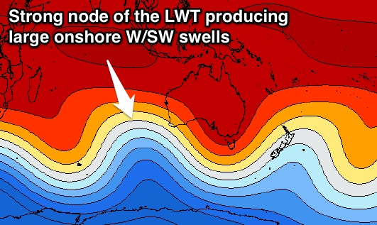 This NW windswell will be linked to a fetch of gale to severe-gale NW winds from a strong front approaching from the west. This front, the first in a series firing up under a strong protruding node of the Long Wave Trough to our west.
This front is forecast to project a fetch of W/SW gales towards us, generating a large W/SW groundswell that's due to arrive later in the day Friday.
A mix of easing NW windswell and weak short-range W'ly swell will arrive before the groundswell coming in at a messy 6-8ft in the South West and 2ft in Perth. The groundswell should kick late to an easy 10ft+ across the South West and 3ft+ in Perth, easing from a similar size Saturday morning.
There may be a brief reprieve in winds early Friday but most likely only light from the NW, freshening again through the day.
Saturday will then see strong W/NW winds as another cold front pushes into the state.
Another large pulse of W/SW groundswell will be linked to this front, generated on the backside of the initial frontal progression. A fetch of gale to severe-gale W/SW winds acting on an already active sea state should produce large another 10-12ft of W/SW groundswell for the South West later in the day but more so Sunday with 3-4ft sets in Perth with strengthening NW winds.
Longer term yet another large W/SW groundswell is on the cards for Monday but the onshore winds will continue as a result of the position of the Long Wave Trough across us. More on this Wednesday.
Comments
Craig, are you guys confident about this swell for tomorrow (12/7)? No one is showing that, just a slow decline from today.
deciding whether to commit to a boat ride
Yep, pretty confident.
thanks you're a legend! i can already see the rottnest bouy increasing in period and height
Geeez the storm track is going northward , get ready for an onslaught on the westside
And what a Tuesday it was..