Large surf to continue, limited windows of clean conditions

Western Australia Surf Forecast by Craig Brokensha (issued Wednesday 27th April)
Best Days: Perth Saturday and Sunday morning, protected breaks in the South West Saturday and then most spots Sunday morning
Recap
Large stormy waves in the 8ft+ range continued across the South West yesterday with no options for a decent surf until the afternoon in protected spots, with 3ft chops further north.
Today the swell has eased back to the 6ft+ range across the South West as onshore SW winds continued, while further north light offshores created much cleaner conditions with the surf back to 2-3ft.
This week and weekend (Apr 28 – May 1)
We'll see our recent swell continue to ease into this afternoon, bottoming out early tomorrow morning ahead of a new building short-range SW swell through the day. This will be related to a strong polar front currently pushing north-east towards us while generating winds in the gale-force range.
The front will arrive ahead of the peak in groundswell resulting in building levels of short-range SW swell through tomorrow, reaching 6-8ft by dark across the South West and peaking Friday morning around 8ft. Perth should see the swell peaking Friday as well to 2ft+.
The stronger secondary front will produce a fetch of severe-gale S/SW winds on top an already active sea state, producing a larger S/SW groundswell for Saturday morning to 10ft+ across the South West and 2-3ft in Perth through the day.
From here a general easing trend in size is due back through Sunday, bottoming out Monday morning.
Conditions will remain poor through tomorrow with fresh W'ly tending SW breeze, with Friday seeing persistent W/SW winds.
An improvement should be seen Saturday with a S/SE offshore around Perth, lingering from the S/SW across the South West.
More variable winds Sunday morning should create a window of clean conditions across the South West ahead of the next front.
Next week onwards (May 2 onwards)
 As touched on last update, a strong node of the Long Wave Trough stalling through the Bight will direct a series of vigorous polar fronts up towards SA.
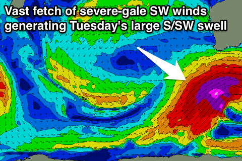
The strongest of the systems now looks to fall just within our southern swell window, with an initial small polar front creating an active sea state for a broad and elongated fetch of severe-gale SW winds to move over.
This will produce a very large swell for South Australia, smaller but still large across our South West into Tuesday.
A late kick in size from the initial front is due Monday with the large swell peaking Tuesday to the 12ft range across swell magnets in the South West with Perth seeing 2-3ft sets. Winds look to linger onshore from the SW, offshore further north.
Beyond this a couple of reinforcing S/SW swells are due through the rest of the week but with persistent onshores. More on this Friday.