Large onshore waves for the period

Western Australia Surf Forecast by Craig Brokensha (issued Monday 25th April)
Best Days: Perth Wednesday, Friday and Saturday mornings, protected breaks in the South West Saturday morning.
Recap
Workable clean waves early Saturday morning with a NE offshore and easing 3-5ft waves across the South West, tiny further north.
Sunday was poor with small amounts of swell and onshore winds, while today a large stormy W/SW swell is on the build, jumping from 6-8ft in the South West and 2ft around Mandurah (1-1.5ft Perth) larger into this afternoon and to 8-10ft in the South West (3ft in Perth).
This week and weekend (Apr 26 – May 1)
The swell from the intense mid-latitude low that formed over the weekend is due to peak this afternoon/evening, easing back into tomorrow.
A secondary front pushing up into us today and tomorrow should produce a reinforcing moderate to large sized W/SW swell for the afternoon.
Margs should hold around 8ft on the sets all day with 2-3ft waves around Perth, easing back from 6ft+ and 2ft respectively Wednesday morning.
Unfortunately conditions will remain poor with gusty W/NW tending SW winds tomorrow, easing from the SW Wednesday across the South West, Perth and Mandurah should see better E/SE offshores.
From Thursday some new SW swell is due to build as a couple of cold fronts are directed up and into us.
The first will generate a fetch of SW gales, generating a moderate to large sized SW swell, building Thursday and peaking Friday morning. A secondary slightly stronger system will then push up on the active sea state of the front before it, producing a fetch of severe-gale S/SW winds through our southern swell window.
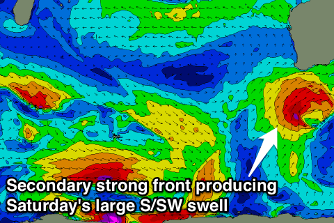 A larger S/SW groundswell is due to peak Saturday from this system.
The first pulse should kick to 6-8ft later Thursday and hold same size Friday morning across the South West, with 2ft+ waves in Perth Friday.
The secondary S/SW groundswell for Saturday should provide larger 8ft+ waves across the South West, but remain around 2ft around Perth with the southerly swell direction.
Conditions will become poor again Thursday with a fresh W/NW tending SW breeze and then SW winds Friday (E/NE offshore around Perth). Winds should swing more S/SE Saturday morning across the South West (SE Perth) favouring protected locations.
As the swell eases Sunday onshore winds from the W are due to develop across the South West again, with E'ly offshores further north.
Longer term we're looking at a strong node of the Long Wave Trough moving into the Bight and stalling next week. This will direct a series of vigorous fronts up through our southern swell window with some large S/SW groundswell on the cards for Tuesday/Wednesday next week, but more on this Wednesday.