Swell magnets for the weekend, better swell Tuesday but with average winds

Western Australia Surf Forecast by Craig Brokensha (issued Wednesday 17th February)
Best Days: Saturday and Sunday mornings at swell magnets in the South West, Wednesday morning in the South West
Recap
Bumpy small waves in the 3ft range each morning across the South West yesterday and today, improving during this morning as winds shifted more E/SE. Perth and Mandurah have remained tiny.
This week and next (Feb 20 - 26)
We should see some better 3-4ft sets across the coast this afternoon with a slight uptick in SW groundswell and the cams are currently showing sets to this size.
This swell is due to ease back through tomorrow from 3ft and winds look great and offshore from the E tending E/NE ahead of afternoon sea breezes.
Perth and Mandurah will remain tiny but clean.
The swell will continue to ease through Sunday and winds look good and light offshore from the E/NE again ahead of an afternoon S/SW change as a surface trough drifts in from the west.
Into Sunday afternoon the first and smallest/least consistent of two SW groundswell pulses are due across the coast.
The inconsistent groundswell was generated by a vigorous but distant polar low to the south-west of Heard Island and should kick late Sunday to 3-5ft, peaking Monday morning around the 4-5ft range.
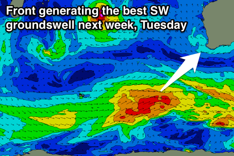 The secondary swell has now been upgraded, with a strengthening polar front moving through our south-western swell window this evening and tomorrow due to provide a better 4-6ft groundswell possibly showing on dark Monday but more so Tuesday morning.
Perth isn't due to see much above 1ft+ Monday, with Tuesday offering better 1-1.5ft sets.
The only issue with Monday and Tuesday are the winds, with S/SW breezes due Monday and S/SE Tuesday (SE around Perth).
Wednesday should see offshore E'ly winds kick back in but with easing levels of swell from 3-4ft or so.
Further on a strong polar frontal progression is due to fire up a little too late and east in our swell window to generate any decent size for us later next week.
This will result in small surf ending the week, with nothing significant also due into the weekend.
Longer term besides some small W/SW swell from the remnants of Tropical Cyclone Uriah being absorbed into the westerly storm track, there's still nothing major on the cards. More on this Monday though. Have a great weekend!