Good options in the South West Sunday morning, more swell next week but with average winds

Western Australia Surf Forecast by Craig Brokensha (issued Friday 18th December)
Best Days: South West Sunday morning, protected breaks later next week
Recap
A good sized swell in the South West to 4-6ft yesterday but fresh S/SE winds limited the best waves to protected spots. Mandurah saw a touch more size to 1-1.5ft, while Perth remained around 1ft.
Today the peak in better W/SW swell has been seen with early favourable winds and clean 4-6ft waves continuing across Margs with better 1-2ft sets to the north. Winds swung onshore quickly though, with poor conditions seen into this afternoon.
This weekend and next week (Dec 19 - 25)
A drop in swell with poor S'ly winds is due tomorrow as an intense mid-latitude forming off the south-west tip of the state encroaches on us.
This low should produce a moderate sized S/SW groundswell for the South West Sunday morning peaking to a good 5-6ft across exposed breaks, if not a touch bigger, while Perth will struggle to get above 1-1.5ft.
Winds are looking great and offshore from the E (E/NE around Perth) but get in early for the most size.
Come Monday the swell will be fading from a small 2ft+ or so across swell magnets with a morning E/NE offshore.
Clean conditions are again due into Tuesday but with no decent size through the morning, and only a slight kick in inconsistent background SW groundswell through the day.
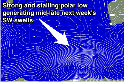 Of greater importance are better and larger pulses of SW groundswell due from Wednesday through Friday as a result of a strengthening node of the Long Wave Trough pushing in from the west and across us during early to mid-next week.
A vigorous and slow moving polar low is forecast to develop, producing an initial fetch of W/SW gales before stalling and continuing to aim a fetch of gales over the same area of ocean and then pushing up towards us through Wednesday and Thursday.
This should result in an initial pulse of fun SW groundswell for Wednesday, building to 6ft+ through the day in the South West and 1-2ft late in Perth, holding a similar size Thursday as a result of the low stalling, and then kicking for a final pulse Friday to the 6-8ft+ range into the afternoon. Perth should continue at 1-2ft through Thursday before kicking to 2ft+ through Friday afternoon.
Unfortunately winds aren't looking the best for this swell event due to the stalling nature of the low and then subsequent front pushing up and into us.
This will result in freshening S/SW winds Wednesday, persisting from the SW Thursday then swinging more S'ly Friday. We'll have a closer look at this and the surf size on Monday though. Have a great weekend!