Good swell with workable winds tomorrow, easing and a touch better Friday morning

Western Australia Surf Forecast by Craig Brokensha (issued Wednesday 11th November)
Best Days: Thursday, Friday morning, Saturday morning, Monday morning, Wednesday morning
Recap
Great morning of waves across the South West, with a solid easing swell from the 6ft range with morning offshores before stronger sea breezes kicked in. Perth and Mandurah dropped back from 2ft or so.
Today smaller bumpier surf was seen across all locations with S'ly winds and easing 4-5ft waves in the South West with 1-2ft waves around Perth.
This week and weekend (Nov 12 - 15)
Tomorrow's large kick in SW groundswell is on track, with the South West due to build from 4-5ft or so early to a larger 6-8ft+ across exposed breaks into the afternoon, while Perth should kick to 2ft to occasionally 3ft through the mid-late afternoon
Conditions should be good but not perfect tomorrow morning with SE winds across the South West, possibly E/SE at times, with better E/SE offshores around Perth ahead of fresh to strong S/SW sea breezes.
Friday is likely to see similar winds (more likely E/SE around Margs), best around Perth as the swell eases from 6ft+ and 2ft+ respectively.
Into the weekend the swell should continue to ease, with Saturday morning being the best with morning E/NE offshores, and afternoon W'ly breezes, with unfavourable S/SW winds Sunday (possibly S/SE around Perth but the swell will be tiny).
Next week onwards (Nov 16 onwards)
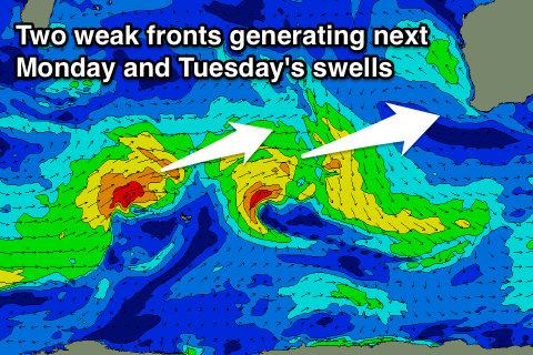 A couple of small to moderate mid-period W/SW swells are due early next week, the first for Monday morning and the second Tuesday morning.
These will be generated by weak mid-latitude fronts pushing through the Indian Ocean over the coming days and weekend.
While not strong they will be persistent, with a fun pulse Monday morning to 3-5ft across the South West, with morning offshores, while Perth only looks to come in at 1ft. Tuesday's swell looks to be a touch stronger to 4-5ft and 1ft+ respectively, but the system generating this swell will strengthen while pushing into the south-west of the state on Tuesday kicking up a closer-range SW windswell to 4-6ft or so into the afternoon but with SW winds.
Perth should also see more size, building to 1-2ft and then easing from a similar size Wednesday morning with better SE winds.
Longer term there's nothing significant until next weekend, but we'll have a closer look at this on Friday.
Comments
Looks like the expected swell is kicking in hard. Been watching a tow team on the bommie.. some solid sets pushing through, easy 6-8ft (though very inconsistent).
https://www.swellnet.com/surfcams/margaret-river