Fun week of waves, best tomorrow and Thursday

Western Australia Surf Forecast by Craig Brokensha (issued Monday 19th October)
Best Days: Tuesday morning, Wednesday morning, Thursday morning, Sunday morning, Monday morning
Recap
A good SW groundswell filled in Saturday morning with offshore winds, 6-8ft sets across the South West and 2ft sets around Perth. Afternoon sea breezes limited the best waves to protected spots.
Sunday was a write-off with Saturday's swell dropping away rapidly as onshore winds kicked in.
Today a strong pulse of new W/SW groundswell has again offered large 6-8ft waves across the South West, with the odd bigger bomb, and 2-3ft waves around Perth after starting off a little slow. Onshore winds created poor conditions though across the South West, with cleaner surf to the north.
This week (Aug 20 - 23)
Today's strong kick in W/SW groundswell will ease back through tomorrow but with much cleaner conditions under light offshore winds across both regions. Margs should ease from 4-6ft through the morning with fading 2ft sets across Perth. Get in during the morning though as sea breezes will develop into the afternoon.
A reinforcing SW groundswell is due into Wednesday morning, with a late kick in stronger SW groundswell, peaking Thursday morning.
The reinforcing groundswell was generated by a healthy fetch of pre-frontal W/NW gales over the weekend and should come in at 4-5ft across the South West and 1ft to occasionally 2ft in Perth.
The secondary stronger SW groundswell pulse is currently being generated by a broad and strengthening polar frontal system to our south-west, aiming a fetch of W/SW gales towards Victoria.
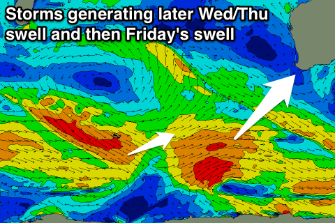 This should produce a fun SW groundswell kicking to 5-6ft later in the day in the South West and easing from a similar size Thursday morning. Perth isn't expected to any size Wednesday with Thursday possibly seeing 1ft to occasionally 2ft sets continuing.
Conditions will be great for these swells with offshore E/SE winds around Margs and E/NE winds up around Perth ahead of afternoon sea breezes and then similar winds Thursday.
Into Friday a reinforcing SW groundswell is due, under the size of the previous pulse, generated by a fetch of pre-frontal polar W/NW gales behind the system that's currently south-west of us. This should keep 3-5ft sets hitting the South West Friday morning but not really influence Perth with tiny 1-1.5ft sets.
Winds are due to go onshore as well as a small trough developing off the coast drifts east, bringing SW winds to most regions.
This weekend onwards (Oct 24 onwards)
Background levels of SW swell are due through the weekend and early next week from patchy and weak polar frontal activity through our swell window.
Size looks to be limited to 3-5ft or so in the South West and 1ft+ around Perth with less than ideal S/SE winds Saturday and better offshores from Sunday morning. Longer term there are hints of a better SW groundswell Thursday week, but we'll have another look at this Wednesday.