Pumping surf from Sunday

West Australian Surf Forecast by Guy Dixon (issued Friday 18th September)
Best Days: Sunday, Monday, Tuesday
Recap:
Nice clean conditions and a modest sized swell yesterday across the South West. Sets at Margs were in the 4ft range with light easterly winds tending north/northeast, but still workable in the afternoon. It was inconsistent at times, but the sets looked great when they came through.
We’ve seen a touch more size this afternoon, with sets more in the 4-5ft range. Again, consistency left a bit to be desired, but when the sets came through this morning they looked fun under light offshore breezes. Winds have since swung light southwesterly, but it’s still workable, particularly at more protected corners.
Perth and Mandurah offered clean 1-2ft peaks throughout the morning, losing a little bit of shape in the afternoon as winds swung light onshore. It was a similar scenario this morning, with weak and inconsistent surf in the 1-1.5ft range for Metro beaches, with a light south/southwesterly flow creating a few subtle bumps on top. Nothing too serious, but nothing flash either.
This weekend (Saturday 19th - Sunday 20th):
The surf will build throughout Saturday steadily to the 6-8ft range across the South West generated by southwesterly gales working on the Indian ocean in previous days. Perth and Mandurah will be in the 2ft (maybe 2ft+) range by the late session, however much of the day will be plagued by winds, making protection crucial.
First thing, winds will be fresh from the south limiting options to the protected spots. As the day wears on, winds will ease ever so slightly, and tend south/southeasterly. There will be options, just don't bother with the exposed spots - wait till Sunday.
Core winds within a southwesterly captured fetch moving east of Heard Island today have been recorded up around the 50kt range.
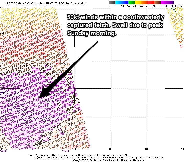
As this system continues on its northeasterly trajectory, it will work on the swell that it has previously generated despite winds weakening. The swell generated by this system will peak on Sunday morning, not quite as big as previously anticipated, but still solid in the 10ft range with a few 12ft sets occasionally. Timing wise, it’ll be pumping by day break with light easterly breezes first thing across the South West tending moderate south/southeasterly later. As for Perth and Mandurah, the surf will be in the 2-3ft range under light southeasterly breezes, gradually swinging round to the south/southeast in the late afternoon.
Keen.
Next week (Monday 21st onward):
The swell will ease to the 6-8ft across the South West and 1-2ft for Perth/Mandurah throughout Monday morning preceding a second solid pulse late in the day.
A complex low and front moving over the Heard Island region today (with core prefrontal winds of 50 knots already showing) will move west over the coming days while intensifying. Unlike the previous system, it won’t be a captured fetch, but core winds look stronger and it will be acting on an active sea state so 8-10ft surf for the South West is not out of the question late on Monday, with the potential for bigger sets (probably peaking under the cover of darkness). Metro beaches are likely to bump back up to the 2-3ft range.
Most of the day will be great, with light easterly winds prevailing across all coasts throughout the day, only tending very light southerly in the late afternoon.
Tuesday will continue to see plenty of residual energy off the back of this system, fading to the 4-6ft range across the South West by the afternoon and to 1-2ft for Perth and Mandurah. Conditions will remain workable under light/moderate northeasterly winds across all coasts (gustiest in early afternoon), lightening and tending northerly/variable in the evening.
After easing throughout the morning to around 3-4ft, Wednesday afternoon will see a subtle period pulse from poorly aligned northwesterly pre-frontal energy, but not much in terms of size. Perth and Mandurah will drop back to the 1ft range, however Thursday afternoon will see a second slightly stronger pulse whipped up by a low that is forecast to move south of Heard Island on Sunday.
Size wise, it won’t be anything ground breaking. The South West will jump to the 4-6ft range, while Perth and Mandurah will pick up 1-2ft peaks. It won’t be a great day of surfing with gusty northerly wind forecast right along the WA coast tending northwesterly in the afternoon.
Further Ahead:
Looking longer term, next weekend should see the surf build into the 6ft range for the South West, with early indications of light favourable winds. We will get the situation pinned down a bit better next week.
Comments
Check this grab from the Yalls surfcam.. it ain't small in WA this morning. Unreal forecasting by Guy - nailed this morning's conditions.
This swell came in bigger than forecast by a lot if the nat buoy is correct
Agree, buoy kicked hard!
Big Sunday again !
Ben he did nail it ! Bettered the other sites as well did
Sept continues to pulse guy I have watched the last 3 sun swells closely & found it hard to pin the size with 2 big ones over 4.5 m they both punched above & the last sun still producing as forecast . Swellnet has proved good and outcast the rival sites
Thanks Caml - great feedback, really good for Guy too - he's only been with us a few months but Craig's been training him well :)