Fresh swell mid-week with offshore breezes, large swell on track for the weekend

West Australian Surf Forecast by Guy Dixon (issued Monday 31st August)
Best Days: Wednesday, Sunday, Monday, Tuesday.
Recap:
The weekend was a shambles with fresh/strong onshore winds shutting down any chance of scoring a good wave. There was no shortage of size across the South West, with Saturday seeing sets in the 6ft+ range, with the odd 8ft set on dark. Sunday saw the surf build into the 8-10ft range, but again, conditions were terrible under a fresh onshore flow.
Perth and Mandurah picked up peaky short range 2-3ft surf, but those onshore breezes chopped it up and there were no decent options on offer.
The surf is currently on the downward trend. Margs was in the 6-8ft range this morning under howling onshore winds but has eased more into the 6ft range this afternoon. Perth and Mandurah are seeing a similar story, with the underlying groundswell diminishing, leaving just short-range 2-3ft wind swell.
This week (Tuesday 1st - Friday 4th):
The downward trend off the back of the weekend’s large swell event will continue with a lack of fresh swell until mid-week. Tuesday will see the surf ease back to 4-6ft for for the South West, while Perth and Mandurah see the surf fade to 1-2ft.
Winds aren’t really showing any sign off easing though, with fresh southerlies forecast all day across the South West. Metro beaches will be under a workable light/moderate southeasterly flow in the morning, improving as winds ease slightly in the afternoon .
Wednesday will be another day of easing swell, dropping back to 3-4ft for the South West and 1ft for Perth and Mandurah, however winds are looking to finally become workable. The South West will be under a light east/southeasterly first thing, holding throughout the day, potentially tending southeasterly in the evening. As for the Metro beaches, east/southeasterly breezes will persist all day leading to clean conditions.
Thursday will see the next pulse of groundswell which will be generated by a westerly fetch moving east of Heard Island today (observing 50kt winds). A growing period pulse will impact the South West on Thursday morning causing the swell to build into the 6-8ft range in the afternoon.
Winds are looking good in the morning for the South West, east/northeasterly first thing, tending northeasterly but workable throughout the day. If you’re keen to head south, winds will be northeasterly and offshore throughout much of the day before swinging light northwesterly late.
Perth and Mandurah won’t pick up too much size off this system as it’s situated quite far south, but will pick up a few 1-2ft peaks. Winds up along the Metro stretch will be east/northeasterly early, tending light northerly and eventually light onshore by the late afternoon.
A cut-off system looks to develop offshore on Friday, however looks to be positioned too far offshore and moving southeast too quickly to provide any noticeable swell for the mainland, however we will monitor this system in coming forecasts as Perth and Mandurah love local systems.
This weekend (Saturday 5th - Sunday 6th):
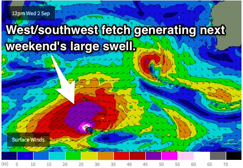
Saturday is looking at the arrival of a strong, long range pulse of southwesterly groundswell generated by a frontal progression west/south of Heard Island. The long period forerunners look to arrive late on Saturday, with the bulk of the swell filling in on Sunday. The surf should jump to the 10-12ft range on Sunday across the South West, and 3ft for Perth and Mandurah.
This system is looking to coincide with a building ridge of high pressure over WA, so winds will be lighter than what we saw this last weekend that just passed.
Saturday will be under an easing southwesterly breeze across the South West and metro stretch.
At this stage, Sunday is likely to see a light west/southwesterly breeze throughout the day, with some models showing winds to tend northwesterly in the afternoon across the South West. In either scenario, winds in the morning are looking light enough to be calm/variable with clean conditions (assuming the scarring settles from the day before).
As for Perth and Mandurah, winds should be similar, light southwesterly (potentially variable offshore for the early session), easing in the afternoon.
It’ll be better to wait for a few more model runs to see if they come into align before making the call.
 Next week (Monday 7th onward):
Off the back of this large swell, conditions will slowly ease with little to no indications of a fresh groundswell until mid-week.
Monday is definitely worth keeping an eye on with plenty of residual size and a ridge hanging over the region leading to light and potentially variable winds. Tuesday will see the surf ease further more, with winds still light and workable.