Swell to come with windows of cleaner conditions

Western Australia Surf Forecast by Craig Brokensha (issued Monday 6th July)
Best Days: Wednesday protected spots, Thursday morning, Friday protected spots in the South West, Saturday morning in the South West, Sunday
Recap
Onshore poor waves in the South West Saturday with cleaner conditions and an inconsistent 1-2ft of swell around Perth. Sunday was cleaner in the South West but still far from perfect, while Perth was a small clean 1-2ft again.
This morning the weekend's swells were easing with dawn offshores giving way to a freshening W/NW breeze around Margs, while Perth was a peak 1-2ft with a light morning offshore again.
This week (Jul 7 – Jul 10)
The first pulse of inconsistent but large W/SW groundswell is due to build tomorrow but with poor W/NW tending SW winds across the South West and all day W'ly breezes around Perth.
Margs should build to an inconsistent 8-10ft or so late in the day, with a secondary pulse through Wednesday to a similar size. Perth looks to build to 2ft, and peak Wednesday to 2-3ft before easing into Thursday. The North West should build to an inconsistent 6ft to occasionally 8ft sets through Wednesday afternoon.
Winds Wednesday will improve but still only look good for protected spots with a strong S/SE tending SE breeze. Thursday morning will be much cleaner with light offshore breezes before a weak W/NW'ly develops in the South West, and S/SW sea breezes kick in around Perth.
Into Friday a reinforcing SW groundswell is due, generated by a pre-frontal fetch of W/NW gales to our south-west over the coming days.
This should keep the South West topped up with 4-6ft sets, with 1-1.5ft waves in Perth and no real size due in the North West. Conditions will be best around Perth with a straight offshore, while Margs is expected to see improving conditions as a SE change moves through after dawn and persists into the afternoon.
 This weekend onwards (Jul 11 onwards)
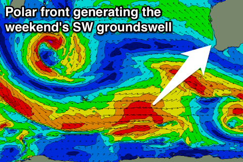
A temporary low point in swell activity is due Saturday morning with offshore E/NE winds ahead of new SW groundswell into the afternoon. This will be generated by a polar front projecting up towards us from below Heard Island from tomorrow through the end of the week, generating a good SW groundswell pulse.
Margs should build to 6ft+ with Perth pulsing to 2ft late in the day, and the North West building to 3-4ft or so Sunday afternoon. Winds will tend more N/NE around Margs Saturday afternoon, but remain favourable around Perth, with E/NE tending variable breezes as the swell eases Sunday.
Longer term a new S/SW groundswell is due early next week, with some better SW groundswell energy later, but we'll have a closer look at this Wednesday.