Large and generally onshore week

Western Australia Surf Forecast by Craig Brokensha (issued Monday 1st June)
Best Days: Gero most mornings, Perth early Thursday and Friday, possibly Margs Friday morning, next week
Recap
Easing swell all weekend with clean conditions each morning, favouring exposed breaks around Margs and Gero. A slight lift in size this morning but with deteriorating and strengthening NE tending N'ly winds.
 This week (Jun 2 - 5)
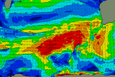
With the first week of winter, we've got our first real dose of large stormy swells with onshore winds on the cards.
A strong node of the Long Wave Trough is moving in from the west, bringing with it a series of vigorous frontal systems.
Firstly a small and relatively weak front is due to move in this evening, bringing with it an increase in low quality W'ly windswell tomorrow.
Behind this though, an elongated fetch of gale to severe-gale W/SW winds should produce a large W/SW groundswell for Wednesday afternoon, Thursday and Friday. Before this swell arrives though, the front proper will push through on Wednesday bringing with it large amounts of close-range W/SW swell but along with fresh to strong onshore winds (more variable each morning around Gero)
Size wise Margs should come in around the 8-10ft range from Wednesday through Friday morning with 2-3ft waves in Perth and 4-5ft+ waves up at Gero.
Small windows of cleaner conditions may be seen around Perth, with a possible early NE'ly Thursday and then then a definite offshore breeze from the E/NE Friday morning. Even Margs may see a N/NE breeze Friday morning but options will be limited with the large easing swell.
Next weekend onwards (Jun 6 onwards)
The Long Wave Trough will move further east and below the south of the country into the weekend and next week, resulting in the frontal activity settling down while winds improve.
Still, we should see plenty of SW groundswell energy across the state as some trailing strong and broad polar fronts push east through our swell window.
These pulses are due over the weekend, the strongest on Sunday to 6-8ft+ in the South West through the afternoon and 2-3ft around Perth and 4-5ft around Gero Monday morning.
Another similar pulse is then due later Monday afternoon, holding Tuesday before easing slowly through the afternoon and further Wednesday.
Winds are still looking dicey Saturday but then more variable Sunday in the South West, ahead of one more onshore day Monday before swinging offshore from the E/NE Tuesday.
Further north, winds should be lighter, but we'll have a closer look at this on Wednesday.