Poor and onshore, good clean south swell Wednesday

Western Australia Surf Forecast by Craig Brokensha (issued Friday 15th May)
Best Days: Tuesday, Wednesday, Thursday, Friday, Saturday week
Recap
Small mix of fading SW swell and N/NW windswell across the South West yesterday with fresh NE tending N/NE winds, while further north Perth was tiny and cleaner with the mix of swells.
Today the surf remained poor with a slowly building W/SW swell in the South West and mix of N/NW windswell with N/NE winds. Perth remained tiny with N/NE winds.
 This weekend and next week (May 16 - 22)
The NW windswell due into tomorrow looks to have been downgraded a touch with the fetch of N/NW winds this evening and tomorrow morning not forecast to be as strong as they were.
Instead we'll see today's increase in W/SW swell easing back a touch into tomorrow but steady to 3-5ft in the South West and 1-2ft in Perth with 3ft surf up at Gero.
Conditions will be poor though with a fresh to strong NE tending N/NW winds.
Come Sunday a mix of new building W/SW and SW swell (more so Monday) are due from the backside of the mid-latitude low sitting to our west, as it pushes into us.
Perth should see semi-stormy 2-3ft waves developing through Sunday with fresh W/NW tending W/SW winds. Gero is expected to see more size along with the onshore winds, while the South West should build to 4-5ft before easing from a similar size Monday morning. Winds will remain onshore though and from the SW through creating poor conditions.
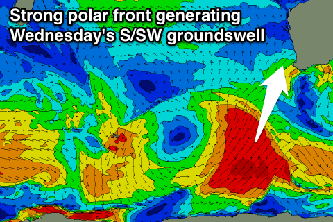
Into Tuesday the swell will ease from the S/SW on the backside of the low but a good new S/SW groundswell is due to build through the day and peak Wednesday.
This will be produced by a strong polar frontal system firing up to our south-southwest over the weekend, projecting a fetch of severe-gale S/SW winds up and towards us Sunday and Monday.
This should see a large S/SW groundswell produced, building Tuesday afternoon to 5-6ft across exposed breaks in the South West before easing from 6-8ft Wednesday morning. The southerly direction will limit the size in Perth with inconsistent 2ft sets due Wednesday morning. Gero should see 3-4ft+ waves Wednesday morning.
Winds will improve from Tuesday and swing offshore from the SE, while Wednesday looks great with fresh to strong E/NE winds across all coasts, easing a touch through the day.
A drop in size is due through Thursday and Friday ahead of a new S/SW groundswell Friday and better pulse Saturday.
These will be generated by less favourably aligned polar fronts firing up in our southern swell window, with the strongest pulse Saturday to produce 4-6ft surf in the South West and 1ft to possibly 2ft waves in Perth. Winds look generally favourable and from the E/NE at this stage, but we'll review this Monday.
Longer term some better S/SW groundswell is due into early the following week from a broader and stronger polar frontal progression, but check back Monday for an update on this. Have a great weekend!