Average week, large swell building through Sunday

Western Australia Surf Forecast by Craig Brokensha (issued Monday 27th April )
Best Days: Friday morning, Saturday morning, Monday morning protected spots, Tuesday morning
Recap
Clean easing swell across both coasts over the weekend, best in the South West as Perth became tiny.
Today the swell bottomed out with small clean 2ft waves in the South West and tiny to flat conditions in Perth.
This week (Apr 28 – May 2)
This week isn't looking too flash with the swell remaining tiny tomorrow with fresh N/NE winds.
Come Wednesday a slight lift in background SW groundswell is due, reaching 3-5ft in the South West and 1-1.5ft in Perth but with poor N/NE tending N/NW winds.
Into the end of the week a couple of better pulses of groundswell are expected. The first for Thursday being the smallest, generated by an intense but small mid-latitude low firing up temporarily to our south-west tomorrow.
This should provide 4-6ft waves across the South West and 1-2ft sets in Perth but with poor N/NW tending SW winds.
A better swell is due Friday from a secondary broader but weaker front pushing in behind the low, projecting a fetch of W/SW gales towards us.
This should generate a larger SW groundswell for Friday, filling in during the day and peaking through the middle of the day to 6ft+ around Margs, 2ft+ in Perth during the afternoon with Gero kicking to 3-5ft late in the day.
Winds should improve during Friday but favouring protected locations with a moderate to fresh S/SE breeze in the South West and better E/SE offshores around Perth and even E/NE up at Gero.
This weekend onwards (May 2 onwards)
Friday's swell should ease back through Saturday but winds look dicey with a S/SE tending SW breeze in the South West and better offshore E'ly winds to the north.
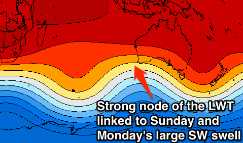
Of greater importance is a large and powerful SW groundswell due into Sunday afternoon and Monday, generated by a vigorous polar low firing up towards us under the influence of a strong node (peak) of the Long Wave Trough.
This polar frontal system will develop in the Heard Island region Wednesday and then push north-east while aiming a fetch of severe-gale to storm-force SW winds up towards us.
A large and powerful SW groundswell will result, building Sunday and reaching 10ft+ in the South West through the late afternoon, kicking to 2ft+ on dark around Perth and 3-4ft up at Gero.
Monday morning should reveal the peak of the swell with easing 10-12ft waves in the South West, 2-3ft sets in Perth and 4-6ft waves up at Gero.
Unfortunately winds will be onshore and fresh from the SW to W/SW Sunday with S/SW winds around Margs Monday morning and better SE winds to the north up at Perth and Gero.
Tuesday will be the day for the South West with variable tending light offshore winds as the swell continues to ease.
Longer term there's nothing as significant on the cards for our region, but we'll review this Wednesday.