Large back to back swells from Wednesday

Western Australia Surf Forecast by Craig Brokensha (issued Friday April 10th)
Best Days: Wednesday onwards
Recap
Clean and glassy conditions across all coasts all day yesterday with the South West offering the only real decent size. Today an onshore change and average mix of swells are breaking across the coast with the rain clearing but remaining showery.
This weekend (Apr 11 - 12)
Give the surf a miss this weekend and focus on the footy. Average amounts of weak windswell are due across the state from the remnants of Tropical Cyclone Ikola forming into a cut-off low to our south, directing a fetch of strong S/SW winds into the South West.
Winds will be onshore and from the S/SW tomorrow and Sunday leaving no quality options.
Monday onwards (Apr 13 onwards)
Monday should see an improvement in conditions with early S/SE winds but there'll be no major swell across the region with an easing SW swell from 3ft or so across exposed breaks in the South West.
Through Tuesday a small and inconsistent increase in long-range SW groundswell is due across the state, but to no major size as the front generating it through the southern Indian Ocean will be relatively weak. Margs should build to an inconsistent 3-4ft+ into the afternoon and 1ft+ sets in Perth. Winds should be variable early but a fresh to strong S/SE change is due into the afternoon across the South West, with afternoon sea breezes around Perth.
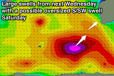
Of much greater importance is the developments heading into the second half of the week.
As has been discussed over the past few update, a strong node of the Long Wave Trough pushing in from the west over the weekend and across us early next week, is expected to bring with it a flurry of vigorous polar frontal activity.
The first system falling under the LWTs spell will be a polar low developing south-east of South Africa tomorrow, producing a fetch of severe-gale to storm-force W/SW winds while tracking east towards us.
A large long-period SW groundswell (a touch more west than true south-west) should be generated, filling in through Wednesday and reaching 8-10ft+ across exposed breaks in the South West into the afternoon and 3ft in Perth later.
The secondary pulse of SW groundswell due from the polar low firing up on the tail of the initial system has been upgraded a touch with the system due to be broader and project with more strength closer to us through next week.
This swell should arrive overnight Thursday and peak Friday morning to a more consistent 10ft+ across exposed breaks in Margs with 3ft sets continuing in Perth.
A steady drop in size is then due through the afternoon and further Saturday but to only be followed by possibly the largest swell of them all, that being an oversized S/SW groundswell.
This may form in the lee of the LWT moving across the south of the country, with a monstrous polar low currently forecast to project a fetch of storm-force SW winds up through WA's southern swell window. We'll have to have a closer look at this development on Monday though.
Back to the conditions expected Wednesday through Friday and Wednesday should see fresh SE tending S/SE winds, with lighter E/SE winds Thursday morning ahead of S/SW sea breezes. Friday could see a period of variable winds before a strong W/SW change moves through linked to the low generating Saturday's large S/SW groundswell. More on this Monday. Have a great weekend!
Comments
i've got 2weeks off.i'm searching for wisdom n advice on indo vs west oz on this run of swell.reading bout an oversized swell got me thinking indo now!i'm seeing a big TD forming off sth sumatra on a long range forecast?they've been way wrong b4!was wondering your thoughts??thnx
If it helps swells are better aimed and bigger for Bali/Sumbawa than Sumatra, but that TC looks to clear in time for the arrival.
Also the largest S/SW groundswell will be real south for Bali and even more S'ly for Ments.
rite on!thnx man.i'll bring u back a bintang singlet!!!!i'll be trolling round the g-land 2 sumbawa region.
Score!! Ha
U havent got of the couch for years daz u dreamer
time for a special guest star appearance!!mid late life crisis!haha
Haha u cant surf g.land daz . Photo evidence a must for us swellnet frends
Daza (troppo whateverer). Just jesting mate . I hope u do go
Same Caml ...
Uppity would love some for us Swellnutters;)
Bring it........On
Big ones especially, Stu, Ben Craig help us Out please, would love to seeeeeee.!
Yeewwwww...
g-land wasnt goin there.u kno that.u cruzn up for another60second barrel??dreamer?
No more long barrells needed dza . Im very keen to get some backhand surfin started . Been enough lefts at my local lately. Many surfers froth about barrells but not me i just wanta go fast. Hate stalling & tryna get tubed by slowing down . Latest forecast is perfect teaser .my addiction to latest forecast is burning credit tooi fast
Anyone got any tips for quitting forecast update addiction ? AA ?
Yeah . Electronic devices don't work in water ;-)
Or just stop looking at forecasts for spots your not a chance
Of travelling to . If you can't get there , they don't exist
Or it's not actually happening . That's what I tell myself
far too often. !
old surf movie 'totally commited'has a quote from mikki dora:when the surf is on its everything.when its not its like it never existed...
Good advice thanks
huge rights!ur credentials speak for themselves.go hard son!
i kinda was hoping ud go west n give some them pro's a free clinic on how to.if its bwt a wildcard really should be on offer 2u....
ok pressures on!i'll try 2 get the shot.havent had the money to give 2the fotogs last few yrs.will slip in an oldie if i come up short.will be out for a visit,was ment to cruz out ur way but after seeing the maps didnt want to sit on the beach n watch!u gonna have 2teach me how to put fotos up?
Ya daz i dunno how to but craigo can help me if need ..
Here ya go Daz.. https://www.swellnet.com/forums/wax/96181
koolman thnx Craig.will investigate n see if can do?.this blogging stuff is hard work!
No more mention of gero and further north in notes?
What about the reporter, is he on holidays it have you lot stopped reporting around here?
Groundswell, our Gero reporter is just doing the reports sporadically from now on, and I'll mention size in the notes when there's a significant swell.