Average period ahead of large clean swell next week

Western Australia Surf Forecast by Craig Brokensha (issued Wednesday April 8th)
Best Days: Thursday morning exposed breaks in South West, Wednesday next week
Recap
Clean fun waves across the South West yesterday and early today with dawn offshores before a fresh onshore change moved through late morning. Perth has been tiny but clean as well each morning.
This week and weekend (Apr 9 - 12)
The background SW groundswell seen the last couple of days in the South West is due to ease back through tomorrow from an inconsistent and small 3-4ft across exposed breaks under morning NE winds that should swing more E'ly through the day as ex Tropical Cyclone Ikola moves in from the north-west.
The NW swell due off TC Ikola still remains minimal with it expected to dissipate to our north-west Thursday with a weaker trough crossing the coast through Friday.
An afternoon increase to 2ft is likely in Perth and 3-4ft in Margs, but with funky and variable winds through the morning and onshore SW winds into the afternoon.
Come Saturday there isn't expected to be any NW swell left with a weaker S/SW windswell from the remnants of Ikola deepening into a cut-off low across our South Coast, aiming a persistent fetch S/SW winds into the South West. A junky and onshore 3-5ft of surf is due, fading into Sunday as winds persist from the SW. Perth will hardly see anything above 2ft, fading through Sunday.
 Monday onwards (Apr 13 onwards)
There's nothing significant for the start of the week with onshores continuing Monday and small amounts of weak swell. Tuesday should be cleaner but small again.
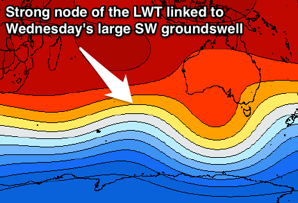
As touched on the last couple of updates, a strong node of the Long Wave Trough is forecast to move through the southern Indian Ocean over the weekend and into early next week, bringing with it a flurry of strong polar frontal activity.
This should project a vigorous polar front from the south-east of South Africa Saturday, above Heard Island and then right under us into Monday evening. Wind speeds will reach the severe-gale to storm-force range generating a large and powerful long-period SW groundswell for Wednesday.
At this stage we're looking at very solid 10-12ft+ surf across exposed spots in the South West (right in time for the start of the Drug Aware Pro), with 3ft+ waves in Perth and 5-6ft+ waves up at Gero.
Winds look good as well as ridge of high pressure moves in from the west Tuesday afternoon and evening, resulting in offshore E/NE breezes. We may then see a secondary large pulse for Thursday but with less favourable NE winds. We'll have a closer look at this on Friday though.
Comments
Fingers crossed Wednesday's forecast stays true!!
Right on cue for the month of april . More guaranteed good surf around margs than any other month in my opinion . So whats going to happen weds , thurs , fri swell wise ? Is it a double pulser ?
go west young man!
You should daz ! I dont need to go west just up the road an hr
First and biggest pulse for Wednesday Camel and then a secondary slightly smaller pulse for Friday.
Firsy probably 10-12ft and second 8-10ft.
Ok yep just gettin the drift now clearer craig .the direction has become more west according to B.w. The pro surfes dont need guns they can get slabbing shacks @ all sorts of diffrent beasts on cape . Why would u invite a comp in autumn . Idiots hey mikehunt !