Good pulses of swell with favourable winds

Western Australia Surf Forecast by Craig Brokensha (issued Monday 16th February)
Best Days: Every morning from Wednesday
Recap
Saturday started off small and onshore across all locations, but a strong new SW groundswell filled in across the South West during the afternoon. Protected locations offered fun ones into the evening as winds eased and tended more S'ly.
Sunday was great as expected with the SW groundswell showing across all locations under morning offshores. Margs was in the 6ft range with 2-3ft waves in Perth and 4-5ft up at Gero.
This morning was also good but windy with a much smaller swell. Sea breezes have since kicked in across the South West and Perth with more favourable SE breezes to the north.
 This week (Feb 17 - 20)
There's been no real change to the inconsistent SW groundswell due across the South West later tomorrow, with locations further north seeing no change in size until Wednesday morning.
A strong and slow moving polar low fired up in the Heard Island region over the weekend and pushed slowly east.
A fun and inconsistent SW groundswell has been produced which should pulse to 5-6ft by dark tomorrow around Margs before peaking overnight and easing from 4-6ft.
Perth should see 2ft sets Wednesday morning with 3-4ft+ waves up at Gero.
Winds tomorrow are expected to be fresh to strong from the SE across Margs, possibly tending E/SE at stages during the morning, with lighter E/SE winds around Perth and SE winds up at Gero. Wednesday morning looks less favourable unfortunately with the positioning of the trough mentioned on Friday now looking to be further east and inland, bringing S/SE winds to all locations. Perth may even see a S/SW'ly from dawn, but hopefully local effects swing it S/SE.
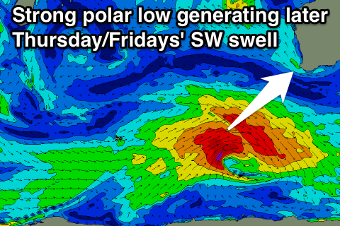
A larger and more consistent SW groundswell on the cards for Thursday/Friday is still on track with a secondary polar low due to develop south-west of us during tomorrow, aiming a fetch of gale to severe-gale W/SW winds through our swell window.
Unfortunately this swell is due to arrive through the afternoon again on Thursday in the South West and late afternoon in Perth, peaking overnight and easing into Friday. Gero should see a peak Friday morning.
Size wise the South West should pulse to 5-6ft+ with 2ft+ sets in Perth by dark Thursday (with onshore sea breezes) while Gero should peak around 3-5ft early Friday. Winds Friday morning look OK but not great with a morning SE'ly across all locations besides Gero which looks to see S/SE breezes.
This weekend onwards (Feb 21 onwards)
The weekend and early next week are looking good for some decent SW tending S/SW groundswell pulses. This will be related to a strengthening node of the Long Wave Trough developing to our south-west and pushing east to the Bight.
This will fire up a strong and slow moving polar low directed mainly towards the South East of the country with an initial strong SW groundswell Sunday due to be followed up by smaller levels of S/SW swell. With the frontal acitivity moving under the country we should see improving winds as well, but we'll review this again on Wednesday.
Comments
Hey Craig we gonna see improvment next week with Perth ?
Swell looks a little more S/SW than ideal so there'll be plenty of 1-2ft waves early in the week then nothing major beyond that.
Ok sweet