Slow period to continue

Western Australia Surf Forecast by Craig Brokensha (issued Friday 28th November)
Best Days: Tuesday morning in the South West, Friday morning in the South West
Recap
Saturday was average across all locations, but into Sunday a new pulse of SW groundswell came in above expectations in the South West with clean 4-5ft+ waves under offshore winds, creating great surf.
Today winds turned back to S/SW across most locations creating average conditions only for desperate surfers.
This week (Dec 2 - 5)
As touched on last update, the outlook for this week is really slow with only a couple of smallish SW groundswell pulses and with less than ideal winds for exposed breaks.
A new SW swell that was expected to build this afternoon to 3-5ft in the South West should drop a back a touch into tomorrow from a similar size. Perth is only due to see 1-1.5ft waves, with 3ft sets up at Gero.
The swell will become smaller Wednesday and bottom out Thursday morning.
Winds will be best tomorrow morning and tend offshore from the E/SE across Margs and Perth through the morning (even possibly E/NE across Perth) while Gero should see SE winds.
Wednesday looks dicey with variable tending onshore winds as a surface trough/low sitting just offshore pushes east and across us. Thursday should see winds go back to the SE across Margs and be more variable around Perth and lighter S/SE up at Gero.
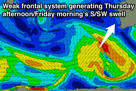 A new S/SW groundswell should build through Thursday and peak Friday morning, generated by a weak polar front pushing up towards us tomorrow and Wednesday. Only a weak fetch of strong to gale-force SW winds are due to be generated in our southern swell window, with the swell due to build to 3-4ft Thursday afternoon and easing from 3ft to occasionally 5ft across exposed breaks in the South West.
Perth isn't due to get above 1ft, while should see inconsistent 2-3ft sets.
Winds will be best in the South West with morning SE winds, while dicey S/SW winds are due north from about Perth.
This weekend onwards (Dec 6 onwards)
There's still nothing significant showing on the long term charts with the westerly storm track remaining relatively subdued.
A couple of SW groundswell pulses are due from Sunday into next week but with no major size above 5ft in the South West and with generally S/SE-SE winds. We'll have another look at this Wednesday though.