Fun Saturday, protected spots into Monday and Tuesday

Western Australia Surf Forecast by Craig Brokensha (issued Friday 19th September)
Best Days: Saturday morning, Monday and Tuesday in protected spots, Wednesday morning, Thursday morning, Friday morning
Recap
Yesterday was less than ideal across most coasts with the swell becoming smaller under average winds.
Today a new SW groundswell has started to fill in with good 6ft sets now hitting Margs, while Perth started tiny but is seeing some bigger sets, but early offshore winds have since swung onshore, with less than ideal N/NE winds in the South West, while Gero is still offshore.
This weekend and Monday (Sep 20 - 22)
This afternoon's kick in SW groundswell should hold into tomorrow morning before easing off through the day. The South West should see 5-6ft+ sets with 2ft+ waves around Perth and 3-5ft sets up at Gero under fresh E/NE tending N'ly winds, so get in early for the biggest and best waves!
Sunday's large kick in inconsistent long-period W/SW groundswell is still on track, generated by a vigorous low moving through the Southern Indian Ocean the last couple of days.
This should build to 8-10ft+ in the South West through the day, 3ft in Perth and 4-6ft up at Gero under poor NW tending SW winds with strength.
The swell should drop back into Monday but a reinforcing W/SW swell is due from the backside of the progression generating Sunday's swell, keeping 6-8ft sets hitting the South West, 2-3ft waves in Perth and 4-5ft surf up at Gero.
Winds will be better but only for protected locations with a fresh and gusty S'ly airstream across most locations (likely tending S/SE in areas like Margs and Perth through the morning.
Next Tuesday onwards (Sep 23 onwards)
Monday's reinforcing W/SW swell is expected to dip away through Tuesday and winds will be OK with a light S/SE'ly around Perth and Margs, fresher from the SE up at Gero.
A low point in swell activity is due overnight Tuesday, with a small increase in SW groundswell due Wednesday afternoon ahead of a much larger and more powerful SW groundswell Thursday.
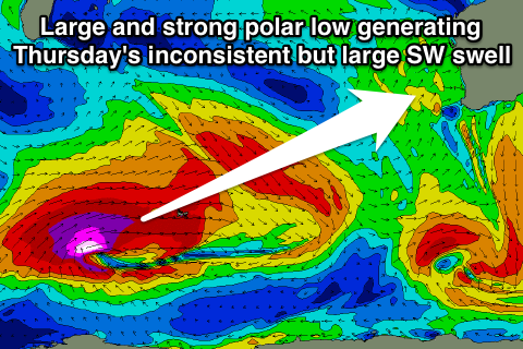 This swell was discussed later last week and will be generated by a vigorous polar low firing up south-east of South Africa (in our far swell window) generating a fetch of severe-gale to storm-force W/SW winds that will be projected towards Indonesia more than towards us.
Still we should see a large and inconsistent SW groundswell generated, arriving Thursday and peaking through the afternoon to 8-10ft+ across exposed breaks in the South West, 3ft in Perth and 5-6ft up at Gero. There'll be very long waits between sets, so you'll have to be patient.
Winds on Wednesday morning before the swell builds will be favourable and offshore across locations north of Margs where an unfavourable W/NW'ly is expected associated with a weak front clipping the state.
Thursday should be good in most spots with offshore E/SE winds ahead of SW sea breezes. We'll confirm this Monday though. Have a great weekend!