Slow period continues

Western Australia Surf Forecast by Craig Brokensha (issued Thursday 14th August)
Best Days: Friday morning, Saturday morning
Recap
The surf's been less than ideal across the coast the last couple of days with fresh to strong NE winds and small to moderate amounts of swell. Today is poor with winds more around to the N'th and an average swell.
This Friday onwards (Aug 15 onwards)
Small to moderate amounts of inconsistent groundswell are expected to pad the coming period, with the strongest pulse due to arrive later tomorrow and peak Saturday morning.
This was generated earlier in the week by a strong but unconsolidated polar frontal progression north of Heard Island.
Saturday morning should see 4-6ft sets out of the W/SW around Margs with 2ft sets in Perth and 3-4ft waves around Gero.
Winds look favourable as a weak change moves through this evening, bringing E/SE winds to the South West tomorrow morning, while Perth and Gero will see a persistent NE'ly. Saturday though should see light variable tending offshore breezes through the morning, probably from the E/NE before swinging NW into the afternoon.
Sunday looks average with a slight drop in size and fresh N/NE tending NW winds.
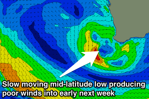 Into next week there's still nothing major on the cards, but moderate and inconsistent pulses of W/SW and then SW groundswell are due across the state. The first on Monday from the W/SW will continue to be met with poor N/NW winds owing to a mid-latitude low stalling off our coast before slowly pushing across us Tuesday.
A better SW groundswell is due on Wednesday but again winds look poor with a freshening W/NW breeze due to a weak approaching cold front.
Longer term there looks to be no real change to the weather pattern, but we may see a larger W/SW groundswell early the following week. Check back here Monday for an update on this.