Pumping weekend of waves across the state

Western Australia Surf Forecast by Craig Brokensha (issued Wednesday 6th August)
Best Days: Saturday, Sunday, Monday, Tuesday
Recap
The surf continued to pump across all locations yesterday morning with offshore winds (hanging in better and longer then expected in the South West) and a large easing SW groundswell.
Today conditions were OK early in the South West but have since deteriorated with a fresh N/NE breeze, while further north, Perth and Gero performed much better.
This week and weekend (Aug 7 – 10)
The surf will continue to ease into tomorrow and winds are looking real tricky as a weakening trough approaches the coast. The weakening nature of the system will likely see onshore winds before dawn weaken and tend variable across all regions, offering glassy OK waves.
Friday looks to play out similar but with less size so it won't be especially good across the state. Use these days to rest for another large groundswell event over the weekend.
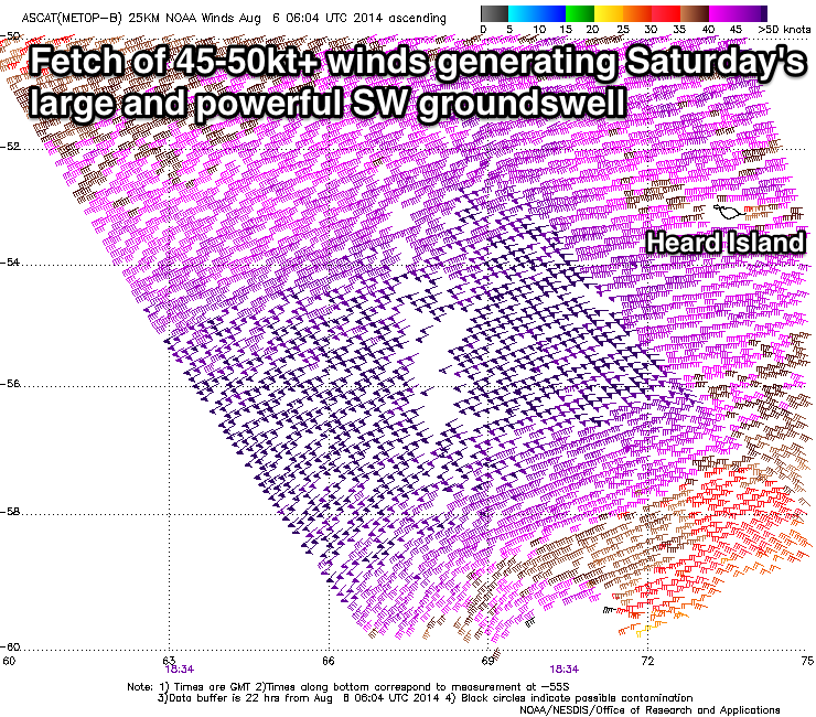 This large SW groundswell started to be generated on Monday as a vigorous polar frontal progression fired up west of Heard Island. Since then the system has moved east, generating a broad fetch of severe-gale to storm-force W/SW winds (right).
The progression should continue east and under us over the coming days while weakening slightly, leaving a large long-period SW groundswell in its wake.
This swell should arrive overnight Friday and peak through the middle of the day/afternoon Saturday with 10-12ft+ surf around Margs, 3-4ft sets in Perth and 6-8ft waves around Gero later in the day.
After the peak a steady drop in size is expected due to the progression being a relatively solitary one but winds look excellent. Saturday morning will be good across selected locations with E/SE winds across most breaks (possibly SE at times around Margs) before swinging more S/SE into the afternoon, but Sunday should see fresh E'ly winds, easing later in the day.
Next Monday onwards (Aug 11 onwards)
Conditions will remain excellent as the swell continues to drop away through Monday, but into Tuesday afternoon a new moderate to large sized SW groundswell is due. No major size above 6ft is due in the South West later Tuesday and Wednesday morning with 2ft sets in Perth and 3-4ft waves around Gero. Late Tuesday is probably the pick with variable winds, while Wednesday looks dicey with N/NW winds. We'll review this again Friday though.
Longer term we should see another large W/SW groundswell later in the week but check back here Friday for an update on this.