Mostly average week ahead

Victorian Forecast by Craig Brokensha (issued Monday June 30th)
Best Days: Friday and Saturday exposed beaches
Features of the Forecast (tl;dr)
- Easing surf into tomorrow morning ahead of a moderate sized, inconsistent SW groundswell into the afternoon
- Stronger, inconsistent SW groundswell for Wed AM, easing into the PM, smaller Thu and Fri
- Light to possibly variable S'ly winds tomorrow, tending moderate through the day
- Strengthening S/SW-S winds Wed, possibly lighter SW across the Surf Coast early
- Mod-fresh but easing S/SE-SE winds Thu, variable later AM
- Small mid-period S/SW swells for Fri/Sat
- Moderate N winds Fri, N/NE-NE into the PM
- Fresh to strong but weakening N/NE-NE winds Sat
- NE tending SE winds Sun
Recap
It was a great weekend of waves across the Surf Coast with building levels of swell through Saturday under all day offshore winds, great yesterday morning as the swell started to settle back down from 3-5ft.
To the east, protected spots offered fun options around the peak of the swell, with conditions deteriorating across both coasts into the afternoon as a trough brought a moderate onshore change.
This morning winds are more variable with average conditions across most spots and a moderate sized, reinforcing S/SW swell in the mix. The quality from the weekend is now a memory.

Great conditions and a decent size on the sets yesterday morning (check Bells)
This week and weekend (Jul 1 - 6)
The coming week will be influenced by local winds rather than swell, with it best approached with lower expectations.
A strong, dynamic low forming off the East Coast will influence our local winds and conditions, with a light to possibly variable S-S/SE breeze due tomorrow morning, increasing a little through the day but remaining only moderate in strength.
This will create lumpy conditions with today’s reinforcing S/SW swell due to ease back to 2-3ft on the Surf Coast with 3-5ft waves to the east.
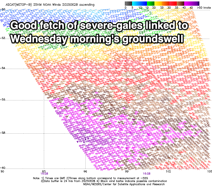
Into the afternoon, our first pulse of new SW groundswell is due, followed by a secondary, slightly stronger increase Wednesday morning.
These swells were generated by a healthy polar frontal progression over the weekend, with a pre-frontal fetch of W/NW gales being followed by stronger, gale to severe-gale W’ly winds.
We should see the first swell building tomorrow afternoon to 3ft+ on the Surf Coast later and 4-6ft to the east, with Wednesday morning’s coming in at 3-4ft and 5-6ft west and east of Melbourne respectively.
Local winds on Wednesday look dicey and generally moderate to fresh S’ly out to sea, with inshore across the Surf Coast possibly seeing a window of lighter SW breezes, but I wouldn’t plan around it. Winds will strengthen through the day, creating deteriorating conditions, with moderate to fresh but easing S/SE tending SE winds due Thursday as the swell eases.
Friday is looking the pick of the week across the exposed beaches under local, offshore N’ly winds, shifting N/NE-NE into the afternoon,
Swell wise, persistent frontal activity along the polar shelf looks to generate small to moderate levels of mid-period S/SW swell, with the best increase arriving later Friday, easing Saturday.

On Friday morning though the Surf Coast looks to be around 2ft+ with 3-4ft sets to the east, increasing a little later and easing from a similar size Saturday morning.
Winds through Saturday look decent for the beaches again, fresh to strong N/NE-N though weakening through the day with weaker NE winds due Sunday morning ahead of weak SE sea breezes.
The surf will be smaller come Sunday, with a long-range SW groundswell likely later but its origins are in our far swell window and it isn’t expected to be overly significant.
Longer term, a significant cold outbreak and frontal progression is due across Western Australia this weekend and early next week, bringing with it building levels of swell later next week. More on this Wednesday and Friday.