Fun Thursday with increasing west swell from Sunday

Victorian Forecast by Craig Brokensha (issued Monday May 2nd)
Best Days: Thursday (afternoon to the east), exposed beaches dawn Friday, Surf Coast Sunday, Monday, Tuesday
Features of the Forecast (tl;dr)
- Strong S winds tomorrow, similar Wed AM but abating through the day
- Small-mod sized mid-period S/SW swell building Wed PM, peaking Thu AM, easing
- Variable NW-N/NW tending N/NE winds Thu
- Strong N/NE winds Fri
- Tiny Sat with strong N/NW-NW winds
- Moderate sized W'ly swell filling in Sun with strong N/NW tending W/NW winds
- Larger W/SW groundswell Mon with fresh N-N/NW winds
- Easing swell Tue with N/NW tending W/NW winds
Recap
It was a great weekend of waves across the Surf Coast with a good pulse of new S/SW groundswell Saturday morning to 4-5ft with offshore winds, easing slowly through the day but still 3ft+ yesterday as more options opened up to the east.
This morning we’re back to a smaller 2ft with winds increasing from the north, favouring selected beaches.
This week and next (Jun 3 - 13)
Make the most of today’s conditions, with winds due to ease off a little and hold from the N-N/NW this afternoon before a trough brings poor, strong S’ly winds from dawn tomorrow.
Now as touched on last week, the coming week isn’t overly special swell wise, with the source of energy building through Wednesday and easing Thursday being a weak polar front moving slowly through our swell window over the coming days.

Weak fetches of W/SW-SW breezes will generate a small to moderate sized mid-period S/SW swell that should build Wednesday afternoon but peak Thursday morning.
The Surf Coast should see 3ft sets with 4ft+ waves to the east, easing through the day and then becoming small Friday. The Surf Coast looks to fade quickly from 2ft with stray 3ft sets to the east.
Local winds still look poor Wednesday as the swell builds, strong but easing out of the S’th, with Thursday looking best on the Surf Coast as winds go variable and tend NW-N/NW. To the east the morning will likely be lumpy but N/NE winds are due into the afternoon, creating improving conditions.
Friday still looks windy, killing off the easing swell with strengthening N/NE winds due ahead of a strong, slow moving mid-latitude low moving in from the Bight.
Winds will remain strong out of the N/NW-NW on Saturday as it nears closer, and as also discussed last week, the initial swell generating properties off this low look average, with it mostly sitting too north of our swell window.
A relatively weak front on the backside of the low moving under Western Australian and through the Bight late week, should produce a tricky, acute W’ly groundswell Sunday, building through the day.
The Surf Coast should build to 3ft+ through the day with 5-6ft sets to the east and winds look strong out of the N/NW tending W/NW through the day.
Now into Monday, a better, larger W/SW groundswell is due, produced by a more southerly positioned and favourable (for swell production) frontal system, with a fetch of strong to gale-force W/SW winds being projected towards us through the weekend.
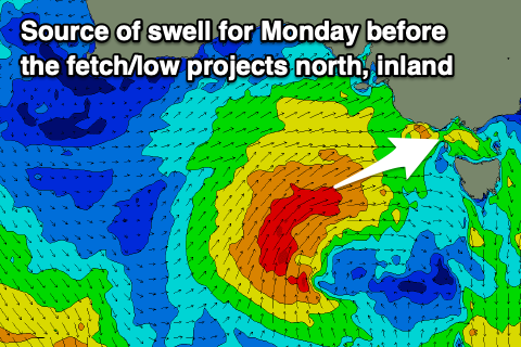
At the very last minute the fetch will project north up into the mainland and what this will do is shave a touch of size off the expected swell but bring favourable N-N/NW winds on Monday, remaining NW tending W/NW on Tuesday as the low stalls west of us.
This will create great conditions along with large 5-6ft waves on the Surf Coast, 6-8ft to the east Monday, easing a little Tuesday.
Check back here on Wednesday and Friday though as this is quite a dynamic outlook with the northward protruding cold outbreak expected to meander a little while bringing a good dump of snow to the alps.
Comments
That was a pretty special Autumn, would take that every year if we could get it. Seemed a fun swell was always around the corner, with some of the most consistently great Autumn weather I can remember
Dx3. Hi pal.
I agree with your comment. The consistency was great as well as the weather.
Last Saturday morning was on the pump and a great way to say by to Autumn and a hello to Winter. AW
First day of Winter on the beaches
Sunday was fun too on the SC reefs with next to no wind, warm sun, favorable tides and fun waves. Not a bad first day of winter that's for sure.