Two windows to target this period

Victorian forecast by Craig Brokensha (issued Friday January 24th)
Best Days: Tomorrow morning Surf Coast, Monday ahead of the late afternoon change
Features of the Forecast (tl;dr)
- Moderate sized mid-period SW swell building through tomorrow, peaking later, easing into Sun AM
- Light W/NW winds tomorrow AM, shifting S/SW around midday and strengthening into the PM
- Stronger SW groundswell filling in Sun, peaking in the PM, easing Mon
- Moderate S/SE-SE winds in the AM Sun, freshening a little later
- Strengthening N/NE winds Mon, tending N/NW early-mid PM ahead of a stronger SW change before dinner
- Strong SW-S/SW winds Tue, S-S/SW Wed
- Moderate sized SW groundswell Wed, easing Thu with S winds
Recap
A new increase in mid-period SW swell was seen yesterday but conditions were average to poor across most locations with nothing to report quality wise across the state.
This morning looks even worse as the swell backs off and onshore winds persist.
This weekend and next week (Jan 25 - 31)
Looking at the weekend ahead and there’s only really one window to target and that’s tomorrow morning on the Surf Coast. A brief respite in the onshore flow should see winds tip light W/NW across the Surf Coast holding until later morning before shifting S/SW and strengthening through the afternoon.
There should be some new mid-period SW swell on the build as well, with the first in a series of swells due to fill in through the day, peaking into the late afternoon/evening.
The source of this first swell was a healthy frontal system pushing in towards us, from the Heard Island region with fetches of strong to gale-force W-W/NW winds, weakening slightly on approach.
We should see moderate sized surf building from 2-3ft through tomorrow morning on the Surf Coast to 4ft on the magnets into the late afternoon with building sets to 6ft+ to the east.
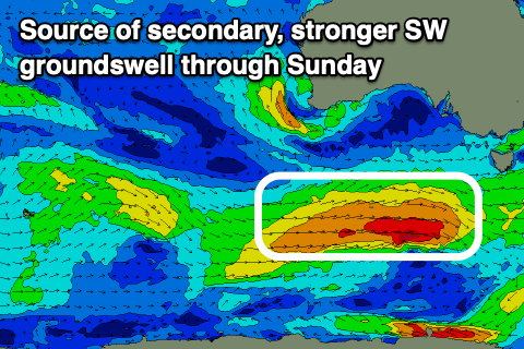
The swell is due to ease temporarily into early Sunday morning ahead of the next increase in SW groundswell through the day, generated by our secondary frontal system moving in quickly on the tail of the first.
This secondary system will again generate a fetch of strong to gale-force winds on top of an active sea state, closer in proximity to us and this should produce a slightly stronger pulse of groundswell to 4ft to possibly 5ft on the Surf Coast magnets into the afternoon and 6ft to possibly 8ft to the east, easing from 3-4ft and 6ft respectively west and east of Melbourne Monday morning.
Looking at the local winds and Sunday isn’t great with moderate S/SE-SE winds through the morning, freshening later afternoon, with Monday still being the pick thanks to strengthening N/NE winds, shifting N/NW into the early-mid afternoon ahead of a stronger, late afternoon SW change.
If you’re looking for less wind, go the early on Monday.
Monday’s change will be linked to a deepening storm to our south-west, and the models have come into agreement regarding the strength and make-up of the system with it looking to be more of a frontal progression rather than tight wound low.
This will see fetches of W/SW-SW gales projected through our south-western swell window, generating a moderate sized SW groundswell for Wednesday but with poor winds (as discussed on Wednesday).
Strong SW-S/SW winds are due in the wake of Monday evening’s change Tuesday, with persistent strong S-S/SW winds Wednesday.
The end of the week looks no better at this stage so make the most of tomorrow morning and Monday. Have a great weekend!
Comments
Onya Señor Brokensha :)
checked this morning at 7am just to test Craig, notes already out, GOATED OS'. Take note Thermal!
Duly noted.
you're a good man thermal.
- Long weekend.
- End of holidays.
- Hot weather.
- Big swell.
Recipe for disaster.
Least the low tide will help.
Hot weather, big swell and long weekend. That seems like a great combo to me. Might drive down from Brunswick with my mates and get amongst it, yew!
BOOM! Hell lets even hire a Kia Carnival or even better a Autotram Extra-Grand by Gospel & Fraunhofer
you have to leave last year to get here this year..
I'll be coming down from Fitzroy in an empty car. Might swing past the Tulla tub and see if there are any tub bros or gals that want to see what real waves are like.
Ed note: Just moved these comments over to a forum thread (otherwise these FC notes will go on for ever).
https://www.swellnet.com/forums/wax/580498
Tell me more about this Brunswick. It sounds like a magical place.
Haha
Talking about Kia carnivals I once tried to winch a guys rented Kia carnival out of a step beach access in fishery bay SA, I asked him what he was thinking going down it and he said I thought there might be bitumen underneath and I replied you drove from port Lincoln for 20km on a gravel road why the fuck would they bitumen the beach access. In the end he had to call a tractor and even that was struggling to pull him out
Haha people’s thoughts amaze me sometimes. Where do they come up with this shit bahahaha
Having said that a Kia Carnival is some specimen of vehicle and highly underrated in my eyes (its amazing how many surfboards you can get in one and still cruise in total comfort)
Probably not the best vehicle to get down said sandy 4wd track with those said 47 surfboards
Maybe the bros from Brunswick can bash a lifeguard or 2 at Gunna on Monday for trying to save their lives.
Doubt the Brunna's would wanna mess up the moustache.. no offence STM3.
On a slightly more pro-Brunswick note, I once ate THE best chicken kebab in history on Sydney rd. Ain't talking kebab stand shite, no. This masterpiece was cooked to order, skewers on the grill, by the happiest, stoked-est, shiniest example of pro-immigration policy I've ever met. Chef's kiss? More like chef's tongue pash. 22 years later I still fantasise about that kebab...
Hi Craigos - what is the confidence level on Sundays swell given last Sundays came “in under expectations”?
Cheers
A lot higher as last Sunday's was a very distant W/SW groundswell and this is a much more reliable, closer-range system and out of the SW.
Onya O’s!!
It is very nice.