Improved wind outlook for early-mid next week

Victorian Surf Forecast by Craig Brokensha (issued Friday March 22nd)
Best Days: This morning, tomorrow morning Surf Coast, Sunday morning Surf Coast, Monday Surf Coast, Tuesday morning Surf Coast, Wednesday morning Surf Coast, beaches next Friday
Features of the Forecast (tl;dr)
- Moderate sized, mid-period SW swell tomorrow with fresh S/SE winds, easing later
- Slightly stronger mid-period SW swell Sun, with a little more size again Mon AM
- Moderate to fresh W/NW-NW winds Sun AM, tending gusty W/SW-SW into the PM
- Large S/SW groundswell building Mon PM, peaking later and into the evening, easing Tue
- Reinforcing, mod-large SW swell Tue AM, easing into the PM and further Wed
- Mod-fresh W/NW-NW tending W winds Mon, NW tending fresh SW into the PM Tue
- W/NW winds Wed AM, shifting S/SW later AM and strengthening into the PM
- Fresh S/SE winds Thu
- Possible NE winds developing Fri AM with a small, building W/SW swell
Recap
The surf has held in the 3ft range across the Surf Coast and to 4ft+ or so to the east the last two days with lumpy conditions to the west yesterday, better this morning. Winds will freshen from the S'th into the afternoon so get in before lunch.
This weekend and next week (Mar 23 - 29)
The current mid-period SW swell will ease into the weekend, only to be replaced by some new mid-period energy, generated by a healthy polar frontal progression, south of the country the last couple of days.
A touch more size is due on today, up to 3ft+ on the Surf Coast and 4-5ft to the east tomorrow, but this afternoon's shallow S'ly change will strengthen into tomorrow, bringing fresh S/SE winds, that will ease into the late afternoon/evening. There's an outside chance of variable winds to the east at dawn but these won't last long.
Winds will shift back to the W/NW-NW on Sunday morning along with a slightly bigger bump of mid-period SW swell energy. Waves to 3-4ft are due on the Surf Coast with 5-6ft sets to the east, building a little further into the afternoon as some localised swell from a front moving through builds. This will be with W/SW-SW change through the afternoon, though not overly strong in nature.
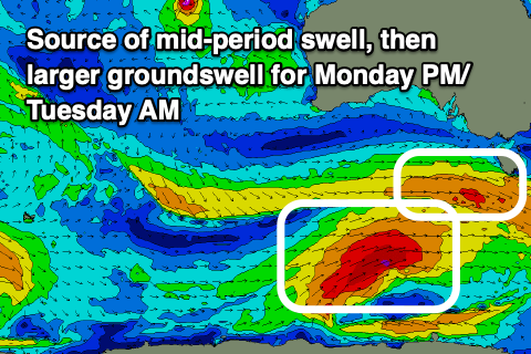
We then look at the larger S/SW groundswell due into Monday afternoon, with a secondary pulse of reinforcing SW swell for Tuesday.
The structure of the polar low and following front linked to these swells has always been a little disjointed, but we're now looking at totally seperate systems.

Firstly, the polar low will form south of Western Australia today, with a fetch of W/SW gales forecast to be projected north-east through our south-western, then southern swell windows over the weekend. Moderate levels of mid-period SW swell are due ahead of the groundswell early Monday, likely to 3-5ft on the Surf Coast, with the groundswell expected to build to 6ft to possibly 8ft into the later afternoon/evening (larger to the east).
This will then ease from the 6ft range on Tuesday, but a secondary, significant frontal system will race in Monday, generating a fetch of gale to severe-gale W/NW winds through our south-western swell window. This should produce an additional mid-period SW swell for Tuesday morning to 6ft on the Surf Coast magnets, easing into the afternoon and then down from 3-4ft on Wednesday.
It's this secondary front that will bring better winds through early to mid next week, with fresh W/NW-NW tending W winds due on Monday, NW Tuesday morning before shifting SW into the afternoon.
Wednesday now looks better as well with a W/NW offshore before shifting fresh S/SW later morning, a touch stronger into the afternoon.
The end of the week still looks poor with fresh S/SE winds on Thursday with a further drop in swell, possibly tending NE into Friday though we'll have to review this on Monday. Size wise a small, mid-period W/SW swell may fill in, though only to 2ft on the Surf Coast and a better 3-4ft to the east.
Longer term the outlook is slow into next weekend and early the following week with no major swell generating systems due within out close to medium-range swell windows. We'll have to rely on distant energy from the south-west of Western Australia. The activity looks to move back in later next week, but more on this Monday. Have a great weekend!
Comments
looks like they'll have to have Bells all wrapped up by Wed
Yes and or wait for some scraps at the end of the period. Real shame monday can’t be included.
Overlapping heats on the cards
why is the automatic forecast not picking it up ?
Looks to be mixing swell directions and going more west than south in the overall forecast.