Poor end to the week, OK on the beaches for the weekend

Victorian Surf Forecast by Craig Brokensha (issued Wednesday March 13th)
Best Days: Today for the keen, beaches Saturday and Sunday mornings, exposed beaches Monday and Tuesday morning
Features of the Forecast (tl;dr)
- Easing SW swell tomorrow with strong S-S/SE winds to the west, moderate in the morning to the east
- Smaller Fri with a building SE windswell thanks to strengthening E/SE-SE winds
- Easing mix of SE windswell and background SW swell with E/NE-NE tending SE winds
- Small, building S/SW swell Sun, peaking in the PM, easing Mon
- E/NE winds Sun AM ahead of sea breezes, NE-N/NE Mon
- Small, background swell Tue with strong N/NE tending S/SW winds mid-late PM
- Moderate + sized W/SW groundswell Wed with strong S winds
- Easing swell Thu with strong E-SE winds
Recap
The swell backed off into yesterday and at dawn, winds were light across most regions but a strengthening onshore change moved through during the day, creating deteriorating conditions.
Today, we've got lingering, moderate to fresh onshore winds and a stronger SW groundswell on the build with sets to 3-4ft on the Surf Coast and 4-6ft to the east. A peak is due this afternoon to 4-5ft and 6-8ft respectively but with no real improvement to conditions. A moderate S/SW-SW breeze is due to linger all day.
This week and weekend (Mar 14 -17)
On Monday I made of note of checking back today for an update on the local wind situation for tomorrow morning, when this afternoon's SW groundswell starts to ease.
Unfortunately the update isn't good, with a surface trough that was due to possibly linger west of us early, bringing W/NW-NW winds, now set to sit further east, bringing strong S-S/SE winds to the Surf Coast, weaker to the east, but strengthening through the day.
Easing sets from 3-4ft are due on the Surf Coast, 5-6ft to the east, smaller Friday and back from 2-3ft and 4-5ft to the east. There'll also be some junky, building SE windswell on the Surf Coast along with strengthening E/SE-SE winds. This looks to reach 3-4ft onto the afternoon on the sets.

As touched on in Monday's update, the beaches will start to improve on the weekend as winds shift E/NE-NE on Saturday morning, and more E/NE Sunday.
Swell wise, a mix of SE windswell and background SW swell are due on the Surf Coast, easing back from 2-3ft to the east and 3ft to occasionally 4ft to the east, smaller early Sunday.
During the day Sunday, a new pulse of S/SW swell is due, generated by a slim fetch of strong to gale-force W'ly winds, very late in our southern swell window. This will likely only produce a small S'ly for the Surf Coast to 2-3ft into the afternoon, 3ft to the east, then easing from 2ft and 2-3ft respectively Monday morning.
Winds will shift more NE-N/NE through Monday, favouring exposed beaches, stronger N/NE on Tuesday ahead of a trough and eventual strong, S/SW change into the mid-late afternoon. Swell wise, some inconsistent background energy should maintain 2-3ft sets to the east, 1-2ft to the west, with some stronger swell due into the middle to end of the week.
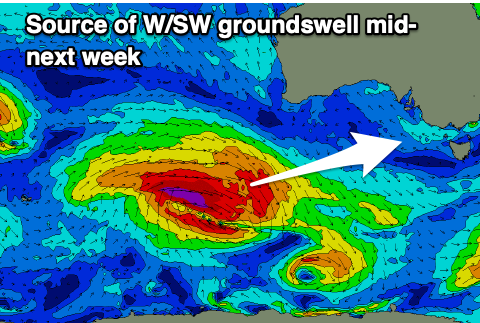
The source of swell for Wednesday will be a strong but slightly disjointed low firing up to the south-west of Western Australia on the weekend, generating gale to severe-galeforce W/NW winds, followed by gale-force W/SW winds.
A moderate + sized pulse of W/SW groundswell with surf to 4ft+ on the Surf Coast, 6ft+ to the east but with strong S'ly winds.
We're expected to see winds shift back to the east through the end of next week as the swell slowly eases, which will favour spots to the east rather than Surf Coast. More on this and a strong, long-range SW groundswell for the weekend on Friday.
Comments
Thanks mate. I’m enjoying the slight tweaks to formatting you’ve made in recent times (bolding days and working wind & waves sequentially through the week). Cheers.
same! like it
Thanks fellas.
Thanks Craig, but can you please throw in more light NW breezes with stronger SW swells.