Dynamic period with plenty of swell and workable winds

Victorian Surf Forecast by Craig Brokensha (issued Monday January 29th)
Best Days: This morning, Surf Coast Thusday morning, Surf Coast early Friday, Surf Coast Saturday morning, Sunday morning
Features of the Forecast (tl;dr)
- Small-mod sized mid-period W/SW swell for tomorrow, easing into Wed AM
- Moderate S/SE winds tomorrow, strengthening into the PM
- Moderate sized W/SW-SW swell building Wed PM, peaking Thu AM
- Gusty S/SW winds Wed, W/NW Thu AM, tending S/SW late AM and freshening
- Slight smaller Fri AM ahead of a large SW swell building late, peaking Sat
- W/NW winds early Fri, shifting strong W/SW-SW into the PM
- W/NW tending SE winds Sat
- Easing swell Sun with strengthening N/NE winds ahead of a SW change
Recap
A good weekend of waves across the Surf Coast with our stronger W/SW groundswell filling in through the day, slow early Saturday but pulsing to a good 4ft with favourable winds for the protected reefs and beaches.
The swell hung in well yesterday morning along with some reinforcing mid-period W/SW swell energy with great conditions through the morning.

Great surf yesterday AM
Today the swell is easing and winds are more variable creating cleanish, though slightly lumpy conditions across both locations. Make the most of the light winds as a strong S/SW change will move in by about midday.

Cleaner to the east this morning
This week and weekend (Jan 30 – Feb 4)
The coming week looks active swell wise thanks to a stream of persistent frontal activity swinging in from the west, under the country but local winds will be an issue apart from a couple of windows later week.
Today's trough will leave moderate S/SE winds into tomorrow morning across the state strengthening into the afternoon, swinging back to the S/SW on Wednesday and remaining fresh.
This will spoil an initial pulse of W/SW swell due into tomorrow, generated by a good fetch of W/NW winds passing under Western Australia on the weekend.
The Surf Coast should persist in the 2-3ft range with 4-5ft sets to the east, easing temporarily into Wednesday morning.
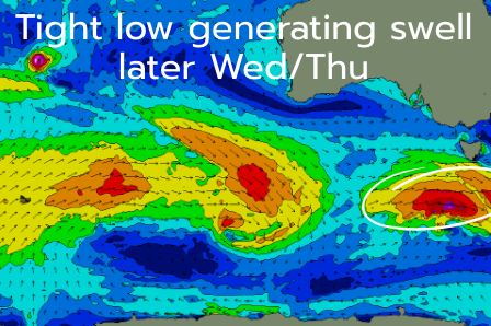
A stronger pulse of W/SW-SW swell due Wednesday afternoon and Thursday is still on track, with it generated by the strongest of the frontal systems passing south of the Bight this evening.
This front is forecast to deepen into a low while moving more through our south-western swell window, generating a fetch of W/NW tending W'ly gales, with embedded severe-gales likely.
The fast movement of the low will limit any major size being generated but we should see the Surf Coast pulsing to 3ft+ later Wednesday with 5-6ft sets to the east, peaking Thursday morning to 3ft to occasionally 4ft and 6ft respectively west and east of Melbourne.
Winds are due to tip more W/NW for a period on Thursday morning as the frontal progression clips the state, reverting back to the SW later morning, with Friday seeing stronger W/SW-SW winds (W/NW for a period in the morning) and a temporary drop back in size.

Later in the day on Friday, a larger SW swell should start to show, generated by a strengthening low on the backside of the stream of activity moving under the country, producing a great fetch of strong to gale-force W/SW winds in our south-western swell window.
At this stage a large SW swell is due, peaking Saturday with what could be light W/NW winds as the system clears to the east, strengthening from the N/NE Sunday ahead of the next swell generating system for early next week.
All in all it's an active period with windows of workable surf from later week. Check back here through the week for updates on how the swell generating storms and winds are evolving.
Comments
what a run craigos! thanks mate
you know he doesn't create the surf conditions?
Go wash your mouth out Kev
Kevin,
That is what we call blasphemy.
May Craigos have mercy on your soul.
Nice forey though Craigos! Woot woot!
Haha.
Haha clearly you haven’t been around these forecast notes long enough kev
Craig = Huey
Sunday and this morning was lots of fun. Saturday a bit underwhelming vs my expectations. Looking forward to the week ahead, can't ask for much more than this for late Jan!
Yay!
"generating a fetch of W/MW tending W'ly gales"
It's been so long you've forgotten where the N key is!
What ya on about ;)
Is W/MW West/More West?
The weekend warriors on the SC will be frothing hard especially after the weekend just gone.. Lots of crew in the water, first glacé at the winki cam Sunday resembled an oil spill. The dramatic abating winds after sunset last week provided nice twilight conditions for a late paddle. - Cheers Craigos - nice lookin forey- Share the froth.
Again love the bolding!
Does feel like Autumn in January - nice!