Tricky winds with distant west swells

Victorian Surf Forecast by Craig Brokensha (issued Monday 4th December)
Best Days: Today exposed beaches for the desperate, Thursday morning for the keen, Friday morning
Features of the Forecast (tl;dr)
- Fading swell tomorrow with light SW winds (W/NW-NW AM Surf Coast), strengthening from the S/SW through the day
- Small-mod sized, inconsistent W/SW groundswell building later tomorrow, but more so Wed, peaking into the PM
- Light-mod SW winds Wed (W/NW Surf Coast), freshening from, the S'th through the day
- Slightly more consistent small-mod sized W/SW swell Thu and Fri with light S/SE-S winds Thu, freshening from the SE
- Variable winds Fri AM, strengthening from the S/SW into the PM
- Small, easing surf Sat with strengthening SW winds
- Small-mod sized weak swell Sun with SW winds, W/NW early Surf Coast
- Moderate sized S/SW groundswell buildng Tue with S winds, easing Wed with E winds
Recap
Average surf through the weekend with smaller waves on Saturday along with gusty onshore winds, weaker and more surfable yesterday but small to tiny.
Today we've got clean conditions on the beaches and some small background SW swell to 2ft across the Mornington Peninsula tiny to the west. Winds will remain favourable all day but with easing size.

Small, clean waves for the depserate today
This week and weekend (Dec 5 - 10)
This morning's small surf is due to fade tomorrow morning, with the swell reaching a low point ahead of some new, inconsistent W/SW groundswell through the late afternoon but more so Wednesday. This will then be followed by some fun, reinforcing mid-period W/SW energy on Thursday/Friday.
A small trough moving through tomorrow is due to bring a pre-dawn SW change that looks to tend variable across the Surf Coast and likely light W/NW-NW but with no surf. To the east the surf will be small to tiny and lumpy.
Strengthening S/SW winds are due into the afternoon and evening as a weak mid-latitude front moves in through the Bight, clipping the state, easing Wednesday but lingering from the S/SW-SW. The Surf Coast is likely to see early W/NW winds before reverting back to the S'th.
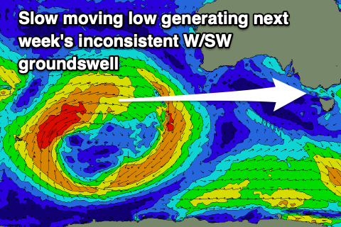
Coming back to the groundswell, and the source was a strong, slow moving but northerly positioned low moving through the southern Indian Ocean late last week. This will result in an inconsistent but fun pulse of W/SW groundswell, arriving later afternoon but filling in more so Wednesday, building to 2-3ft on the Surf Coast magnets into the afternoon and 4-5ft+ to the east. The morning will be smaller, when cleanest, bumpy into the afternoon.
Some more consistent mid-period W/SW swell is due into Thursday/Friday, generated by secondary, much weaker but healthy frontal activity moving in behind the low on the weekend, passing under the country over the coming days.
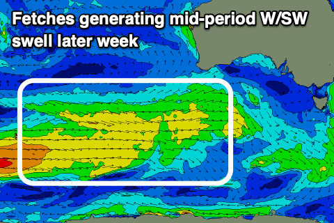
This should see 2-3ft sets persisting on the Surf Coast magnets, 4-5ft to the east, easing slowly through Friday from a similar size, smaller Saturday.
Locally winds look to be a slight issue with light S/SE-S winds on Thursday morning ahead of fresh sea breezes, best Friday morning with more variable winds ahead of a trough and S/SW change later morning.
Unfortunately strengthening SW winds will be seen into Saturday as a high starts to edge in behind Friday's change, though strengthening storm activity on the highs south-eastern flank might see periods of W/NW winds into Sunday and Monday mornings next week, going more S'ly from Tuesday.
These storms will generate some mid-period and groundswell energy ealy next week, with the strongest being a polar low. The groundswell from the low is due to peak Tuesday afternoon but with those S'ly winds, possibly improving Wednesday as the swell eases and winds shift more E/NE.
We'll take a closer look at this Wednesday.