Very dynamic period with a large spike in swell Friday afternoon

Victorian Surf Forecast by Craig Brokensha (issued Wednesday 6th September)
Best Days: Today, beaches tomorrow, Saturday Surf Coast, beaches Monday, Surf Coast early Tuesday
Features of the Forecast (tl;dr)
- Easing mix of swells into tomorrow with strong N-N/NE winds, easing late PM
- Temp low point in swell Fri AM ahead of a large, rapid jump in S/SW swell through the day, peaking overnight
- Strong W/NW tending W/SW then SW winds Fri
- Steady drop in large S/SW swell Sat with fresh W/NW tending stronger NW-N/NW winds
- Small Sun with W/NW tending SW winds late AM
- Moderate sized S/SW groundswell building Mon with N tending NE winds
- Easing swell Tue with NW tending SW winds by mid-late AM
Recap
Clean conditions with an inconsistent but good quality W/SW groundswell on the build yesterday, coming in at 2-3ft through the morning and then reaching 3ft to occasionally 4ft after lunch with with choppy conditions as a strong W'ly change whipped through. To the east there was a small window early before the wind moved in.
Today we've got a mix of mid-period energy and easing groundswell with slow 3ft to occasionally 4ft sets on the Surf Coast magnets, 5-6ft to the east and fresh N'ly winds are favouring the beaches. Winds are due to tend more N/NW on the Surf Coast through the afternoon and flirt from the N-N/NW to the east creating tricky though workable conditions.

Beachy goodness this morning
This week and next (Sep 7 - 15)
The current mix of swells are due to ease into this afternoon and further tomorrow along with strong, persistent N-N/NE winds that look to ease into the late afternoon.
This will favour the beaches again with easing 2ft+ sets on the Surf Coast magnets, 4ft to the east, smaller into the afternoon.
A temporary low point in surf is due early Friday along with strong W/NW winds that will shift W/SW and then SW through the day as a deepening mid-latitude low pushes in and across us.
This low is currently in the Bight and relatively benign but will deepen rapidly while moving across us on Friday, directing gale to severe-gale S/SW winds up and into Bass Strait.
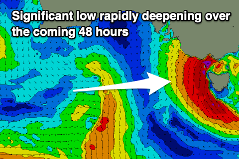
A large, rapid increase in localised swell is due through Friday, more so after lunch and into the evening with stormy surf to 6-8ft likely on dark across the Surf Coast and 10ft waves to the east.
Such is the dynamic nature of this low, the increase in size will be quite rapid.
The easing trend will also be quite rapid as the low moves east on Saturday, cutting off the in-feed of swell generating winds.
The swell looks to still be in the 6ft range early Saturday on the Surf Coast, 6-8ft to the east, but easing rapidly and dropping to 3ft and 4ft+ respectively through the afternoon. Allow some flexibilty on the sizes due to the dynamic nature of the low.
Winds are now looking better Saturday morning as well with a W/NW offshore that will tip more N/NW and strengthen into the afternoon.
This will be ahead of a small trough moving in from the west.
With this strengthening offshore the surf should improve rapidly Saturday, making both Friday and Saturday quite interesting.
Sunday looks smaller and morning W/NW winds will give into a late morning SW change as the trough clips us.

Moving into next week we've got a fun S/SW groundswell due Monday/Tuesday before things go quieter.
A late forming polar frontal progression along the polar shelf, to the south-southwest of Tasmania is expected to produce SW gales through our southern swell window, generating a fun kick in size through Monday, peaking into the afternoon.
The Surf Coast looks to build to 3-4ft later Monday, easing from 3ft+ Tuesday with 5-6ft sets to the east, easing from 4-5ft on Tuesday.
Conditions look favourable as well with local offshore tending N/NE-NE winds on Monday, while a trough may bring a NW tending SW change Tuesday. We'll review this again on Friday.
Following the S/SW groundswell, a large blocking high sitting in the Tasman Sea, stretching out west across the continent looks to bring a small run of surf through the rest of the week. Check back here on Friday for any changes to this though.
Comments
Indian Ocean pumping out great chunks of rain every couple of days like this time last year.
Put tomorrow's low in the Coral Sea and we'd almost be calling it a cyclone!