Coupla OK days this week, ahead of a fun weekend

Victorian Surf Forecast by Ben Matson (issued Monday 8th May)
Features of the Forecast (tl;dr)
- Continuation of poor/average conditions Tues
- Improving surf Wed, mainly west of Melbourne
- Fun waves everywhere on Thurs though rapidly easing in size
- Nice weekend of waves, best suited to open beaches; sizeable east of Melbourne
- Stacks of surf for the following week
Recap
Poor surf for the last three days under a predominantly onshore airstream. Size built to 3-4ft Saturday and Sunday but has eased back today.
This week (May 9 - 12)
No change to the outlook for the next few days.
A swell increase is expected to show overnight that'll boost size to 3-4ft west of Melbourne on Tuesday, however it'll remain bumpy under a moderate to fresh SW airstream. The primary cause for this onshore flow - a large Tasman Low that generated 15-20ft sets across the Sydney coast today - means there's a reduced chance for an early window of light W'ly winds in Torquay, though it can't be ruled out.
Much lighter (though still problematic) onshore winds are expected on Wednesday however it should have weakened enough to allow for topographical influences to come into play west of Melbourne, i.e. an early period of light W'ly winds, along with a plateauing long range groundswell that'll produce inconsistent 3-4ft sets at the Surf Coast swell magnets.
This swell was generated a few days ago by strong activity way out near Heard Island, sitting at low latitudes, so there'll be lengthy breaks between the sets. But it's a worthwhile day to look for waves.
East of Melbourne will be bigger at exposed beaches (4-6ft) and protected spots may be a little undersized here. Keep your expectations low across this region.
Rapidly easing surf through Thursday will be accompanied by light variable/offshore winds, and small fun waves west of Melbourne (2-3ft easing to 1-2ft) but better surf at the open beaches east of Melbourne (3-5ft easing to 3ft).
Surf size will drop more prominently into Friday as winds freshen from the NW ahead of a shallow W'ly change through the day.
So, make the most of Wednesday and Thursday!
This weekend (May 13 - 14)
A blocking pattern is setting up in our swell window, which will be the main cause of the easing trend later this week.
However, there's usually something brewing on the upwards flank of any block, and in this case we have a significant cut-off low forecast to move through the Bight on Wednesday and Thursday. But although very powerful, it will initially be poorly orientated within our swell window (aimed into WA and SA, see below)
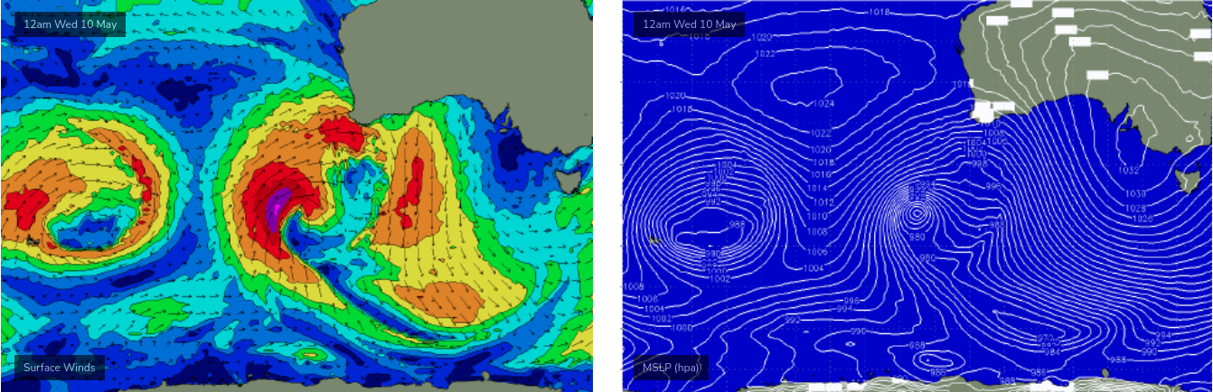
It won't be until late Thursday and Friday that the low will finally enter our swell window, but only as it tracks unfavourably SE, perpendicular through our great circle path, whilst gradually weakening. This means any fetch aimed towards our coast will spend a brief time in a position to generate swell for our region. Furthermore, the position and track of the low will result in more westerly swell direction within Bass Strait, which isn't great for the Surf Coast. This will also result in a much wider variation in size from region to region.
Nevertheless, we can expect a kick in size on Saturday, and fortunately local conditions should be clean with light winds, tending NE if anything. Size should build to a very inconsistent 2-3ft west of Melbourne - the westerly swell direction exaggerating the inconsistency to a level more than we usually see - but east of Melbourne the open beaches should push 4-6ft across the Peninsula and 6ft+ at the Island. So, with good conditions there should be a wide variety of options throughout the state.
Size will then slow ease through Sunday with winds straightening up from the north (without any major strength).
So all in all, the weekend is looking reasonably fun though the best options will be found at open beaches. I'll firm things up on Wednesday.
Next week (May 15 onwards)
The longer term is looking way more mobile for the following week with stacks of strong frontal systems through the Southern Ocean and a truckload of pre-winter groundswell on the make.
More on Wednesday.
Comments
Sorry for the delay.. should be back to normal programming Wed.
Forgiven given what I'm reading
Ben, before doing Wednesday's notes, you need to do an audit of Craig's annual leave! He always seems to be away and/or scoring. Lucky bastard.
Looks like he's getting some fun waves in Japan.
“ The longer term is looking way more mobile for the following week with stacks of strong frontal systems through the Southern Ocean and a truckload of pre-winter groundswell on the make. ”
So not a bad week to be out of action this week then?
Wrap up of recent cold event:
https://www.abc.net.au/news/2023-05-08/may-cold-front-delivers-snow-hail...
a lot of -7 in the report!
"Cooma reached 2.7C on Sunday, its coldest May maximum on record, while Canberra peaked at just 7.8C, its coldest May day in more than 20 years."