Slow period, surf now

Victorian Surf Forecast by Craig Brokensha (issued Wednesday 8th February)
Best Days: Today ahead of stronger sea breezes mid-late PM, tomorrow morning to the east and Surf Coast from mid-morning, keen surfers exposed beaches Saturday morning, Wednesday morning exposed beaches
Features of the Forecast (tl;dr)
- Easing mid-period S/SW swell tomorrow with light E/NE tending weak S/SW winds to the east, tending variable through the morning to the west ahead of a shallow S/SW change
- Small to tiny Fri with mod SW winds, freshening from the S/SW
- Small to tiny Sat with E/NE tending strong S/SE winds
- Strengthening S/SW winds Sun, fresh S Mon
- Inconsistent, small mid-period W/SW swell building Tue, easing Wed
- S/SE-SE winds Tue, NE tending SE Wed
- Fading swell Thu with variable tending S/SW winds
Recap
A small window of lighter winds early on the Surf Coast yesterday morning with the swell still coming in the 3ft range, deteriorating through the day with freshening S'ly winds.
A new mid-period S/SW swell arrived into the afternoon and is holding this morning with 3ft+ waves on the Surf Coast, 4-5ft to the east. Conditions aren't ideal but still fun for the keen across all regions.

Plenty of swell today
This week and weekend (Feb 9 - 12)
Cape Sorell is already on the ease, and with this we'll see the S/SW energy easing through today as winds strengthen from the S/SE mid-late afternoon. Until then winds will remain light to moderate, so get a surf in before then.
Moving into tomorrow we'll see the S/SW swell easing back from 2ft+ on the Surf Coast and 3ft on the sets to the east as winds tend light E/NE east of Melbourne and variable through the mid-late morning on the Surf Coast before a weak S/SW change develops as a trough dips south across Bass Strait.
The trough will linger into Friday bringing moderate SW winds in the morning, freshening through the day while tending S/SW. There's an outside chance for light W/NW winds on the Surf Coast at dawn but there'll be nothing of note size wise.
The swell will bottom out into the weekend and winds should shift E/NE Saturday morning ahead of strong S/SE sea breezes and then strengthening S/SW winds on Sunday as another surface trough deepens while slipping south. There might be a slow 2ft wave on the exposed beaches Saturday, but keep your expectations in check.
Unfortunately the trough will linger Monday, keeping S winds blowing across the coast, shifting S/SE-SE on Tuesday but with no significant swell.
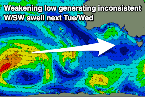
Some small, inconsistent mid-period W/SW swell is due to build Tuesday and then ease Wednesday morning as winds shift NE through the morning, generated by a distant and weakening polar low to the south-west of WA tomorrow. Small 2ft sets are due on the Surf Coast magnets, with 3-4ft sets to the east, but with a long wait for them. Either way, with the clean conditions it'll be worth a surf.
Longer term we should see a flurry of better fronts pushing in and under the country from later next week, generating some fun W/SW swell from next weekend onwards, but more on this Friday.