Get stuck in this morning, then hit the beaches

Victorian Surf Forecast by Craig Brokensha (issued Wednesday 30th November)
Best Days: This morning, selected spots Friday morning, Saturday morning on the beaches, Sunday until mid-afternoon on the beaches, Monday morning
Features of the Forecast (tl;dr)
- Easing SW groundswell tomorrow ahead of a large, long-period SW groundswell for the late afternoon/evening
- Early moderate S tending fresh S/SE winds tomorrow AM, tending back S into the PM
- Easing SW groundswell Fri with light E/SE-SE tending fresher S/SE winds
- Smaller, easing surf Sat with N/NW-N/NE tending SE and then S winds
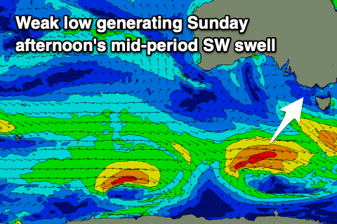
- Small increase in mid-period SW swell Sun PM with N/NE winds, tending E/SE later PM
- Easing surf Mon with N winds, shifting S/SW late PM
Recap
Monday's pumping day of waves wasn't quite followed up through yesterday, with a drop in size and lumpier conditions on the Surf Coast, average to the east. Conditions deteriorated mid-late morning as winds shifted onshore to the west, but today we've got a new pulse of SW groundswell and clean conditions with waves to 4-6ft on the Surf Coast. Our new SW groundswell should peak through the day with more consistent sets in that upper 6ft range on the Surf Coast magnets.
Locations to the east are better with the lighter onshore wind and we'll see a S/SW breeze arriving late morning, freshening into the afternoon so surf before then.
This week and next (Dec 1 - 9)
Moving into the end of the week, we've got one final pulse of SW groundswell and it'll come in large across both regions though with unfavourable winds thanks to a trough moving through this afternoon and evening.

Today's SW groundswell will start to ease overnight with a temporary drop into tomorrow morning ahead of the new S/SW groundswell into the afternoon/evening.
This swell is being produced by a strong low that's formed on the backside of the frontal progression linked to our current run of quality surf, with wind speeds reaching severe-gale-force, with a few bursts of storm-force winds at the lows core.
It looks like tomorrow will see the size drop back to the 4ft range on the Surf Coast, 5-6ft to the east ahead of the new groundswell which should build to 6ft+ into the late afternoon on the Surf Coast and 8ft to the east.
Conditions will be average with a moderate S/SW breeze at dawn, shifting S/SE and freshening through the morning, back to the S'th through the afternoon.
Winds will try and improve into Friday and ease while swinging E/SE east of Melbourne but remain SE on the Surf Coast along with still large, easing sets from 4-5ft+ on the Surf Coast and 6ft+ to the east.
As touched on in Monday's notes, the weekend looks much better for a surf, but a trough will bring varying winds on Saturday morning, N-N/NE to the east of Melbourne and N/NW on the Surf Coast. Afternoon SE sea breezes will develop early afternoon, shifting more S into the afternoon.
Size wise, the swell will ease off fairly rapidly so surf in the morning to get the most out of the action with dropping 2-3ft sets on the Surf Coast magnets and 4ft sets to the east.
Sunday is now looking a little better with an expected through and change forecast on Monday due to be weaker. This will see morning N/NE winds, holding into the early/mid afternoon ahead of late sea breezes.
A small pulse of mid-period SW swell is due into the afternoon on Sunday, generated by a weak low traversing our swell window later in the week. A fetch of W/SW winds to the south-west of Tasmania into Friday evening and early Saturday looks to produce a fun kick back to 3-4ft on the Mornington Peninsula and 2ft on the Surf Coast into the afternoon. That window with the new swell and before the sea breeze kicks in will be the pick.
Easing surf is due into Monday with a N'ly offshore ahead of the trough finally moving through into the afternoon, bringing a S/SW change.
Looking at the rest of next week and the models diverge regarding a deepening, broad mid-latitude low pushing in from the west, but regardless there's no decent swell due until later in the week but with what looks to be S'ly winds as we fall under the backside of the low. We'll have to have another look at this on Friday.