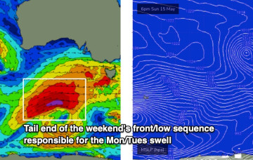
Small and clean this weekend with a series of S pulses next week
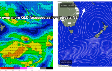
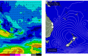
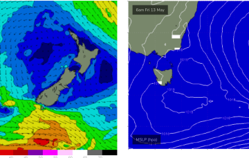
Further south the NE swell is now on the wane, with some surfable leftovers on offer over the weekend.
Pumping surf across the region since the last f/cast with more to come over the weekend.
The fetch of deep E to E/NE winds in the Coral and Northern Tasman Sea is contracting northwards around a surface low off the CQ/Fraser coast, and expected to fizzle out over the weekend. At present gales are retrograding towards the QLD, generating large swells.
No great change to the weekend f/cast. The fetch of deep E to E/NE winds in the Coral and Northern Tasman Sea is contracting northwards around a surface low off the CQ/Fraser coast, and expected to fizzle out over the weekend.
A deep polar low is tracking NE from E of Heard Island today, with a long trailing fetch of SW gales and seas in excess of 20ft in a wide swathe. Iterations of this storm system will bring strong pulses of SW swell over the next few days and into the weekend, with onshore winds a problem.
The models have slowed Friday’s frontal passage, which has delayed the weekends inbound westerly swell.
NE swell from the bottom end of the fetch is now looking a bit weaker and less persistent for East Coast Tasmania.
A trough forms a surface low later today off the NQLD coast, drifting south through Thurs and Friday before fading out and tracking back NE towards New Caledonia.
The outlook for early next week has improved a lot, thanks to a subtle shift in the timing of the main frontal passage.
A long interior trough and developing trough/low off the North QLD coast are tightening the pressure gradient along most of the ridge, bringing fresh onshore winds and a deep E’ly pattern to the majority of Tasman Sea and Central/Southern Coral Sea.