Rare SE groundswell in the mix

Victorian Surf Forecast by Craig Brokensha (issued Friday 8th July)
Best Days: Sunday on the beaches, Monday morning selected breaks for the keen
Features of the Forecast (tl;dr)
- Easing S'ly windswell tomorrow with abating mod-fresh S/SW tending S/SE winds (possibly W'ly early Surf Coast)
- Inconsistent, small mid-period SW swell for tomorrow, better Sun with E/NE tending NE winds
- Fading SW swell Mon with strengthening N/NE winds
- Inconsistent, small and flukey SE groundswell for later Sun, peaking Mon AM then easing
- Inconsistent, small W groundswell building Tue with fresh W/NW tending stronger SW winds
- Mix of swells Wed with strong S/SW winds
- Easing weak swell Thu with NW tending SW winds
Recap
Clean conditions on the Surf Coast but small to tiny, leftover 1-2ft waves, fading further through the day as a change moved through. Conditions were poor to the east with strengthening onshore winds.
Today we've got a localised increase in windswell and generally poor conditions.
This weekend and next week (Jul 9 - 15)
Tomorrow looks to remain generally poor across the state as a trough that moved through yesterday has formed a weak low pressure cell, projecting strong S/SW tending S winds into us through today.
 This is generating the localised windswell and it should start easing from the 3ft range tomorrow morning on the Surf Coast, 4ft+ to the east.
Conditions will be average though with an abating moderate to fresh S/SW breeze, shifting S/SE into the afternoon. There's a chance for early lighter W winds on the Surf Coast but with the low quality of the swell it's not worth chasing.
Sunday is still the day for the beaches with a new, inconsistent mid-period SW swell and E/NE tending NE winds. This inconsistent swell was generated through this week, south-west of Western Australia and should provide 2ft to likely 3ft sets on the Surf Coast magnets and 3-5ft to the east in the morning, easing through the day.
With the inconsistency expect a wait for the bigger sets.
Monday morning will become smaller and if keen for a surf, get out early before strengthening N/NE winds get into the fading swell. The Surf Coast looks to ease from 1-2ft with 2-3ft sets to the east.
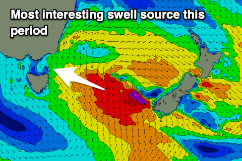
Now it's also worth noting that we'll probably see some sneaky SE groundswell sneaking through Bass Strait later Sunday and Monday, generated by great fetch of gales developing off New Zealand's South Island. Selected spots on the Surf Coast should see 2-3ft sets from this source, but with that tricky N/NE breeze.
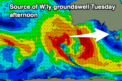 Moving into Tuesday and a strong but weakening frontal progression moving in from the west will cross us as a surface trough Monday evening, bringing a W/NW tending SW change through the day.
A small, acute W'ly groundswell will be in the water, generated by a fetch of W/SW gales just within our western swell window from the earlier stages of the frontal progression (south-west of Western Australia). A peak in size is due Tuesday afternoon but the Surf Coast which will be cleanest doesn't look to top 2-3ft.
Winds will remain strong from the S/SW on Wednesday as the swell eases, swinging back offshore from the NW Thursday morning ahead of another front. There'll be nothing significant swell wise though with easing 2ft sets on the Surf Coast.
Longer term the outlook remains very slow unfortunately. Weak, mid-period swells are due but with favourable winds for the beaches into the second half of July. More on this Monday. Have a great weekend!
Comments
Does the se swell come in between flinders island and the prom or around tassie?
Likely both, between Tassie and Flinders and Flinders and the Prom.
I did an overnight hike, with surf gear, into an area of the prom on one of these swells a few years back. After 30kms and torrential rain arrived at the area I was hoping was a wave to find complete pus.
Not another soul around, land or water, and despite no waves was still an epic trip.
At least you won't die wondering. Good on you for having a dig.
Bummer about the waves but love the ambition!
There are stories of some mythical beasts in these swells. Lots of big fish too.
With a SE swell would Red Bluff on
the Gippsland coast get some waves if the wind is cooperating?
Go have a look Tee
It'll be maxing. The swell on the exposed coasts will be very large.
https://www.gippslandports.vic.gov.au/boating/webcams/lakes-entrance-fla...
a few lefts firing along that coast the further east ya go