Very large surf ahead, plus favourable windows to boot

Victorian Surf Forecast by Ben Matson (issued Friday 13th May)
Features of the Forecast (tl;dr)
- Small windy weekend ahead, maybe some OK open beaches early Sat
- Very windy Mon with rapidly building swells
- Very large Tues with winds veering W/NW, ideal for super protected/novelty spots
- Large and easing Wed but winds going back W/SW (early W/NW in TQ)
- S'lies for Thurs
- Small swell and E'lies next Fri - Mon, ideal for open beaches
Recap
Steady 4ft surf west of Melbourne on Thursday still pushed the 6ft mark east of Melbourne, before easing slightly to 3ft+ and 4-6ft respectively this morning ahead of a further slow decline in size through the day. Conditions have been clean with light winds.
This weekend (May 14 - 15)
No real changes to the weekend outlook, with freshening N’ly winds tending NW through Saturday and then becoming fresh and gusty into Sunday.
Today’s swell will continue to bottom out into Saturday. If we’re super lucky, the Surf Coast swell magnets may pick up stray 2-3ft sets early, but by and large we’re looking at slow 1-2ft waves for the most part, even smaller into the afternoon.
East of Melbourne will be a little bigger (3-4ft easing to 2-3ft) but there’ll only be a brief window of opportunity at exposed beaches before it becomes blown out. Don't get your hopes up.
Sunday has a minor swell increase on the cards, but gusty NW winds will confine the best conditions to the Surf Coast and there won’t really be enough size or consistency to worry about - maybe some occasional 2ft sets if we’re lucky. East or Melbourne will be generally a write off under these conditions.
Next week (May 16 onwards)
The models have swung back and forth regarding the upcoming storm track (relative to its proximity to the Vic coast), and therefore the impact it’ll have on local surf conditions. However we’re now much closer to the event so confidence is becoming stronger on what we’ll see.
And that is…. A lot of wind. And a LOT of swell.
Monday will kick off with moderate swells and strong to gale force NW tending W/NW winds, even W’ly through the day, as a series of significant fronts cross through Bass Strait.
The parent low to these fronts is a complex beast, already beginning to undergo cyclonegensis in a few regions, as a polar low (off Antarctica, south of WA) and a cut-off low in the western Bight.
These lows will coalesce to form a large primary system by Sunday - generating a mix of mid-range swells from the W/SW quadrant, and surf size will build correspondingly through Monday - let’s peg the morning around 3-4ft in Torquay with the afternoon likely to push 6ft+ (bigger east of Melbourne, of course). But with the westerly gales, only protected spots will be worthwhile.
Tuesday will see a peak in size, originating from a powerful front wrapping around the northern flank of the primary low, late Sunday into Monday (see below). Direction will slowly turn from the W/SW to the SW through the day, suggesting a peak into the afternoon.
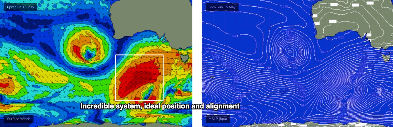
I really don’t want to over-egg the omelette, but the associated fetch is lining up in the best part of the Vicco swell window (relative to surf size and consistency), and will remain slow moving as it reaches maturity, drawn out over an impressive 30-odd hours or so, which helps to exaggerate eventual surf size above the usual model expectations. It's not a common event.
What this means is that we’re looking at a very large, powerful surf in all areas on Tuesday. How big? In Wednesday’s forecast I mentioned a general size range of 6-8ft+ surf along the Surf Coast, with a chance for 8-10ft+ sets at the swell magnets - and if anything I feel a little more confident in this outlook (could it push higher? Wouldn't rule it out).
Of course, not all locations will see the upper end of this size range, but regionally speaking, the model guidance suggests Tuesday's swell event could push up into the top 5-10% of Victorian swell events we might see in a year, based on size.
As for conditions, the timing of the swell peak will be as a third front stands up just to our south-west, which should tweak the synoptic westerly flow to the W/NW. There’s even a chance some parts of the Surf Coast will pick up a NW airstream at times.
East of Melbourne will be even bigger at the open beaches on Tuesday, so it’ll be sheltered bays and points for surfable options, and the odd novelty spot.
There'll be a heck of a lot of water moving around at every coast, so choose a location according to your ability.
Wave heights will then gradually ease through Wednesday - initially still quite large, though perhaps a foot or two down from Tuesday’s peak. However we’ll be on the backside of the frontal progression by this time so the synoptic flow will tend SW of W across most regions. The Surf Coast often sees early W/NW outflows under these circumstances and so early morning should be the focus again.
Looking further ahead, and the western flank of the LWT associated with this pattern will clip Victoria into Thursday, pushing winds to the southern quadrant ahead of an easterly flow from Friday thru’ Monday as a high pressure system sets up south of the state and a surface trough develops over Western Australia.
We’ll see easing size from Friday onwards, in fact we’re now looking at a spell of small waves (even some E’ly windswell) thanks to a blocking pattern upstream diverting Southern Ocean fronts away from our swell window.
So, make the most of this active period as it’ll be back to the open beaches by next weekend, maybe for a few days too.
Have a great weekend, see you Monday!
Comments
Doesn't look too windy for Tues/Wed? BOM saying 15-20km.
15-20km/hr = 8-10kts.
But yeah, expecting plenty of wind. 20kts or so, occ higher gusts.
Thanks for the write up Ben, always a good read - at the peak of Tuesday's swell, are we still looking at a W/SW swell direction?
Ahh, missed that, soz. Slow turn from W/SW to SW (have added it in to the notes).
Thanks Ben - Looking forward to Monday's update.
Awesome.
By not over egging the omelette, I hope you haven't over egged the omelette...LOL.
Cheers for the update Ben. Great work.
What sort of swell period are we looking at for Tuesday Ben?
Probably 16-17 seconds.
A bit of pre indo training.. love it !
My car is now working and some very protected spots well inside in W.P, that seldom get waves, could be working. I am game for it !.
I have put a tracking device on your car and will be following you all over the wp like a ninja
It's all happened at just the right time Mr T. Good stuff & new transfer case will smile on you in snow & along 4x4 surf tracks :)
Good to hear you’re mobile again and going to score from all reports :) Nothing worse than been grounded whether it be injury, transport, other commitments when a solid swell is running and the winds are in reasonable cooperation
I have most recently been a centre bearing away from my nook or cranny.
Go charging tomorrow cobber.
At this rate Ben you might get swapped in permanently!
Damn finally another one of those swells where I want to be in about 15 locations at once. Fark you teleportation technology, plenty of time between drinks and still nothing *slams fist on table
Great week to be stuck in the worst capital city in Australia…Darwin. FFS
Ah well you can um, er, ah, um...
I did enjoy looking up at the sky when in Dawin.
Haha. No 1 activity on TripAdvisor!!
Had I stayed longer it might have descended into vice
Cannonball running to Katherine was fun though, the bottom suspension of the VZ hiremobile tended to bottom out on the bumps/corners at 155 so I backed off a little
Hmmmmm wonder if the PNB will be up & running again by next week. It will be interesting to see the numbers.. Does anyone know / have any updates with what’s going on with it?
Cheers as always too Benny :)
Not sure, will see if we can find out.
Its funny. Its offline and it becomes a concern. But if it’s online, I don’t really use it.
Not the slightest concern Bone but just interested on some numbers & reference some embedded pulses. Its all a learning experience
Sorry. Context was it became a concern for me all of sudden whilst it’s been done. I like data
The next swells going to give the buoy mooring a shake up, might be just what is needed.
im not certain but i think these are university trial ones
https://vicwaves.com.au/
Oh nice, thanks for that.
Thanks a lot PD, now I have 7 buoy windows open in anticipation haha
My camp site is booked and I will be surfing two days in a row with these off shore winds and large swell in operation. I do remember one year in Autumn or winter at W.P. when the surf was so big it just dumped me each time and put me into the washing machine of doom !.
:-0
Be careful MrTee
I pity the fool;)
Ben, I'm guessing Craig is on leave, hence the delayed reports the last week or so?
Yep. Will be up soon. Keen for an update, eh?
There are only so many times I can hit refresh.
Ya killin us Ben
Here ya go..."Huge and clean"
Yeah pretty keen. Building today, lully with the hint of size. Yesterday small 2ftish for us, with wind but you could see the new swell in the water even then.
After Friday's 5-10% type comments and omlette cookings.... yes I am keen.
Cmon guy
You might think somebody went surfing and forgot to push the "send" button !
just kidding. maximum respect to the forecasters team.
That's how the old fm surf report would work way back when on the good days
I for one liked the suspense! Besides its on the way as confirmed with my own eyes ;)
I like the words captured fetch and beyond theoretical estimates. Thanks as usual Benny, great write up/s