Great run of autumn surf developing

Victorian Surf Forecast by Craig Brokensha (issued Wednesday 13th April)
Best Days: This afternoon, tomorrow, Friday, Saturday morning, Sunday
Features of the Forecast (tl;dr)
- Mod-large S/SW groundswell building Wed PM with light S/SE winds
- Easing S/SW groundswell Thu with a reinforcing SW groundswell for the late PM
- Light-mod N/NW morning winds Surf Coast Thu AM, N/NE east of Melbourne ahead of weak sea breezes
- Easing SW groundswell Fri with N/NW winds, ahead of a shallow mid-late PM S/SW change
- Moderate sized + SW groundswell building Sat PM with light local offshore winds and mod-fresh E/SE sea breezes
- Easing SW groundswell Sun with gusty N winds (N/NE east of Melbourne)
- Building, inconsistent SW groundswell Mon PM with freshening SW winds
- Easing swell Tue with S/SE winds
- Large SW groundswell likely later next week
Recap
Monday's pulse of moderate sized S/SW groundswell eased slowly through yesterday in both size and period with lingering onshore winds. Conditions were bumpy but surfable across both coasts and to 3ft on the Surf Coast, 4-5ft to the east.
Today we've got a temporary low point in swell with light, workable onshore winds ahead of our strong, moderate-large S/SW groundswell this afternoon. Cape Sorell is rising nicely and we should see sets hitting 4-5ft on the Surf Coast (possibly rare bigger clean up on the magnets later) with 6ft to possibly 8ft sets to the east. Winds will only be light from the S/SE creating decent conditions with the strength of the swell.
This week and next (Apr 14 – 22)
This afternoon's strong pulse of S/SW groundswell should peak this evening and start to ease through tomorrow under a light N'ly offshore breeze. Winds will tend N/NW on the Surf Coast and N-N/NE east of Melbourne with sea breeze being weak and light.
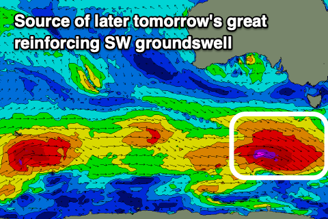 Our reinforcing pulse of SW groundswell for the afternoon looks to arrive later rather than earlier now, with it generated by a great fetch of severe-gale W/NW winds pushing through our swell window today.
While not ideally aligned, the breadth and strength of the fetch as well as acting on the back of the active sea state generated by the strong polar low generating today's swell, will help boost wave heights later in the day and Friday morning, with an easing trend through the day.
Size wise, tomorrow morning should be around 4ft on the Surf Coast with 6ft sets on the exposed beaches east of Melbourne. Expect the size to ease a touch through the day ahead of the reinforcing groundswell which should kick wave heights back to a similar size as the morning later in the day.
Friday morning should see easing sets from 4ft on the Surf Coast magnets, 5-6ft to the east and with light N/NW winds ahead of a shallow, mid-late afternoon S/SW change as a trough clips the state.
Moving into the weekend and another temporary low point in swell is due Saturday morning though not below 3ft on the sets across the Surf Coast, 4ft+ to the east ahead of a new, SW groundswell into the afternoon.
 The polar low linked to this swell has been upgraded slightly in strength and we're due to see a small but sustained fetch of W/SW gales generated through our south-western swell window from today through Friday morning.
This swell will have a bit of south in the direction, falling between SW and true S/SW and kick wave heights back to 4-5ft on the Surf Coast later afternoon and 6ft to possibly 8ft to the east.
Due to the weak nature of Friday afternoon's change, winds look variable and locally offshore Saturday morning ahead of moderate to fresh E/SE sea breezes. Sunday will see stronger N'ly winds kick in (N/NE east of Melbourne) ahead of an approaching trough as Saturday afternoon's swell starts to ease. Sets to 4ft are still due on the Surf Coast, 6ft to the east and easing through the day.
 Moving into next week and the trough pushing through early morning looks to bring a SW change just after dawn Monday with a further drop in swell from the weekend.
Our next swell is due to be inconsistent and arriving into the afternoon, generated by a more distant polar low. Size wise it looks to be 3-4ft on the Surf Coast and 5-6ft to the east, easing Tuesday with lingering S winds, but we'll confirm this Friday.
Longer term we're looking at one of the largest swell producers we've seen all year firing up south-west of Western Australia on the weekend. This looks to produce a large SW groundswell for later next week though with S/SE winds. More on this and the local conditions Friday.
Comments
All hail King Craigos!
That must be the best outlook in 20+ weeks. Great to see the ocean finally awaken from its slumber.
Is that headline some kind of sick joke Craigos don’t be messing with us like that
I have a theory on why those highs didn't push the low away and allowed the swells to move up into the Vicco swell window. Saw this potential swell a while out and took a punt that it would come through.
High's still there, it's just that the polar systems fired up.
Watching those highs in real time one stayed up higher and they also split in half as opposed to the predicted one big high over the southern half of the country. Looks like that's allowed the low to redirect from straight West/East to have a little slip stream pointing straight at vicco. Definitely a different looking setup to what was forecast re. highs. I think! ha.
Agh but remember it's not actually forecasting highs, but higher than normal pressure compared to normal.
Ie this time of year we'd be getting cold fronts pushing through but instead we've got weaker troughs and highs but with that increased polar frontal activity.
Check that. Adding it to the nemory vault. Cheers Craig
Looks and feels like autumn out there!
Great News! I found the seasonal switch mechanism on Sunday, I selflessly gave it a good, forceful adjustment and you could instantly feel the difference.
I hope you'all have a great Easter and Anzac long weekend full of epic waves, its been a testing wait for us Southern frothers but finally our beloved Southern Ocean is back in the game. I'll see you out there in 6 weeks or so. Yeeew!
Thank you Walk around G. May the surf god's treat you kindly when you're ready to get back out there!
I must say, some serious activity in my pants reading this forey...
Aghh bugger. MTB? All the best with the recovery.
Heal up well WaG!
Nah it's my crook back that just started playing up a couple of days ago out of nowhere for the first time in about 3 years.
Hope you get back in the brine soon, WAG. I'll have one for you if my knee holds together.
The size is filling in. Not epic huge, but it's begun
Thanks fella's, should be all good. MX with my son and nephew, hadn't even warm-up fully and made a mistake blasting through a berm and that was the result. Funny how fragile bones can be on the wrong angle. It was interesting to see how the boys reacted in a crisis, they didn't panic, loaded the bikes back on the trailer so I could drive back to Hospital in Geelong, was a real proud Dad moment watching them sort it all out.
I'm now officially their photographer and pitboard team member for a while.
Books in trip to Queensy / NNSW due to the no surf fatigue and seeing endless waves roll down endless sandbanks…