Autumn swell spoilt but summer winds

Victorian Surf Forecast by Craig Brokensha (issued Monday 28th March)
Best Days: Tomorrow morning exposed beaches
Features of the Forecast (tl;dr)
- Small surf tomorrow with light, variable S winds in the AM
- Strengthening S/SW winds Wed, strong S/SE Thu
- Mod-large SW groundswell Thu, easing Fri with strong SE tending S/SE winds
- Easing surf on the weekend with gusty SE-S/SE wind Sat, moderate S/SE Sun
Recap
Not the best conditions for the Surf Coast on Saturday though improving through the day with light E/SE winds and some new, building S/SW swell which kicked to 3-4ft through the day. The exposed beaches to the east were cleaner but solid.
Yesterday was the pick across the Surf Coast with a reinforcing SW groundswell filling in under light winds. The surf was 3-4ft on the magnets with locations to the east coming in at 5-6ft.
Today the swell has dropped back on the Surf Coast to a slower 2ft to occasionally 3ft but with great conditions, good east of Melbourne with clean 3-5ft waves. Make the most of conditions as a strengthening S/SW breeze is due into the afternoon.
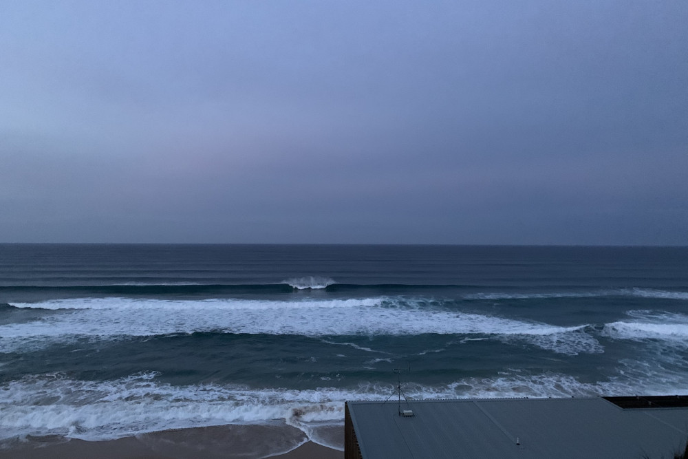
Tasty on the peninsula this morning
This week and weekend (Mar 29 – Apr 3)
After the recent run of light winds, clean conditions and fun surf we've got a bit of a poor period ahead this week.
The trough responsible for this afternoon's change is now weaker than expected on Friday and as a result we're looking at variable winds tomorrow morning out of the S'th with no lift in new swell. The Surf Coast looks to be back to 1-2ft with 2-3ft sets to the east. While not ideal the exposed beaches to the east should have clean, possibly slightly lumpy waves.
Moving into Wednesday, a cold front spawning off the strong polar low mentioned in Friday's notes will clip the state, bringing strengthening S/SW winds through the afternoon and with no new swell due until later in the day but more so Thursday.
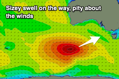 This swell looks to be moderate to large in size, generated by the polar low proper yesterday, today and through tomorrow.
An initial, distant fetch of severe-gale W/SW winds were generated south-east of the Heard Island region, with the low now weaker and producing a fetch of strong to gale-force W/SW winds as it continues east.
The size looks to be a touch less than expected on Friday but winds will spoil in in any case with strong S/SE winds due as a strong high moves in behind Wednesday's change.
Size wise the Surf Coast should see 4-5ft surf, with the possibility of the odd bigger cleanup on the magnets, 6ft to occasionally 8ft to the east but with those poor winds.
We'll see the high continuing to move east into Friday but a deep and powerful low forming off the East Coast will slow this progression down slightly.
This will result in strong SE winds Friday morning, shifting S/SE through the day as the swell eases from 3ft to occasionally 4ft on the Surf Coast and 4-6ft to the east.
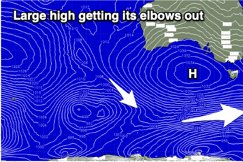 Unfortunately with the low off the East Coast winds will hold from the S/SE-SE on Saturday (fresh and gusty) with moderate S/SE winds on Sunday.
All this SE wind will kick up some poor SE windswell across the Surf Coast, not a good combo with the easing SW swell.
Whether or not winds fully improve into early next week is yet to be seen but by then the swell will be all but gone.
Longer term the large blocking high looks to block any major activity for the rest of the week at least. More on this Wednesday.
Comments
Extended forey looks terrible for the Bells comp (waiting period starts 10 April)
Nope. Will have an early FC tomorrow.
‘Nope’ as in yes you’re right, it’s gonna be average, or ‘nope’ as in its actually looking pretty good and the current models are off…
Or I can wait until you’re forey tomorrow
Yes
Ha yeah, poop.
Honestly it's just been nice for a little while, great surface conditions and a bit of swell. Hope everyone got some and is stoked. Was very fun to get out of 2nd gear into 3rd gear and arc a few turns.
Fun size down your way yesterday and yeah nice on top. Busy though which made it a bit frustrating with the wait between sets.
Go for a drive Bnkref
Hasn’t it been fun. Glassy like Indo conditions and some moderate swells can’t be beat. Winds have remained more than friendly for extended periods of time. Have lucked into endless fun waves over the past 3-4 weeks
The only positive about the atrocious week or more forecast for the SC leading up to the comp is that it improves the chances of some good days during the comp. That's my theory anyway. We live in hope.
The North side of The Island could be busy on Friday.