Get stuck into the beaches

Victorian Surf Forecast by Craig Brokensha (issued Wednesday 2nd March)
Best Days: Thursday and Friday morning on the beaches
Features of the Forecast (tl;dr)
- Inconsistent SW groundswell tomorrow with mod-fresh E/NE winds ahead of mid-late afternoon E/SE-SE sea breezes
- Easing SW swell Fri with light-mod NE tending S/SE winds
- Strengthening S/SW winds Sat (possibly light in the AM), strong S tending SE on Sun with a mix of localised windswell and inconsistent SW groundswell
- Reinforcing mid-period SW swell Mon easing Tue with gusty SE winds Mon, strong S Tue
- Moderate sized SW groundswell Wed and Thu with gusty E/SE winds Wed and morning E/NE winds Thu
Recap
Good surf across all locations yesterday with a building south-west swell, mixed in with some south-east windswell energy, building to an easy 3ft on the Surf Coast with variable winds and 4-5ft to the east.
The swell has backed off a touch this morning but was still coming in at 3ft on the Surf Coast magnets, with 4ft sets to the east under a fresher E/NE breeze.

MP magic the morning
This week and next week (Mar 3 - 11)
The exposed beaches will continue to offer clean, fun surf into the end of the week with deteriorating conditions from the weekend as a deepening surface trough slides in from the west.
Looking at the coming days though, the swell will become less consistent tomorrow but should hold around 2ft to occasionally 3ft across the Surf Coast magnets and 4ft on the sets to the east. The source of this inconsistent swell was a strong but distant low at the end of the progression linked to yesterday's and today's waves.
Winds will be great for locations east of Melbourne with a moderate to fresh E/NE breeze ahead of late E/SE-SE sea breezes. A light to moderate NE offshore is due Friday morning ahead of afternoon sea breezes with easing, inconsistent sets from 2ft on the Surf Coast and 3ft to possibly 4ft on the Mornington Peninsula.
There might be window of variable winds early Saturday before the trough shifts in from the west but swell wise it'll be at a low point.
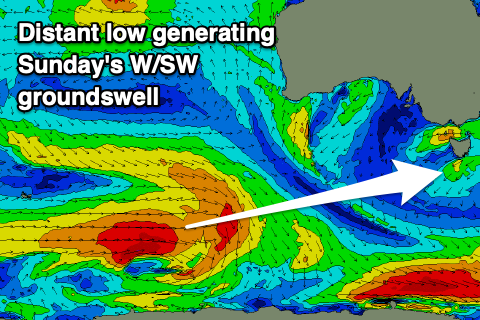
This trough will unfortunately spoil a fun SW groundswell that's due Sunday with strong S tending SE winds developing through Bass Strait as a low forms within it off the far southern NSW coast.
 The strong S'ly winds will extend off Tasmania's West Coast kicking up a local, stormy windswell likely to 3-4ft on the Surf Coast and 4-5ft to the east.
Coming back to the SW groundswell and this is being generated today by a strong low that's currently pushing east of the Heard Island region. A fetch of strong to gale-force W/SW winds are being produced, with it due to slowly weaken and stall south-west of Western Australia tomorrow before sliding slowly east on the weekend.
This will generate an initial SW groundswell pulse for Sunday with persistent levels of smaller, mid-period surf through Monday, easing Tuesday. Size wise Sunday's swell looks to be around 3ft on the Surf Coast and 4-5ft to the east, back to 2-3ft and 3-5ft on Monday.
 Gusty SE winds will continue to create poor surf on Monday with a shift back to strong S'ly winds due on Tuesday as another trough slides in from the west follow by a high.
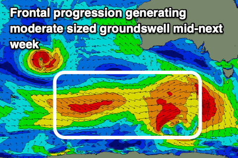
Again this will spoil a moderate sized SW groundswell event Wednesday/Thursday, generated by a healthy frontal progression moving under the country on the weekend. Size wise 3-5ft surf is due on the Surf Coast and 6ft+ waves to the east but with strong E/SE winds on Wednesday, possibly shifting E/NE as the swell starts to ease on Thursday. We'll confirm this next update.
Comments
Craig. Please inform Huey your overlord, that Easter is only 6 or so weeks away and he/she needs to get his/her act together real quick, or the Easter classic will again be moved to Newcastle. Thanks
Bugger the Bells Pro, give the long suffering Vics some quality conditions after the persistent run of absolute shite on the SC. Waking up every day to see more E and SE on the longe range forecast is fucked. At this stage March is looking a write-off for anything other than junky on/cross-shore mixed swells.
Totally agree Dx3, even some SW winds would be a help. At least there are a few places along the coast that are clean then.
Yep I'd take a SW right now with some swell for sure. Imagine if it flipped completely and we had persistent day after day of NW, or at the least W, just like we've had SE or E every day for weeks... one can only dream. Seriously fuck off La Nina
60 thousand dirty humans coming to crowd out the surf in Torquay over Easter ewww no thanks, that's too close to the next flu season.
Has to be the worst summer on record for sc doesn’t it? First half of march looking shiet aswell.
Worst for Vic in general
Do you have increased chance of getting hit by lightning in the ocean?
https://www.swellnet.com/news/swellnet-dispatch/2015/11/30/ride-lightnin...
"While sitting on their boards, surfers become the highest point of the surrounding area which makes them vulnerable. Lightning usually seeks the highest surrounding point, therefore if it were to strike somewhere in the vicinity it would hit them first. The same principle applies to tall trees, which don't physically attract lightning either, but their height makes them a target."
So if the local dunes are higher, or the trees might be a better chance.. :/
How gnarly is that footage!!!!!
And thanks, very informative. Probably could of stayed out haha.
2 in a row for exotic glass off instead of forecasted strong winds..
Yeah, sure Nick..... we've had light winds down the coast the last 2 days BUT it's still been absolutely shit. There's no sugar-coating it, it's been shit for month's. There's no point calling out or suggesting anyone is getting better waves than anybody else.....Nobody's had any DECENT waves in Vicco since.....well I forget.
You can't polish a turd, it'll still be a turd.
Not exactly true WAG...
Yeah its been shit for months, but there are degrees of shitness you see...
And I'm pretty confident due to the lack of swell and plenty of winds from the eastern quadrant then you surf coasters are wallowing in degrees of shitness far greater than us east coasters.
Hey i may be wrong!
Nah, nailed it Goof.
Upgraded surfcams at Woolamai:
Cam looks great Ben, good quality. As soon as I opened it, a 7 wave set hit the bank on the right, looks super fun out there today, bank on the left looking ok too.
Certainly will make it easier to know when to go visit indodreaming
Aha proof to show that this absolutely shit run has actually been pretty good. And I bet that's not even the good stretch of beach to be surfing in that area
Seeing these screen shots of Woolami reminds me of why I love getting over to PI. Compare this to what was on offer on the SC today. Wish I could get there more often.(I know the situation is reversed when it is a westerly pattern). It is nice to see some people getting good waves though.
Spent quite a bit of time "working" and watching these new cams. Plans to upgrade the others?
P.I locals will be over the moon.............
You'd almost think one would've been enough really.
hey C.B. i could proberly match with the bells finals on you tube for a basic guide but you might have a quick archive to check. was just wanting to pair up la nina summers with autumn seasons that followed for quality swells that came through following them down here in mexico. just interest for the long range prediction based on averages.
la nina summer. see below.
(appoligies any that are incorrect)
#1998
#1999
#2000
#2001
#2007
#2008
#2009
#2010
#2011
#2012
#2016
#2017
#2021
on a quick check
bells finals
1998 5ft
1999 ?
2001 ?
2007 2/3ft
2008 4/5 ft
2009 pumping 4/6 ft
2010 3/4 ft
2011 big 6/8 ft
2012 3ft
2016 big and chunky 6/8 ft
2017 6ft
2000?
2007 3ft
2012 3/4 ft
2021 nill pay
could be in for a drought breacker possibly...