Mixed swells and conditions but there are a few windows

Victorian Surf Forecast by Craig Brokensha (issued Monday 4th October)
Best Days: Wednesday, Friday
Features of the Forecast (tl;dr)
- Building mid-period W/SW swell and localised windswell tomorrow with strong W/NW tending W/SW winds
- Easing swells Wed with N/NW tending N/NE winds
- Building W/SW windswell Thu with strong W/SW tending SW winds
- Fun, mid-period W/SW swell Fri, easing through the day with fresh N/NW winds, easing later
- Easing swell Sat with fresh NW tending SW winds
- Building SW swell Sun with strong SW winds, peaking Mon with SE winds
Recap
Poor conditions Saturday with onshore winds out of the SW across most locations, though lighter and more workable across Phillip Island with a drop in swell from the end of last week.
Yesterday was cleaner and better across the beaches but back to the 2ft+ range on the Surf Coast, with infrequent 3ft sets on the Mornington Peninsula owing to the southerly swell direction.
This morning the swell is at a low point, clean on the Surf Coast but tiny.
This week and weekend (Oct 5 - 10)
Looking at tomorrow, and while the models show a decent kick in size, I'm still wary of the swell generating fetch linked to the mid-period W'ly swell.
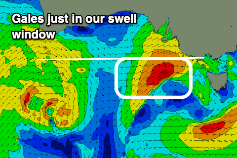 As touched on late last week, a strong mid-latitude front that's currently pushing through the Bight is too far north to generate any surf through our swell window, but it's expected to drift slightly further south on approach to us this afternoon while strengthening.
A fetch of W/SW gales will just be generated in our swell window before pushing through Bass Strait tomorrow.
What we'll see is a mix of local windswell and mid-period W/SW swell energy, likely coming in at 3ft+ on the Surf Coast and 5-6ft to the east, peaking late morning and a little undersized early.
Conditions will be windy and raw, cleanest in protected spots with a strong W/NW breeze, shifting W/SW into the afternoon.
Owing to the close-range nature of the swell, we'll see it dropping rapidly into Wednesday but conditions will improve for the beaches with a morning N/NW breeze due to shift N/NE from late morning, so aim for the beaches from midday onwards.
The Surf Coast looks to drop back to 2ft, with 3-4ft sets to the east.
Some background, mid-period energy might be seen into the afternoon but this looks to just steady the easing trend.
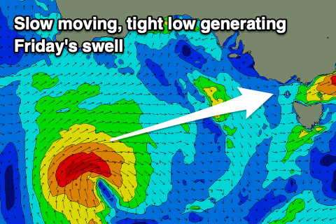 Looking at the secondary, better positioned frontal system and this now looks a bit slower moving and tighter in nature, resulting in a delay in the swell's arrival until Friday.
The swell generating system is currently south of WA, and we should see a tight low form this evening, generating a slim fetch of stalling W/SW-SW gales through our swell window tomorrow, projecting slowly east Wednesday while weakening, then across us Thursday.
As the front moves across us Thursday it'll kick up a weak W/SW windswell, likely reaching 3ft into the afternoon on the Surf Coast and 4-6ft to the east but with strong W/SW tending SW winds. The Surf Coast will likely see a period of early W'ly winds, but the swell will be much smaller and weaker early.
Friday will be the pick as the mid-period W/SW swell from the tight low peaks with 3ft to possibly 4ft sets on the Surf Coast and 6ft waves to the east under a fresh N/NW breeze.
A drop in size is due through the day, smaller Saturday with a NW offshore ahead of a SW change.
Longer term, a broader, slower moving low forming under the country late week looks to produce a prolonged, mid-period SW tending S/SW swell for Sunday/Monday, but a trough related to the low looks to bring SW winds Sunday, SE into Monday. We'll have a closer look at this on Wednesday though.