Fun waves on the magnets to end off the week

Victorian Surf Forecast by Craig Brokensha (issued Wednesday 30th June)
Best Days: Later tomorrow, Friday, Saturday, early Sunday for the keen on the Surf Coast
Features of the Forecast (tl;dr)
- Inconsistent, building mid-period W'ly swell later tomorrow with moderate to fresh N winds (tending N/NW on the Surf Coast in the PM, N/NE to the east)
- Peak in W/SW swell Fri AM with strong N winds, shifting NW late afternoon
- Slightly better W/SW swell for late Fri
- Fun W/SW swell Sat with strong N/NW tending NW winds, easing Sun with strong W/NW tending W/SW winds
- Small, mid-period S/SW swell for Tue/Wed
Recap
Great waves across the beaches yesterday with Monday's S/SW swell easing back fairly abrubtly overnight, leaving clean 3-4ft waves on the Mornington Peninsula, 2-3ft on the Surf Coast, smaller into the afternoon.
Today, the last day of the month we're left with near flat conditions on the coast, right in the middle of winter.
This week and next (Jul 1 - 9)
Moving into the end of the week and we've got fun surf on the way for the beaches again, more so tomorrow afternoon and into Friday morning, but windy.
The surf is likely to start small to tiny tomorrow morning (possibly 2ft on the Mornington Peninsula) but into the afternoon the first hints of W'ly swell from a strong frontal progression pushing up and into Western Australia should be seen.
 It'll only be mid-period energy but should increase slowly to 2ft to possibly 3ft by dark on the Surf Coast swell magnets and 3-5ft to the east.
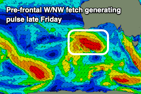
This swell will peak Friday morning to an inconsistent 2-3ft on the Surf Coast swell magnets, 4-5ft to the east, while a better, reinforcing pulse of W/SW swell should be seen into the late afternoon.
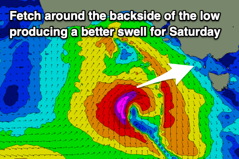
The source of this swell will be a short-lived fetch of W/NW gales under Western Australia today, swinging more NW while pushing under the Bight this evening and tomorrow. There's a better fetch of gale to severe-gale winds due on the backside of this pre-frontal fetch as a tight low forms, and this should provide a bit more size and swell Saturday.
 Coming back to Friday afternoon though and we should see the Surf Coast kick later in the day to a more convincing 3ft, with 4-6ft sets to the east.
Saturday is a little tricky but we'll likely see 3-4ft sets on the Surf Coast in the morning, 5-6ft to the east, easing into the afternoon and then smaller Sunday.
Coming back to the local winds and tomorrow will see all day, moderate to fresh N winds, likely tending N/NE east of Melbourne into the afternoon, lighter N/NW on the Surf Coast.
Friday will see stronger N winds as the developing low linked to Saturday's swell edges closer to us, though it'll stall west of us until moving through Sunday afternoon. Winds are due to swing NW into the late afternoon Friday, with Saturday seeing strong N/NW tending NW winds.
As the low pushes east Sunday, winds will swing from a strong, early W/NW'ly around to the W/SW but there doesn't look to be any swell arriving behind it (just some local, weak windswell).
Smaller fading surf with a morning W/NW wind is more than likely Monday.
Following the swell through the weekend there's nothing too significant on the cards as the stalling low to our west combined with a strong high across the Bight, and another mid-latitude low off Western Australia dominate our swell windows.
A strengthening polar front south-southwest of Tasmania on the weekend may generate a small S/SW swell for Tuesday/Wednesday under light winds from the northern quadrant. We'll have a closer look at this Friday though.
Comments
How good is summer!
Ha!
Can't tell the difference between the surf and st kilda cams now, unreal for this time of year. Been 1 of these days nearly every week this month when we don't really get them through the summer months
Yep it is like ground hog day down here. One sunny day after another with summer waves. Craig where did that burst on Monday arvo come from had a bit of push in it?
That was from this polar front..
The incoming tidal push probably helped it pulse a little on the peninsula as the morning was reported to be under-sized, but not on the Surf Coast.
Smaller fading surf.......not quite what I'd like to hear in winter.
I can put up with ice on the windscreen and negative wind chills if it's 4-6ft+ and pumping, but the gloss comes off fast when it's 2-3ft with easterly wonk in it.
A slow, slow upwards trend..