Options aplenty this period

Victorian Surf Forecast by Craig Brokensha (issued Friday 25th June)
Best Days: This morning, tomorrow and Sunday morning Surf Coast, Monday, Tuesday on the beaches, late Thursday, Friday Surf Coast
Features of the Forecast (tl;dr)
- Easing SW swell tomorrow with a reinforcing S/SW swell for the afternoon, a touch smaller Sun
- Fresh W/NW winds tomorrow, tending NW late and then moderate W/NW Sun AM, tending W/SW and then S
- Good, mid-period S/SW swell Mon with local offshore morning winds, tending NE into the PM, easing Tue with mod-fresh N/NE winds
- New mid-period W/SW for Thu PM, peaking Fri with fresh-strong NW tending W/NW winds
Recap
The surf remained small and surfable on the exposed beaches yesterday with clean, inconsistent 2ft sets, tiny and to 1-1.5ft or so on the Surf Coast.
Today our new, inconsistent SW groundswell has filled in nicely with 3ft+ waves on the Surf Coast, 4-6ft to the east along with favourable winds. The remnants of a mid-latitude low that sat west of us most of the week is now moving in, bringing all this cold weather and rain, and we'll see winds shift onshore a bit earlier than forecast on Wednesday. Winds are due to swing W/NW across all locations by mid-late morning and then SW into the early afternoon.
This weekend and next week (Jun 26 – Jul 2)
The weekend looks fun in protected spots with moderate amounts of swell and favourable winds until Sunday afternoon.
We're due to see today's SW groundswell easing back in size from the 3ft range on the Surf Coast, 4-5ft to the east, holding 2-3ft and 4ft+ respectively into the afternoon as a reinforcing mid-period swell fills in. This and another slightly smaller pulse for Sunday are being generated by persistent polar fetches pushing through our swell window.
Winds look to hold out of the W/NW all day tomorrow, fresh and even tending more NW on dark. Sunday morning will see moderate W/NW winds and a touch less size, shifting W/SW by early afternoon and then S into the afternoon.
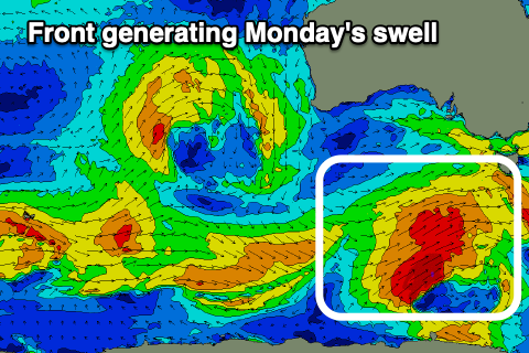 Moving into Monday and our better, mid-period S/SW swell is on track, as are the favourable winds.
This will be generated by a polar front that's currently south of WA, on the polar shelf, generating strong to gale-force W/NW-W winds. We'll see the front form into a low south-west of Tasmania tomorrow, generating stronger W/SW gales more in our southern swell window before passing east under that state Sunday.
The swell will be mostly mid-period energy but consistent and from a good direction, peaking Monday morning to the 4ft range on the sets across the Surf Coast, 6ft to the east.
Winds look great and locally offshore (N/NW Surf Coast and N/NE east of Melbourne), tending NE into the afternoon.
Tuesday will be nice and clean again with a moderate to fresh and persistent N/NE breeze as the swell eases from 2-3ft and 4ft respectively west and east of Melbourne.
The surf is due to bottom out again into the middle of the week along with stronger N/NE winds as a strong, though weakening mid-latitude front pushes in from the west.
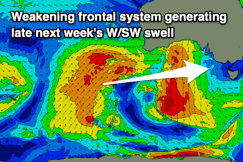 An initial great fetch of gale-force W/SW winds in our medium-long range swell window will weaken while pushing towards the Bight, generating a mid-period W/SW swell for later Thursday and Friday. A secondary front generating a slim fetch of severe-gale W/NW winds under WA should generate some additional swell, with building sets to 2-3ft late on the Surf Coast Thursday afternoon, 4-5ft to the east, and more to 3ft and 5-6ft respectively Friday.
Winds are likely to shift NW to W/NW on Thursday with the incoming front, similar Friday but remaining strong as we see the front slip south-east past us.
A stronger S/SW change is likely next weekend as another fronts pushes through though there's no significant swell associated with this.
The remnants of the front may turn into a Tasman Low, bringing onshore winds early into the following week along with a blocking high to our west, but we'll have a closer look at this Monday. In the meantime enjoy the current surf and have a great weekend!
Comments
I love you Craig
Fuckenhell..........
Do you still believe in Santa & the tooth fairy?
Monday morning looks good :-) .
It would want to be good because it's going.to be 2 degrees on Monday morning
Love you too Ringer!
Didn't expect this morning's pulse. There was the reinforcing pulse for yesterday PM but it looked nothing too amazing, with it due to ease today, but the buoys show the opposite with it peaking today. No complaints I'd say though.