A window to the east, then nothing until mid-late next week

Victorian Surf Forecast by Craig Brokensha (issued Wednesday 9th June)
Best Days: Friday morning on the beaches, Wednesday onwards next week on the beaches
Features of the Forecast (tl;dr)
- Large, stormy S/SE windswell tomorrow AM, easing into the PM with strong S/SE winds (abating rapidly near dark)
- Easing S/SE-SE windswell Fri with an inconsistent background SW swell. Light E/SE winds east of Melbourne in the AM, mod-fresh S into the PM
- Easing SW swell Sat with fresh W/SW winds (W/NW early on the Surf Coast)
- Near flat Sun with W/NW-W winds
- Inconsistent W/SW groundswell for Wed with E/NE-NE winds
Recap
Monday afternoon's better pulse of mid-period SW swell didn’t hang in as well as expected yesterday morning, with the Surf Coast easing back from an inconsistent 3ft with 3-5ft sets to the east under favourable offshore winds.
Winds shifted westerly into the afternoon and strengthened, favouring protected spots ahead of today's stronger S'ly change. Winds were lighter east of Melbourne early, but this window has now vanished. We've got a mix of S'ly windswell and new, W/SW groundswell but finding a quality wave will be hard.
This week and next (Jun 10 - 18)
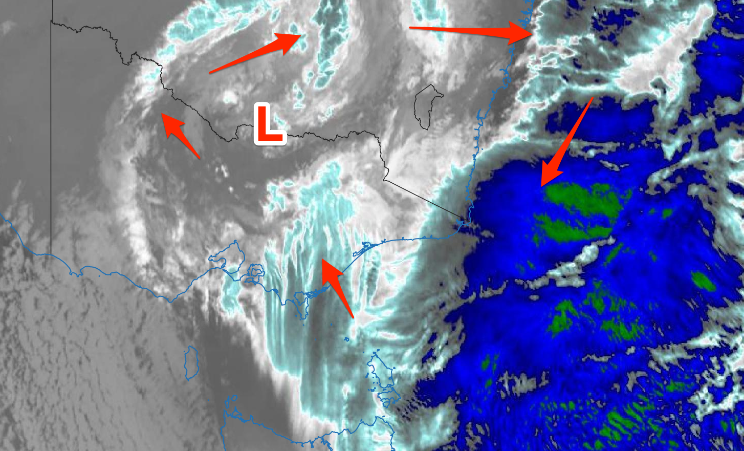
Cold, moist air spinning clockwise around the broad low (darker blue-green = very deep/high convection and cold air)
The deep cold pool linked to the change in weather and snowfall across our mountains is now set in.
We'll see it linger and dominate our weather through the end of the week and into the weekend.
During today the low will strengthen to our east, bringing strong to near gale-force S-S/SE winds through Bass Strait, whipping up a larger, stormy increase in swell through the day.
The low should weaken slowly tomorrow, resulting in winds still blowing strong through most of the day out of the S/SE, easing right back in strength into the evening, leaving lighter E/SE winds across the Mornington Peninsula and Phillip Island Friday morning (shifting moderate-fresh S from late morning).
Swell wise, the stormy energy out of the S/SE should start to ease through the day from a large 5-6ft+ on the Surf Coast tomorrow morning, 4-6ft to the east, fading rapidly into the evening as winds in Bass Strait abate.
Come Friday morning the S/SE-SE swell will be on the way out and some background, long-range SW swell energy should provide some OK options on the beaches. A peaky 3ft to possibly 4ft wave is due on the Mornington Peninsula Friday morning, though very inconsistent, with the SE windswell easing on the Surf Coast from a bumpy 2ft to possibly 3ft.
 As we move into the weekend we'll see the low starting to push east towards New Zealand, dragging up strong W/SW winds behind it on Saturday (likely W/NW early on the Surf Coast).
Size wise, there doesn't look to be much on offer at all with the long-range swell easing from 1ft to maybe 2ft wave on the Surf Coast, a bit bigger to the east but choppy.
There'll be no swell left into Sunday and a W/NW tending variable breeze will create clean conditions in protected spots.
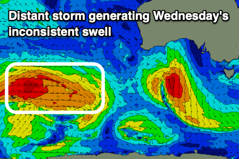
Unfortunately the start of next week is slow ahead of a new, inconsistent W/SW groundswell arriving late Tuesday, peaking through Wednesday. The source of this swell will be a very distant storm, firing up west of the Heard Island region tomorrow morning, then pushing east while generating a fetch of strong to gale-force W'ly tending W/SW winds. The storm will break down south-west of Western Australia resulting in a fair bit of swell decay and drop in inconsistency.
Size wise, the Surf Coast should see very inconsistent 2-3ft sets on the swell magnets, 3-4ft to the east with the odd 5ft bomb. One positive is with the storm being so distant from us, we should see E/NE-NE winds Wednesday morning, holding out of the E into the afternoon.
Beyond this a couple of similar swells are due into the end of the week and weekend with favourable winds, but we'll have a closer look at this on Friday.
Comments
Putrid. Hope the pools open for the city crew from Friday
So the low pressure system is going to circle around and create warm fronts on the back end of the weather event over the next two days. That's unusual and interesting for this time of year. Current temp 12 and rising that's extremely warm, although air temp more like 6
Yeah it'll be bringing warmer air in from the south-east, wrapping down from the Tasman Sea.
Craig, just wondering what the driver is for the warm/occluded front? Is it warmer air from further north or warmer air from the EAC? It's snowing at Perisher and raining at Buller.......
Ah great question, answered this on a FB weather group..
It's because warm air is wrapping in around the low from the north, east and then south-east. IE from the warmer Tasman Sea. Hence why the mountains have now warmed and NSW is now coldest.
Beauty, thanks.
Shame the eye of the storm is not100 -200km more to the east. Still looking consistent though.
insightfull stuff
Thanks Biggy.
Will the pier's bank at 3182 hold the big swell this arvo? I guess that surfcam will be earning its bikkies.
Looking pretty promising, few secret and no so secret bay spots will be handling it well.
The real challenge will be water quality, you'll be surfing in a mix of 30% bay salt water, 70% metro storm water.
Yep, don't fall off!
It's pumping at "Cranes" with no one out....where's that Dylan Graves guy? Perfect setup for him.
70% metro ecoli
There has been some memorable swell events over the Queen's Birthday Weekend over the journey. This doesn't look like it is going to be one of them which is comforting news for the Melbourne crew who will be still locked out of Regional Victoria.
Forecast is enough to make one bail and head to Caloundra...
And take a covid test....which seems to be the thing to do, if you're evading lockdown.
THIS!!! Haha I can't get my head around why a couple flees Victoria, up to Qld, apparently taking a discreet route to avoid detection if you believe the media articles, then wanders into a testing site to see if they have covid, surely knowing that if they test positive then contact tracers will be all over them. So odd.
Must be a couple of genuine deadshits to have done that and given themselves up in the worst possible way.
Given the family they were visiting live in a stockland slum, they are definitely deadshits.
Gary just put on a show at the heavily localised break at Albert Park pier was welcomed into the local surf gang.
Gary is now en route to get a 3206 tattoo on his neck and ‘My Brother’s BookKeeper’ on his chest.
Pier 3182 locals now smashing the windscreens of any Fords that look like they were purchased west of the big bridge.
Extreme moves required to preserve and protect these underground spots & their communities.
Wind this morning looked to have maximum fetch just west of the big bridge; any metro-kook-Covid-dogs get amongst it there?
Just like to say that this is NOT me
Pumping!!
Excellent bay footage! Well done Melbourne crew, top stuff. When life gives lemons, make Dylan Graves out of it.
It's a circus there these days. All over social media...crowds whenever it's on. It's like the goldie mentality has been shipped down to Melb metro. I blame the jetskis.
Still, surfed it at lunch today, swell was still solid, wind eased to cross shore 3ft from the SSE....15knots! Relatively warm air temp too. Had a few fun ones where I even managed to get a throwaway whitewash snap in!
Pool tomorrow, time for some real (fake) waves.