Options aplenty, followed by first proper swell of the year

Victorian Surf Forecast by Craig Brokensha (issued Monday 5th April)
Best Days: Selected locations east of Melbourne tomorrow morning and Wednesday morning, Thursday (beaches afternoon), Saturday morning surf Coast, Protected spots Sunday
Features of the Forecast (tl;dr)
- Slow easing trend in surf over the coming days with a light E'ly breeze east of Melbourne tomorrow AM, E/NE Wed AM, N/NW tending variable Thu
- SW change and building mid-period SW swell Fri, easing Sat with a W/NW morning breeze
- First proper swell of the year, that being a large, powerful, long-period SW groundswell for Sun with strong SW winds, easing Mon with S/SW tending S/SE winds
Recap
Small, clean waves across both coasts on Saturday with a slight kick in energy to 2ft on the Surf Coast and 3ft+ to the east, becoming less consistent and smaller on the outgoing tide. The Surf Coast was clean again Sunday morning but still small, bumpy to the east.
Our new, building swell was seen into this afternoon but the strongest energy has filled in today to 3-5ft on the Surf Coast and 6ft+ to the east with bumpy though workable conditions under a moderate southerly wind.
This week and weekend (Apr 6 - 11)
The frontal progression linked to the increase in swell yesterday which is peaking in size and energy today has since left our swell window, and as a result we'll see the swell easing in size over the coming days. It will be slowed by continued, less favourable polar frontal activity though, generating reinforcing energy through the coming days.
One such system is south-west of us, producing strong to gale-force W/NW winds late in our southern swell window.
So looking at the sizes and the Surf Coast should ease back slowly from 3-4ft on the swell magnets tomorrow morning, 5-6ft to the east, smaller Wednesday and down from 3ft on the sets across the swell magnets, 4ft+ to the east.
Winds tomorrow look more favourable for the beaches east of Melbourne with a light, variable E'ly breeze, lingering SE across the Surf Coast. Wednesday will be good on the beaches again with a light E/NE breeze ahead of afternoon S/SE sea breezes.
Into Thursday we'll see an approaching front bring N/NW winds possibly tending variable NE across the beaches to the ease into the afternoon with a small background swell. The Surf Coast looks to be 2ft or so, with 3-4ft sets to the east. Friday looks poor as a cold front brings a strong SW change. A mid-period SW swell will also build behind this front, reaching 3ft on the Surf Coast into the afternoon, 4-5ft to the east. Saturday should be clean with a W/NW offshore and surf easing from a similar size.
Looking at the outlook for the rest of the weekend and we've got a significant, 'bombing low' on the cards later this week, forming east of the Heard Island region. A 'bombing' low is one that drops 24hPa or more within 24 hours and this will drop about 34hPa from Wednesday afternoon to Thursday afternoon.
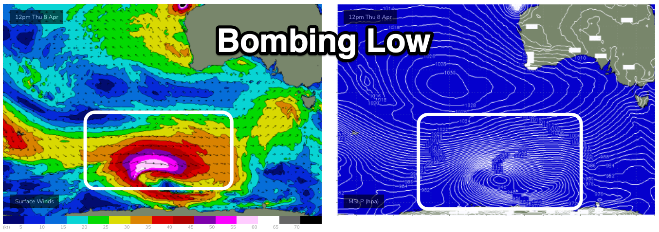
This will see a fetch of storm-hurricane force W'ly winds firing up along the polar shelf, projecting east and then north-east, up and across Tasmania on Saturday.
A large, long-period and consistent SW groundswell will be seen, filling in Sunday and peaking to an easy 6-8ft on the Surf Coast and 10ft to the east but with strong SW winds, associated with the swell generating front.
Surfing options will be limited but there should be a few.
Into next week a strong high will move in quickly, swinging winds S/SW to S/SE and then offshore from the N Tuesday, but we'll have a closer look at this Wednesday.
Comments
Oh yeh baby =0
Sunday could be a day for some of the lesser known of those 692 beaches you mentioned last week Craig. A 30 knot SW will have the MiddlePark crew frothing.
Swellnet has a new cam at St Kilda, just sayin'
Thats true, VJ. Proof that even if you can't polish a turd, you can still roll it in glitter and put a Webcam on it.
im going down there today on a road trip looks like decent swell with a lot
of onshores any hints where I may find semi protected place to surf ?
Heres the coordinates of a spot Evo : Ultra consistent , lefts and rights that will barrel at certain times of the day , semi protected . Rarely gets over 3 foot ..... lat 37. 701 . 061 , long 144. 881 . 058
Thanks sheep do ill bring a big fat ugly board to match your waves.
Yes Evo , it will match us locals too ... :)
We finally seem to have turned the corner on the SC and are getting a few small but decent days on the reefs and beaches. Forecast looks OK too, especially after the seemingly endless Easterlies. Thought Saturday morning was a lot better than the 2ft call on the report. Heard from someone reliable there were 4ft sets at Bells.
At Last :The Autumn swells are coming :-)