Let's go to the beach

Victoria Forecast by Craig Brokensha (issued Friday 11th December)
Best Days: Exposed beaches Saturday until mid-late afternoon, exposed beaches Sunday until late afternoon, exposed beaches Monday all day
Recap
Poor conditions across the state yesterday with strong onshore winds and a weak mix of windswell and building mid-period S/SW swell.
The mid-period swell has peaked today with a slight improvement in conditions on the Surf Coast owing to a slight easing of wind strengths, better on the beaches to the east with a bit more east in the wind. We've got choppy 3ft+ waves on the Surf Coast and bumpy 4-6ft waves to the east.
This weekend and next week (Dec 12 - 18)
With the onshore winds out of the way, we now look at the cleaner and better conditions for the beaches over the coming days along with fun pulses of S/SW swell.
Today's and following pulses of S/SW swell are being generated by a conveyer belt of polar frontal systems swinging down from a position south-west of Western Australia, along the polar shelf and then up just east of Tasmania, around the bottom of a strong high.
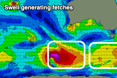 The first swell seen later yesterday and today was generated by the first of these fronts, with it being relatively weak and broad, but a reinforcing S/SW swell will arrive tomorrow morning as it eases generated by a good fetch of strong W'ly winds that moved through our swell window yesterday.
This should keep the Mornington Peninsula around 4ft for most of tomorrow morning with 2-3ft sets on the Surf Coast, dropping out temporarily into Sunday morning.
This will be ahead of our third and final pulse of stronger S/SW groundswell, generated by a strong low that developed south-west of Western Australia yesterday. While the fetch attached to this low looks aimed towards Antarctica, due to the curve of the Earth (sorry flat Earthers), we'll see the severe-gale NW winds generating a fun sized, punchy swell for us.
The size from these systems are tricky and one a few months ago over-performed, but I feel we'll see a strong kick in size Sunday afternoon when it arrives, building to 3ft+ on the Surf Coast swell magnets and 4-6ft on the Mornington Peninsula. The morning looks smaller and to 2ft and 3ft respectively.
The swell will likely peak overnight, then easing steadily Monday from 2-3ft and 4ft respectively on the Surf Coast and Mornington Peninsula.
Now, coming back to the local conditions and tomorrow morning will see improving, peaky waves with winds swinging moderate to fresh E/NE around dawn, possibly tending more NE at times while easing late morning, then giving into sea breezes mid-afternoon onwards.
Sunday looks good for most of the day with a fresh N/NE offshore, holding until mid-afternoon, then giving into late afternoon sea breezes. Monday, as the swell eases should see fresh N/NE winds, holding from the NE into the late afternoon and evening.
Tuesday morning should be clean again with a straighter N'ly offshore, but the swell will be all but gone, tiny on the Surf Coast and a leftover 2ft on the Mornington Peninsula.
Following this the outlook is average, with a small, late forming low south-west of us due to generate a weak SW swell for later Wednesday/Thursday but a trough associated with the low will bring onshore winds, persisting well into next weekend as a slow moving high pushes in behind it.
Therefore make the most of the coming days on the beaches. Have a great weekend!
Comments
"sorry flat Earthers". Gold!
Really fun looking few days ahead. Just need the Yorkes forey to sort itself out for next weekend and i'll be rating the post-lockdown period about a 9/10.
Foreys don't usually sort themselves out. Gotta get under there and give it a good scrub.
Haha.
The obvious reason we get NW swell is due to the reflection off the ice shelf ;-)
Ah, yes of course, damn it.
You mean the edge of the dome?
I remember that swell, it was really fun with quite a bit of kick. Still so weird to look at the fetch pointing down to Antarctica and imagining it refracting, rather than just bouncing off, pinball style.
Correct me if I'm wrong Craig but that GCP swell hasn't really showed up on the bouys or at the beach?? Any thoughts?
My bad, it ain't Sunday yet, lol.
Swells 1/2 the size of yesterday on the morn pen. Back to bed for me.
Edit: definitely not 2-3ft!
Kicked since? This AM was the low point but looks 3ft sets now..
CS looks promising
Yeh I think it did, came up with the tide
Buoy's suggests maybe but at the beach...Meh, hidden under summer SE windswell junk. We've had a great run, so definitely can't complain. Sure it'll be a long few months before it'll get going properly again but at least the beachie boys will now get their fill.
WAG, there was a window around lunch on the Bellarine stretch where there were some decent sets before the wind got into it. Decent fun.
Oh! Nice BR.... I was being forced (peer-group pressure) too jump off the BH pier at the time... my young children think it's great but I tell ya, it's scary at my age.....not that I'd tell them that though;)
It can still have a bit of a curve on it, but be a flat expanse. On a giant turtle.