Varied week, looking good into next

Victoria Forecast by Craig Brokensha (issued Monday 5th October)
Best Days: Wednesday keen surfers selected spots, Thursday, Saturday morning Surf Coast, next week
Recap
A better pulse of W/SW groundswell into Friday afternoon/evening held Saturday morning but with gusty offshore winds, favouring the beaches. The Surf Coast was to 3ft on the sets, with 4-5ft sets to the east.
Sunday morning saw a little less size with variable winds as a surface trough started to move in from the west. Conditions improved as the morning went on ahead of a strong S/SW change (in the wake of the trough) which has persisted into today, mixed in with a SW groundswell from yesterday afternoon.
This week and weekend (Oct 6 - 11)
A strong high is moving in behind the weekend's trough and this will leave fresh to strong S'ly winds blowing across the state tomorrow, tending S/SE into the afternoon.
 Our moderate sized mid-period S/SW swell is still on the cards, with a slight upgrade to the expected size. A strong polar front formed south-southwest of Western Australia on the weekend, generating a good fetch of strong to gale-force W/SW winds. This then broadened while projecting up towards us, through our south-western and then southern swell window, with it currently passing under Tassie in a weakened form.
The swell should build through tomorrow and peak into the afternoon with 4-5ft sets on the Surf Coast magnets, 6ft to possibly 8ft on the Mornington Peninsula. This will be with those poor onshore winds though.
The easing trend should be slow through Wednesday with the Surf Coast dropping from 4ft on the swell magnets, with 5-6ft sets to the east. Conditions should start to improve as well as the high moves east, swinging winds more easterly. The Surf Coast will be poor under fresh but easing E/SE winds, while protected spots to the east look best with dawn E/SE winds, easing and tending E-E/NE for a period during the morning before reverting back to the E/SE.
Thursday looks the pick though windy and tricky as a trough moves in from the west, swinging winds from a strong but easing NE'ly at dawn, around to a strong NW'ly through the morning, increasing further through the afternoon.
The S/SW swell will be on the ease with sets dropping from 2-3ft on the Surf Coast and 4ft or so to the east, with some peaky SE windswell also in the mix.
On Friday a weak W/SW windswell is expected to be in the mix, generated on the backside of the trough as it forms into a low and drops south-east across us. This will bring strong W/SW winds and a spike in windswell with local W/NW winds. The Surf Coast may see weak 2-3ft waves in the morning, though easing through the day.
From the weekend and into next week we've got some fun, inconsistent groundswell on the cards along with favourable winds as the storms stay at arms length from us, while a strong high sits to our north, squeezed by deepening inland troughs across South Australia.
This will direct winds out of the north-eastern quadrant into next week after westerly winds Saturday, south-east Sunday.
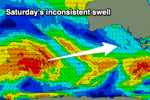 Looking at the swell and an initial inconsistent W/SW groundswell should build later Friday and peak Saturday, generated by a strong, slow moving Southern Ocean frontal progression that's currently around the Heard Island region. A broad fetch of W/SW gales will move slowly east while weakening today, with a secondary fetch of W/SW gales developing on its tail, closer to Western Australia.
It'll be inconsistent but the W/SW groundswell should offer infrequent 3ft sets on the Surf Coast magnets, 4-5ft to the east but with W/NW winds, shifting SW into the afternoon.
 The swell looks to ease a touch Sunday with S/SE winds, ahead of a better SW groundswell Monday. The source of this swell will be a stronger, closer frontal progression moving in from the Heard Island region but weakening south of a position under Western Australia.
A moderate to large sized SW groundswell is due, filling in Monday and providing inconsistent 4ft+ waves on the Surf Coast, 6ft to possibly 8ft to the east with N/NE winds. There's a secondary reinforcing swell on the cards for Tuesday with similar winds, but more on this Wednesday.