South by south-west

Victoria Forecast by Craig Brokensha (issued Friday 25th September)
Best Days: Keen surfers Monday, beaches Tuesday
Recap
Yesterday morning saw a mix of weak swells to 2ft to occasionally 3ft on the Surf Coast, 4ft to the east along with improving conditions in protected spots as winds shifted more offshore and increased.
This morning the swell has bottomed out and early winds out of the north have created clean conditions but a trough sitting just west of Cape Otway will move in late morning, bringing an onshore change.
This weekend and next week (Sep 26 – Oct 2)
Once winds swing onshore later morning, this will signal the change in wind for the coming weekend, with only a couple of possible surfing options (for the desperate) across the whole state, and more so into Sunday.
 A broad, cold low is moving slowly in from the west and this will bring strong SW winds behind it as it continues east tomorrow. With this a localised and weak increase in windswell is expected, coming in around 3ft+ on the Surf Coast and 4-5ft to the east.
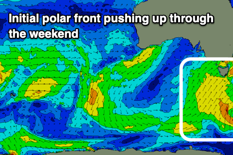
A better though still weak mid-period S/SW swell is due into Sunday and Monday, generated by a broad polar front being dragged up in the wake of the low. This should bring a building S/SW swell Sunday afternoon, kicking to 3ft+ on the Surf Coast and 4-5ft to the east. The morning is likely to be a bit smaller as we fall in between swells.
Winds will unfortunately remain onshore, moderate to fresh out of the S/SW and persisting most of the day.
Monday morning is looking better but a little dicey with winds easing further but lingering out of the S/SW. We may see patches of variable breezes but keep your expectations low and you should find a fun wave. The S/SW swell will be on the ease, dropping from 3ft across the Surf Coast and 4ft or so to the east.
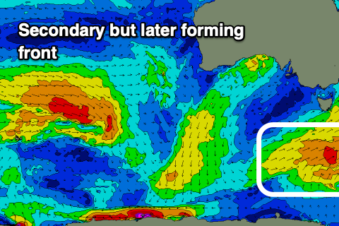 Tuesday is now looking a touch better, with a secondary polar front firing up just within our southern swell window on Sunday, producing a reinforcing pulse of S/SW swell.
It looks to be fairly south in direction which isn't great for the Mornington Peninsula but we should see the Surf Coast holding around 2ft+ most of the day with surf around 3ft+ to the east.
Winds will swing offshore out of the N/NE and hold all day, favouring the beaches.
Make the most of it as the swell will fade Wednesday and early N'ly winds are due to swing W/NW.
We then look to the mid-latitude frontal activity that's forecast to move in from the west through next week. Before this there's no swell due, with the first possible signs of energy popping up later Thursday but more so Friday.
Initial activity in our far swell window will be superseded by close-range activity in and under the country next Wednesday/Thursday onwards. A strengthening mid-latitude front should produce a moderate sized pulse of mid-period W/SW swell for Friday, with secondary storms generating reinforcing swells next weekend.
No major size is expected and winds will vary between fronts but there should be fun options across most spots from Friday through early the following week. More on this in Monday's update. Have a great weekend!
Comments
So far, so not so bad for armageddon day. Haven’t had any of the 100% 20 mm and it really ain’t that cold outdoors. I never get that rain prediction thing..
Oh it's coming, wait for the trough and cold air to move in proper. It's just hitting Lorne.
Ahhhh. So I’ve typed to soon so to speak ;)
Check the bom radar bone..
Snap!
Just hit Drugmana with avengeance.
Radar is your friend..
https://www.facebook.com/groups/117730445004997/permalink/3165287993582545/
Ohh yeah!
Epic!
Just tried to attach a photo of a waterfall off the 12 apostles today from the port Campbell community page one of the coolest photos I’ve seen from this coast for sure
Got it! Wow!
amazing!
Holy moly. That's insane....a sneaky little bank at Gibbo's maybe?
Can’t currently access it the lower part of the staircase was damaged so gates closed
C'mon girls! It's just a rain band.........with a bit of cold air behind it.
Already past Cape Otway and the wind's only blowing about 15knts there.
ring are you implying that girls don't like rain and cold air?
Thats not very woke of you
Ha, yeah, waterfalls and snow! ;p
Air temps at Aireys Inlet reached a max of 8.4 degrees at 10:30 degrees.
It's dropped to 4.9 degrees in the last hour.
Not sure about records, but I have a feeling today might end up being in the top 5% for lowest daily maxima.
OK, climate stats for Aireys Inlet in September:
Mean max: 16.2°C
Mean min: 8.2°C
Lowest Max temp: 7.9°C (05 Sep 1995)
Decile 1 Max temperature: 12.8°C
Aireys down to 3.4 and feels like -1.0 at 1pm. Sort of glad there aren't any waves.
Wow!
Still a balmy 9 on the pen but that cloud mass ain’t far away now!
Crept up to a max of 9.8 degrees at 4:30pm.
Currently 21 degrees on the Tweed. Kids got a little sunburnt yesty.
46 mm of rain in Warrnambool overnight and this morning
The Apostles waterfall photo is incredible
How ya looking now Bone? Good weather for hanging the washing out? Ha.
Unfortunately the rain has delayed the hanging of washing out, but in turn, has brought the drinking of beer forward. Can’t complain sir :)
Humbly concede that it’s chilly now. Under a roof watching the fire through the window.
Perfect!
That waterfall is absolutely amazing. So that's the way that the cliffs eventually erode at the top...
Balmy!
Not really surprising. Victorian weather forecast: cold, wet and windy.
Yep, nothing worthwhile down here benny, best too skip this part of the world, I've heard that the Goldcoast has some surfing spots.
Haha. One day i'll make it down there Walk around, one day :)
;)
sick photos lads,great day for no surf