Significant swell and weather event inbound

Victoria Forecast by Craig Brokensha (issued Wednesday 29th April)
Best Days: Surf Coast tomorrow, experienced surfers only protected spots Friday through Sunday, Tuesday
Recap
Monday's mix of swells remained a good and solid size into yesterday morning, easing from 4ft+ across the Surf Coast, 6ft+ to the east and with favourable winds all day as the swell became a little more manageable on the exposed beaches late in the day.
Today the swell has eased further with favourable winds for the beaches and good to great surf. A new W/SW groundswell should kick the Surf Coast magnets to 3ft to occasionally 4ft this afternoon and 5-6ft+ to the east but a W/SW-SW change will move through early afternoon, creating average conditions. Therefore make the most of this morning.
This week and weekend (Apr 30 – May 3)
This afternoon's W/SW groundswell will ease back into tomorrow with inconsistent and easing 3ft sets on the Surf Coast swell magnets, 4-5ft to the east and a deepening and stalling mid-latitude low south-west of us will bring strengthening NW winds. An embedded front moving around the low is likely to bring a W/SW change late afternoon, so surf before then. We're not likely to see any new swell from the low until Friday.
 Now, looking at this dynamic and tricky low, it looks to actually play nice through Friday in that we'll see large levels of building S/SW groundswell with favourable winds for protected spots.
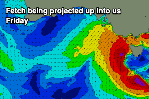
As it initially forms tomorrow, a fetch of strong to gale-force S'ly winds will be aimed towards South Australia, but be too west and out of our swell window.
As the day progresses though we'll see the low move slowly east, with a fetch of gale to severe-gale S/SW winds being projected up through our southern swell window tomorrow evening and through Friday. Storm-force winds are actually expected just out of our swell window Friday evening off the South Coast of Tassie. It'll be quite a significant storm due to its slow movement and sustained intensity.
This will generate a large and powerful increase in building S/SW groundswell through Friday and the stalling nature of the low will see strong and windy but workable W/NW winds through the morning, shifting W/SW mid-late afternoon.
It's tricky to nail down the exact sizes, but we're likely to see the Surf Coast building from 4-5ft in the morning, 6ft to possibly 8ft on the Mornington Peninsula, further to 8ft and 10ft+ respectively into the mid-late afternoon. It'll be one of the largest swell events for a while and I've split the middle between the intensity forecast by GFS and EC. If it goes GFS's way we'll see even larger surf.
There'll also be plenty of snow in the apline regions linked with a deep cold pool in the upper atmosphere and additional moisture sucked down from the north-west.
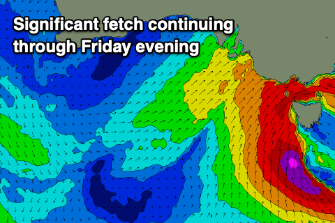 Saturday morning is likely to offer similar sized waves as the low removes slow moving into Friday evening with severe-gales continuing to be projected up and into us, easing slowly Saturday as the low moves gradually east.
Winds will only be favourable for protected spots though and only for the experienced with strong W/SW breezes, shifting SW through the day.
Sunday still looks large owing to S/SW gales continuing to be aimed through our swell window right up until Saturday afternoon. At this stage we're likely to still see 5-6ft sets on the Surf Coast, 6ft to occasionally 8ft to the east owing to the swell direction. Winds will remain poor and gusty from the W/SW though, possibly W'ly early for a period on the Surf Coast.
Into next week we'll see the swell take a more steady drop in size with lingering SW winds Monday, still great for the beaches Tuesday and out of the N'th as a high moves in from the west. Following this there's nothing significant until later in the week, but more on this Friday.
Comments
The south-east of the country is getting an absolute hosing right now..
What you can also see here is the cold air edging into Adelaide and the Great Dividing Range creating a rain shadow east of the divide.
That looks mint. Give me a front, make it a double!
Melbourne has also taken out last year's rainfall total, by 29 April:
https://www.theage.com.au/national/victoria/cold-front-batters-victoria-...
Hi Craig,
Where do you view those images?
Can I politely ask what the point of the long range forecast is considering it changes every day? For example, over the past three days the forecast for 11 May - chosen at random! - has gone from 3 to 2 to 6 ft with a similar variety in wind predictions.
I would’ve thought it nigh on impossible to predict so far out so why bother?
I don’t rely on it and remain a happy subscriber so genuinely asking out of interest.
This is only in certain circumstances though, and that being the coming dynamic low pressure system is hard to resolve by the leading global forecast models.
The models are now converging on its movements and strength, but until that's uncertain, anything beyond falls to the way side.
This is also the value of the Forecaster Notes.
Its pretty reasonable patty. You want fluctuations, check out the N NSW/SE QLD.
Thanks for those comments. Genuinely not criticising, just wondering. And at least I now know where Herd Island is!
Yeah, no worries at all.
For most coastlines around the world, and in particular east-facing coastlines, a 16 day forecast is a waste of time. However, for tropical coasts facing into vast ocean basins - think Indo and Hawaii - then they can serve a purpose.
For example, it's possible to recognise foundational characteristics of lows rounding the Cape of Good Hope, and what they might mean for East Nusa Tenggara in two weeks time. That's how long it takes for a a low to coalesce, create a wind field and a subsequent swell, and for that swell to diagonally traverse the Indian Ocean.
Similarly, lows that bomb near the Kamchatka Peninsula won't deliver swell till a fortnight after the first signs show on the Siberian Shield. It takes another 3-4 days for those swells to hit the lefts of northern Peru, so the interval between initial recognition and the swell making landfall can be even longer than 16 days.
Because of the way the site is standardised, we can't pick and choose the forecast interval for each region, hence they all get a 16 day forecast even if the coastline doesn't warrant it.
Looks like plenty of essential travel this weekend.
From the couch to the fridge
We have a great rapport with the local police and are working to keep our very small community safe. Those who have escaped a fine are removed and remembered. Stay home. You won’t enjoy yourself.
Petrol cheap as chips the moment. People dont give a fuck.
We care. And so do the local authorities.
please read that in context in that ill be doing my part but boy howdy is there a lot of other fuckers out there
#endthelockdowntoclearthelineup
Yes Nick crowds haven't exactly thinned that much and petrol under $1 a litre is really cheap and expected to get much cheaper. The Ruskies and Arabs are having a race to the bottom so there is an excess capacity and they are running out of places to store it!
portland? is the location portland?
No wonder we are a bloody angry bunch. Idiots ruin it all for the decent travelers. Hope you're proud. Don't come back.
Ah yes I remember something about that town......Aluminium smelter!
How much snow are you thinking out of this Craig?
I can't really see the resorts opening this year. But you never know.
Yeh will be interesting how they handle it. Presumably if unrestricted travel becomes allowable again they could run at reduced capacity, max 2 to a chairlift etc.
Ski resorts are planning on a season. Maybe with reduced capacity but maybe not, depending on travel restrictions. Yours truly was just offered an instructors' job up there. If there's no travel restrictions, resorts are going to be desperate for staff as international ski bums can't get here.
If resorts don't open and there's plenty of snow, we can expect a record number of back country deaths as inexperienced punters head out beyond their depth. It's been shambolic in the USA after the lifts were shut.
Will have a look later, it'll melt quickly though even if we get a huge dump with the ground surface still being quite warm.
Snow in may will not stay
And even June can be too soon
The long range forecast is important for providing hope in the dark times
True!
Anyone know if you can travel from vic to nsw in order to look for work? I cant find any accurate information on the travel restrictions.
I don't think you can travel to "look for work" but can travel if you have work. A mate had to cross the VIC/SA border for a switchboard install. He called our local cop shop and was given a green light. Just get the coppers name who said it is OK.
Friday looks interesting
The bukit peninsula is gonna light up i tell ya ;)
Portsea Outside Corner?
Land of the lefts
Sure does. I know of a secret little Vicco point that will be doing it's thing but can't justify travelling at this time. Local grovel in the Bay for me.
Good man style master 1970. I will do the same and refrain from heading to Frankston for a paddle.
Good on you Stylemaster, I'd actually like to see some Bay pics for the novelty value of it all. Used to dream the Swan river had waves when I was a teenager.
Little?
I meant Westernport Bay. And VL my secret little point is not on the West Coast. Us Hoax Coasters rarely head to the dark side!
All you Surf Coast fuckwits* better not travel up to Bryyyyyytin on Friday and ruin it for everyone!
*Which I believe is the preferred nomenclature on Swellnet forums. Apologies if I’m mistaken.
Fair point Patrick0710. Won't be travelling to surf. Might be too much west in the swell for Bryyyyytin. Looks like more of a Frankston swell.
Yep, good chart reading there VL. Just avoid making eye contact with the local crew.
And park next to the police station or under a CCTV camera.
Craig it seems there has been an abnormal amount of intense storm activity between the southwest pacific and southeast Australia,before,and since,that SSW event. What's happening there? Is it just a peak of a multi-year cycle&can we expect that zone to finally go quiet or is it the New Normal?
This is looking like the best mystical novelty spot swell in years. Can’t wait to see all 5000 of you at fisho’s, Lorne, Merricks, Shoreham! Covid swell 2020!!
infectious stoke
How amazing is the weather! Great frontal sequence. Thanks Craig. As surfers we are lucky to be active participants in Mother Nature's weather show. I am looking forward to see what unfolds over the next few days down here. Should be a few options for some interesting waves hopefully.
From a mate yesterday, some of the shots of the front moving through have been insane!

Not to labia the point, but this is very reminiscent of a lot of Gary's photography, Craig
Classic Gary G. You win the internet for April with that comment.
Ha.
VL, you care to put a size on surf coast tomorrow? Interested to hear your thoughts
Nope. This is a seriously hard swell to put a size on it.
Boohoo
I've seen storms set up in that predicted location a few times before. The fetch is really close and Tasmania could block a fair bit of the swell. Sometimes they produce seriously big waves and on other occasions we miss out completely.
I will give you a free tip: you don't want to be hiking the Overland Track or trying to summit Cradle Mountain over the next few days.
My not so favourite spot in Tassie...Cradle Mountain. Every time I have been there (motorcycle touring) the weather is rubbish and it is freezing - even in November. Should lock the place up and leave it to the local fauna.
Wasn't the first thing that came to my mind but great vision...
Tomorrow for locations in Bass Strait is still super tricky. It looks like Saturday will see the most size here now easily with.
Will post the charts and you'll see why when our 18z update comes through.
Here's how tricky tomorrow is. We can see the fetch is just within Bass Strait's swell window this afternoon through early tomorrow morning, but then squeezes off to the west at 10am tomorrow morning and then eases into the afternoon.
4pm this arvo


10pm this evening
4am tomorrow AM
10am tomorrow AM
4pm tomorrow arvo
Then we see that purple fetch of severe-gale S-S/SW winds project up and towards us from 4pm tomorrow afternoon through Saturday. This for me will bring the really large stuff.
10pm tomorrow evening


4am Sat morning
10am Sat morning.. weakening and going east.
With this I'd expect tomorrow to pulse in size large through the late morning but then steady, with the much more significant size Saturday from the sling shot up and into us.
Yeh, it does look like a seriously active and close 'captured fetch system' for Saturday Craig but I don't think you're taking into account, the pesky K.I swell shadow affect.
From my previous observations, a lot of similar, relativily shorter period storm swells from this approach, just don't seam to produce the full/massive swell impact locally but other places still do ok..... any thoughts?
I find KI doesn't have any huge effect in the eventual swell on the coast, it'd be more so the fetch alignment not being ideal to get through Bass Strait. Too south right off the Tassie West Coast etc.
Any fetch with S/SW winds or more SW aligned developing west of a line drawn south from Mawson Bay is fine.
The constantly changing energy is fascinating.
With the shitty wind on Saturday. Bummer.
Good breakdown though Craig, thanks for that
Nothing shitty about wind go sailing my friend:)
Shippies?
Those charts are like Huey is bowling a big inswinger into Vic. SE Tassie is at the non-striker's end, in nice calm winds - they will still see the swell this thing generates, right?
And the size on west coast of Tas - I'll be looking at Sorrell every few hours!
Yeah SE Tas is tricky, the bottom infeed will likely bring a S'ly swell but the strongest winds now look to west of the South Arm swell window, not ideal.
Puking snow at the moment!
Will be interesting to watch the swell roll in tomorrow
Looked fairly consistent and nice and clean on the Torquay came just on dark. Still no sign of it on the CS buoy yet.
Fetch is located too west for this swell to show on CS for now, and give an early indication. Check those charts above and you can see why. Love these lows, super tricky to forecast!
Thanks. Just looking at the Torquay cam and could see a lot of lines coming through. Looked Arctic. No one out.
Wooly old morning. Winter has arrived
A cold, inconsistent 2ft in WPB. No signs of any new swell yet
Be interesting to watch the run-in later in the arvo
Fark!! Hotham.
Jeepers! Must be 30-40cm!!
Latest update: https://www.swellnet.com/reports/forecaster-notes/victoria/2020/05/01/cold-large-and-windy-weekend