Lots of quality surf days this week

Victoria Forecast by Craig Brokensha (issued Monday 24th February)
Best Days: Tomorrow morning, keen surfers Surf Coast Wednesday morning, Thursday protected spots, Friday morning protected spots, early Saturday protected spots
Recap
Poor conditions across the Surf Coast all weekend but workable waves to the east both Saturday and Sunday, cleanest on the later.
Today our good mix of long-period SW groundswell and mid-period energy has filled in with 3-4ft waves on the Surf Coast, 6ft+ to the east and with light and workable winds.
The swell should hold all afternoon with moderate S/SE winds into the afternoon.
This week and weekend (Feb 25 – Mar 1)
We've got a much more active week of surf ahead, especially for the Surf Coast, but firstly tomorrow morning should be great on the Mornington Peninsula and other exposed beaches.
Today's mix of SW groundswell and mid-period swell are expected to ease off slowly tomorrow, likely from 3ft+ on the Surf Coast and the 5ft range on the Mornington Peninsula with a moderate morning N/NE offshore, giving into a SW change late morning/midday. Therefore don't dawdle and get in through the morning.
A temporary low point in swell is still expected Wednesday morning back to 2ft or so on the Surf Coast and 3-4ft+ to the east along with a W/NW breeze, favouring spots to the west of Melbourne.
We then look at the polar frontal progression linked to the run of swell from Wednesday afternoon through the end of the week and weekend.
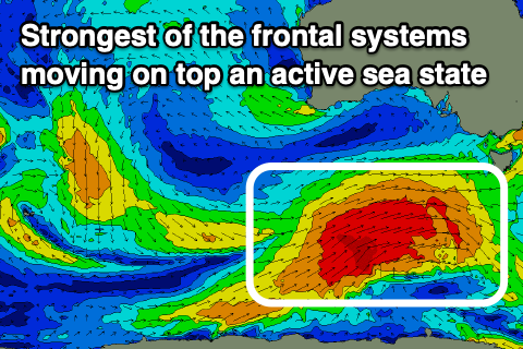
A strengthening node of the Long Wave Trough is moving in from the west, bringing with it an increase in frontal activity through the Southern Ocean.
The first of these systems has formed south-west of WA with a burst of pre-frontal strong to gale-force W/NW winds being followed by a broader and better pre-frontal W/NW fetch, and then post-frontal, slightly weaker W/SW fetch that will break down on approached towards us.
 We'll see an initial small increase in W/SW groundswell building Wednesday afternoon from the initial burst of W/NW winds, with an additional and lower quality increase in SW windswell. Wednesday afternoon's increase in size will be spoilt by strong SW winds, with sets due to reach 4ft on the Surf Coast and 6ft+ on the Mornington Peninsula, dropping a touch into Thursday morning with a secondary pulse of SW groundswell coming in at 3-4ft and 6ft respectively. Winds will revert back to the W/NW Thursday and hold most of the day as the strongest of the polar fronts starts edging towards us.
This frontal system should generate a building mid-period SW swell into the late afternoon ahead of a larger SW groundswell Friday.
The storm will develop on the polar shelf tomorrow, with a tight fetch of severe-gale W/NW winds due to track east-northeast ideally through our south-western swell window while broadening but slightly weakening. This frontal progression will move on top of the active sea state created before it, boosting the swell potential, with a large SW groundswell now on track for Friday.
The swell is due to build through the day and peak into the afternoon to 6ft on the Surf Coast and 8ft+ to the east. Looking at the local winds and a morning W/NW offshore is due swinging around to the W/SW-SW later morning/midday and S/SW into the afternoon when the swell peaks.
Moving into the weekend we'll see a slow drop in size as a weaker follow up front moving in behind the strongest system later week buffers the easing trend.
Winds look SW to S/SE on Saturday, possibly W/NW early on the Surf Coast and less favourable from the S/SE-SE on Sunday, but we'll have a closer look at this and any changes to the expected size late week on Wednesday.
Comments
Music to my ears
Boom!
Yeah craigos!
This is looking interesting for the Sandgropers with the remnants of TC Esther making her presence felt and then another strong storm coming in from Indo on the back of that.
https://www.tropicaltidbits.com/analysis/models/?model=gfs®ion=aus&pk...
About bloody time that you justified your existence Craig!
Always wondered Craig, how come the East Coast gets storms (e.g. TC Uesi) right off the coast and there are still light variable winds at the beaches, and yet the vicco storms off our SW coast create strong WSW winds everywhere!? Don’t understand
Mate, maybe conduct some further reading and/or research bud, you'll actually enjoy your new found analytical insight to our weather and inturn, this will add extra value to your new found understanding of the how and why.
I've been training all week so I can out-paddle, out-froth and out-snake all you locals. Urbansurf is booked out so I'm gunna burn the lot of you Sydney style!
Go out to Steps. The locals are super friendly out there.
I might take up supping for the week.
the wave's are pretty fat around here aye mate. bird rock is about the only good spot on the surf coast, nice barrels out there that are not to heavy, perfect for the groms!!
I'm curious Billie, can you outline your out-froth training schedule? Paddle I know the routine, snake training umm yeah I'll be right, but I'd like to know the froth training.
I’ve been hanging out with some Brazzos for my froth training
Scored some fun waves over the last few days.. water warm, not many crew around either. Really noticed the unsuitability of my (East Coast-centric) equipment too.. fine for the smaller peakier stuff but it lacked the necessary drive to get around those steep walls.
If your around later in the week you might need to find something more suited! Some fun ones today.
It's been nice to be out there and have the big long lines coming through again. Flatter rockers, length of rail and as much drive as your fins can pack. When I go up your way Ben I enjoy the peakiness of the beachies as it means a high wave count, often bowly or barrelly too. While down here, perhaps go the highline on current equipment, you might make up for the drive?