Increased activity from the weekend

Victoria Forecast by Craig Brokensha (issued Wednesday 25th September)
Best Days: Exposed beaches tomorrow, Surf Coast Saturday morning and Sunday morning, keen surfers Monday, Tuesday
Recap
A background W/SW groundswell provided a little more size than expected yesterday, with 2-3ft sets on the Surf Coast, 4ft to the east with generally clean and fun waves all day west of Melbourne.
The swell has eased into this morning, clean again across the Surf Coast, bumpy to the east.
This week and weekend (Sep 26 – 29)
We'll see the exposed beaches clean up through tomorrow as a dawn N/NW breeze shifts N/NE later morning and E/NE into the afternoon. Size wise though, there'll not much on offer, with our current swell easing, replaced with a small mid-period S/SW swell from a polar front south-west of Tassie yesterday.
Only small inconsistent 2ft sets are due on the Surf Coast, 2ft to maybe 3ft on the Mornington Peninsula, easing into Friday morning.
Winds on Friday morning will be favourable again and N/NW, giving into a fresh afternoon W/SW change.
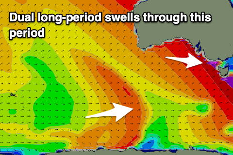
Moving into the weekend and our inconsistent long-range SW groundswell is still on track, with the intense and slow moving polar low linked to it now weakening south-west of WA.
A fetch of severe-gale to storm-force W/SW winds were aimed through our swell window, with the swell expected to arrive later Friday and peak through Saturday (possibly under sized early) to an inconsistent 3-4ft on the Surf Coast swell magnets and 6ft on the sets to the east. There may be the odd sneaky bigger cleanup set at the peak of the swell, but these will be rare.
 Winds on Saturday will be lingering from the W/SW-SW in the wake of Friday's change, though likely W/NW early around Torquay. The afternoon will see more sea breezey S/SE winds.
Sunday looks cleaner with a W/NW offshore expected until later morning along with 3ft+ waves on the Surf Coast and 4-6ft sets to the east.
Our secondary pulse of slightly bigger and more consistent SW groundswell for Monday is still on track, with a secondary slightly weaker polar low now forming east of Heard Island.
A fetch of severe-gale W'ly winds will be generated, weakening but remaining gale-force while moving under the country over the coming days. The low will continue onwards and under Tassie on the weekend.
The swell is due Monday with good 3-5ft waves on the Surf Coast and 6ft+ to the east, but winds will be onshore out of the S/SW tending S/SE as a high moves in after Sunday's change. Winds won't be too fresh so there should be OK options for the keen.
Tuesday looks much better as winds swing back to the N/NE, cleaning up the beaches as the swell eases from 3ft to possibly 4ft on the Surf Coast and 4-6ft to the east. Following this there's nothing major on the cards for the rest of the week besides an inconsistent, long-range mid-period W/SW swell, but more on this Friday.
Comments
Glimpse through the bushes.


Gary G would be hiding in there somewhere.
Haha.
Not sure about those 13th Beach bushes. I reckon Gary G is more of a West Point Impossible or an East Point Addis type of bloke.
He probably has drones by now